![](/images/other/stat-length.png)
![Randonnée Marche Pontchâteau - Circuit des Hérons - Photo](https://media.geolcdn.com/t/1900/400/ext.pjpeg?maxdim=2&url=https%3A%2F%2Fstatic1.geolcdn.com%2Fsiteimages%2Fupload%2Ffiles%2F1553511878bg_sport_marche.png)
Circuit des Hérons
neoroll44
Utilisateur
![Longueur](/images/other/stat-length.png)
![Altitude max](https://static1.geolcdn.com/siteimages/upload/files/1508320355ic_sort_altitude_max_24dp.png)
![Dénivelé positif](https://static1.geolcdn.com/siteimages/upload/files/1508320355ic_sort_den_pos_24dp.png)
![Km-Effort](/images/other/stat-length.png)
![Altitude min](https://static1.geolcdn.com/siteimages/upload/files/1508320355ic_sort_altitude_min_24dp.png)
![Dénivelé négatif](https://static1.geolcdn.com/siteimages/upload/files/1508320355ic_sort_den_neg_24dp.png)
![Boucle](https://static1.geolcdn.com/siteimages/upload/files/16400158638029165_repeat_loop_refresh_sync_direction_icon.png)
![Marche](https://static1.geolcdn.com/sitytour/trail-icons/101.png)
1h41
Difficulté : Facile
![Scannez ce code QR pour ouvrir la randonnée dans l'application SityTrail](https://capi.geolives.com/qq0zvz2zws4bq2lad0pu/sitytour/trails/640943/qr.png?size=200)
Application GPS de randonnée GRATUITE
À propos
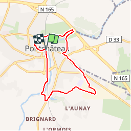
Randonnée Marche de 6,6 km à découvrir à Pays de la Loire, Loire-Atlantique, Pontchâteau. Cette randonnée est proposée par neoroll44.
Description
Quittez le parking des Lavoirs et longez la voie ferrée de façon à l’avoir sur votre droite. Prenez le chemin des centrais et continuez tout droit où vous passerez sous le viaduc.
1) Passez sous la voie ferrée et dirigez-vous vers le pont qui enjambe le Brivet. Au bout du pont, tournez à gauche et contournez la station d’épuration jusqu’à la départementale. Tournez à gauche, longez la D773 jusqu’au passage piéton. Traversez et prenez le petit chemin. Longez le terrain de football.
2) Au rond-point prenez le chemin en face puis tournez tout de suite à gauche. Continuez sur ce chemin et poursuivez en bifurquant à droite. Allez tout droit jusqu’à la rue Gutenberg où vous tournerez à gauche puis de nouveau à gauche rue Lavoisier. Au bout empruntez un chemin sur votre gauche.
3) Tournez à gauche et longez prudemment la rue du vélodrome jusqu’au rond-point où vous prendrez la sortie d’en face. Tournez à droite rue du commandant puis empruntez le chemin à gauche. Descendez jusqu’au Brivet où vous emprunterez le platelage avant de tourner à gauche pour prendre le petit pont qui enjambe le Brivet. Au bout, tournez à gauche et longez le Brivet.
4) Tournez à gauche, empruntez le pont, puis au bout tournez à droite. Empruntez le platelage le long de la rivière. Suivez le jusqu’au parking des Lavoirs.
Localisation
Commentaires
Randonnées à proximité
![Randonnée Marche Drefféac - Circuit des Pirogues - Photo](https://media.geolcdn.com/t/375/260/ext.jpg?maxdim=2&url=https%3A%2F%2Fstatic1.geolcdn.com%2Fsiteimages%2Fupload%2Ffiles%2F1553511878bg_sport_marche.png)
![Marche Marche](https://static1.geolcdn.com/sitytour/trail-icons/101.png)
Marche
![](/images/other/stat-length.png)
![](https://static1.geolcdn.com/siteimages/upload/files/16400158638029165_repeat_loop_refresh_sync_direction_icon.png)
![Randonnée Vélo Crossac - Crossac Ste Anne - Photo](https://media.geolcdn.com/t/375/260/ext.jpg?maxdim=2&url=https%3A%2F%2Fstatic1.geolcdn.com%2Fsiteimages%2Fupload%2Ffiles%2F1524743154velo.jpg)
![Vélo Vélo](https://static1.geolcdn.com/sitytour/trail-icons/200.png)
Vélo
![](/images/other/stat-length.png)
![](https://static1.geolcdn.com/siteimages/upload/files/16400158638029165_repeat_loop_refresh_sync_direction_icon.png)
![Randonnée Marche Pontchâteau - pontChateau - Photo](https://media.geolcdn.com/t/375/260/ext.jpg?maxdim=2&url=https%3A%2F%2Fstatic1.geolcdn.com%2Fsiteimages%2Fupload%2Ffiles%2F1553511878bg_sport_marche.png)
![Marche Marche](https://static1.geolcdn.com/sitytour/trail-icons/101.png)
Marche
![](/images/other/stat-length.png)
![](https://static1.geolcdn.com/siteimages/upload/files/16400158638029165_repeat_loop_refresh_sync_direction_icon.png)
![Randonnée Marche Pontchâteau - rando sur Ponchateau entre Brivet et cygognes - Photo](https://media.geolcdn.com/t/375/260/ext.jpg?maxdim=2&url=https%3A%2F%2Fstatic1.geolcdn.com%2Fsiteimages%2Fupload%2Ffiles%2F1553511878bg_sport_marche.png)
![Marche Marche](https://static1.geolcdn.com/sitytour/trail-icons/101.png)
Marche
![](/images/other/stat-length.png)
![](https://static1.geolcdn.com/siteimages/upload/files/16400158638029165_repeat_loop_refresh_sync_direction_icon.png)
![Randonnée Marche Sainte-Anne-sur-Brivet - St Anne sur brivet - De St Omer au canal - Photo](https://media.geolcdn.com/t/375/260/ext.jpg?maxdim=2&url=https%3A%2F%2Fstatic1.geolcdn.com%2Fsiteimages%2Fupload%2Ffiles%2F1553511878bg_sport_marche.png)
![Marche Marche](https://static1.geolcdn.com/sitytour/trail-icons/101.png)
Marche
![](/images/other/stat-length.png)
![](https://static1.geolcdn.com/siteimages/upload/files/16400158638029165_repeat_loop_refresh_sync_direction_icon.png)