![](/images/other/stat-length.png)
![Randonnée Vélo Pont-Sainte-Maxence - au5v 2oct 2016 - Photo](https://media.geolcdn.com/t/1900/400/ext.pjpeg?maxdim=2&url=https%3A%2F%2Fstatic1.geolcdn.com%2Fsiteimages%2Fupload%2Ffiles%2F1524743154velo.jpg)
au5v 2oct 2016
gilbertdu60
Utilisateur
![Longueur](/images/other/stat-length.png)
Longueur
18,9 km
![Altitude max](https://static1.geolcdn.com/siteimages/upload/files/1508320355ic_sort_altitude_max_24dp.png)
Altitude max
150 m
![Dénivelé positif](https://static1.geolcdn.com/siteimages/upload/files/1508320355ic_sort_den_pos_24dp.png)
Dénivelé positif
240 m
![Km-Effort](/images/other/stat-length.png)
Km-Effort
22 km
![Altitude min](https://static1.geolcdn.com/siteimages/upload/files/1508320355ic_sort_altitude_min_24dp.png)
Altitude min
87 m
![Dénivelé négatif](https://static1.geolcdn.com/siteimages/upload/files/1508320355ic_sort_den_neg_24dp.png)
Dénivelé négatif
239 m
![Boucle](https://static1.geolcdn.com/siteimages/upload/files/16400158638029165_repeat_loop_refresh_sync_direction_icon.png)
Boucle
Oui
Date de création :
2016-10-03 00:00:00.0
Dernière modification :
2016-10-03 00:00:00.0
![Vélo](https://static1.geolcdn.com/sitytour/trail-icons/200.png)
3h24
Difficulté : Moyen
![Scannez ce code QR pour ouvrir la randonnée dans l'application SityTrail](https://capi.geolives.com/qq0zvz2zws4bq2lad0pu/sitytour/trails/640211/qr.png?size=200)
Application GPS de randonnée GRATUITE
À propos
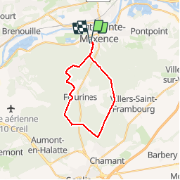
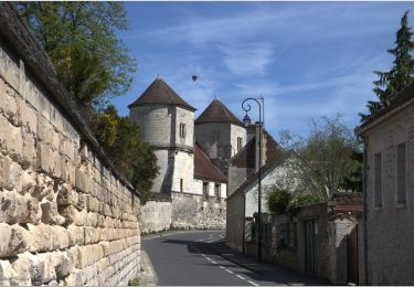
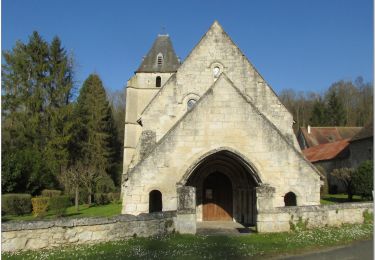
Randonnée Vélo de 18,9 km à découvrir à Hauts-de-France, Oise, Pont-Sainte-Maxence. Cette randonnée est proposée par gilbertdu60.
Description
Sortie vélo antenne AU5V Pont ste maxence, parcours PNR forêt d' halatte modifié au départ de Pont
Localisation
Pays :
France
Région :
Hauts-de-France
Département/Province :
Oise
Commune :
Pont-Sainte-Maxence
Localité :
Unknown
Départ:(Dec)
Départ:(UTM)
470667 ; 5460276 (31U) N.
Commentaires
Randonnées à proximité
![Randonnée Marche Beaurepaire - La mare aux oiseaux - Beaurepaire - Photo](https://media.geolcdn.com/t/375/260/ext.jpg?maxdim=2&url=https%3A%2F%2Fservices.sitytrail.com%2FGeolivesWS%2FDownloadMedia.ashx%3FTrailID%3D172831%26Media%3D14265_3.jpg)
![Marche Marche](https://static1.geolcdn.com/sitytour/trail-icons/101.png)
La mare aux oiseaux - Beaurepaire
Marche
Moyen
(1)
Beaurepaire,
Hauts-de-France,
Oise,
France
![](/images/other/stat-length.png)
8,4 km | 10,2 km-effort
2h 10min
![](https://static1.geolcdn.com/siteimages/upload/files/16400158638029165_repeat_loop_refresh_sync_direction_icon.png)
Oui
![Randonnée Marche Fleurines - Fleurines Grand parcours - Photo](https://media.geolcdn.com/t/375/260/ext.jpg?maxdim=2&url=https%3A%2F%2Fstatic1.geolcdn.com%2Fsiteimages%2Fupload%2Ffiles%2F1553511878bg_sport_marche.png)
![Marche Marche](https://static1.geolcdn.com/sitytour/trail-icons/101.png)
Fleurines Grand parcours
Marche
Facile
(1)
Fleurines,
Hauts-de-France,
Oise,
France
![](/images/other/stat-length.png)
20 km | 24 km-effort
5h 8min
![](https://static1.geolcdn.com/siteimages/upload/files/16400158638029165_repeat_loop_refresh_sync_direction_icon.png)
Oui
![Randonnée Marche Pontpoint - Mont Pagnotte Grand parcours - Photo](https://media.geolcdn.com/t/375/260/ext.jpg?maxdim=2&url=https%3A%2F%2Fstatic1.geolcdn.com%2Fsiteimages%2Fupload%2Ffiles%2F1553511878bg_sport_marche.png)
![Marche Marche](https://static1.geolcdn.com/sitytour/trail-icons/101.png)
Mont Pagnotte Grand parcours
Marche
Moyen
(2)
Pontpoint,
Hauts-de-France,
Oise,
France
![](/images/other/stat-length.png)
16,6 km | 22 km-effort
4h 36min
![](https://static1.geolcdn.com/siteimages/upload/files/16400158638029165_repeat_loop_refresh_sync_direction_icon.png)
Oui
![Randonnée V.T.T. Pont-Sainte-Maxence - ot 6 octobre 24 - Photo](https://media.geolcdn.com/t/375/260/4ba8675b-f1b4-4711-8652-1227646fd10f.jpg&format=jpg&maxdim=2)
![V.T.T. V.T.T.](https://static1.geolcdn.com/sitytour/trail-icons/202.png)
ot 6 octobre 24
V.T.T.
Moyen
Pont-Sainte-Maxence,
Hauts-de-France,
Oise,
France
![](/images/other/stat-length.png)
23 km | 27 km-effort
1h 54min
![](https://static1.geolcdn.com/siteimages/upload/files/16400158638029165_repeat_loop_refresh_sync_direction_icon.png)
Oui
![Randonnée V.T.C. Fleurines - randonnée Au5v OT Ccpoh halatte - Photo](https://media.geolcdn.com/t/375/260/e4619b64-6ffd-453c-8063-35f7d7e4513e.jpg&format=jpg&maxdim=2)
![V.T.C. V.T.C.](https://static1.geolcdn.com/sitytour/trail-icons/203.png)
randonnée Au5v OT Ccpoh halatte
V.T.C.
Facile
Fleurines,
Hauts-de-France,
Oise,
France
![](/images/other/stat-length.png)
30 km | 35 km-effort
Inconnu
![](https://static1.geolcdn.com/siteimages/upload/files/16400158638029165_repeat_loop_refresh_sync_direction_icon.png)
Oui
![Randonnée Cyclotourisme Pont-Sainte-Maxence - sortie AU5v Pentecôte 2022 - Photo](https://media.geolcdn.com/t/375/260/72742583-c7e6-4761-a433-7f77fdf4fdf5.jpg&format=jpg&maxdim=2)
![Cyclotourisme Cyclotourisme](https://static1.geolcdn.com/sitytour/trail-icons/204.png)
sortie AU5v Pentecôte 2022
Cyclotourisme
Facile
Pont-Sainte-Maxence,
Hauts-de-France,
Oise,
France
![](/images/other/stat-length.png)
26 km | 29 km-effort
Inconnu
![](https://static1.geolcdn.com/siteimages/upload/files/16400158638029165_repeat_loop_refresh_sync_direction_icon.png)
Oui
![Randonnée A pied Pont-Sainte-Maxence - balade pedestre 11 avril 2022 - Photo](https://media.geolcdn.com/t/375/260/80b47c68-2cf3-4ca1-99f4-54eb29551880.jpg&format=jpg&maxdim=2)
![A pied A pied](https://static1.geolcdn.com/sitytour/trail-icons/100.png)
balade pedestre 11 avril 2022
A pied
Facile
Pont-Sainte-Maxence,
Hauts-de-France,
Oise,
France
![](/images/other/stat-length.png)
7,2 km | 9,1 km-effort
2h 4min
![](https://static1.geolcdn.com/siteimages/upload/files/16400158638029165_repeat_loop_refresh_sync_direction_icon.png)
Oui
![Randonnée Vélo électrique Pont-Sainte-Maxence - balade printanière du 23 mars - Photo](https://media.geolcdn.com/t/375/260/91c5558e-d792-4457-81d8-689705073d14.jpg&format=jpg&maxdim=2)
![Vélo électrique Vélo électrique](https://static1.geolcdn.com/sitytour/trail-icons/205.png)
balade printanière du 23 mars
Vélo électrique
Facile
Pont-Sainte-Maxence,
Hauts-de-France,
Oise,
France
![](/images/other/stat-length.png)
22 km | 26 km-effort
2h 14min
![](https://static1.geolcdn.com/siteimages/upload/files/16400158638029165_repeat_loop_refresh_sync_direction_icon.png)
Oui
![Randonnée Vélo électrique Pont-Sainte-Maxence - sortie 18 janvier 22 - Photo](https://media.geolcdn.com/t/375/260/a2770608-26de-4cec-b3ee-2ce8fe1ad8d3.jpg&format=jpg&maxdim=2)
![Vélo électrique Vélo électrique](https://static1.geolcdn.com/sitytour/trail-icons/205.png)
sortie 18 janvier 22
Vélo électrique
Facile
Pont-Sainte-Maxence,
Hauts-de-France,
Oise,
France
![](/images/other/stat-length.png)
23 km | 27 km-effort
2h 4min
![](https://static1.geolcdn.com/siteimages/upload/files/16400158638029165_repeat_loop_refresh_sync_direction_icon.png)
Oui