Randonnée Marche Saint-Joseph - Piton de l'entonnoir - Photo
 Fdum
Fdum

Utilisateur

© OpenStreetMap contributors
Longueur
Longueur
1,3 km
Altitude max
Altitude max
446 m
Dénivelé positif
Dénivelé positif
71 m
Km-Effort
Km-Effort  
2,3 km
Altitude min
Altitude min
369 m
Dénivelé négatif
Dénivelé négatif
74 m
Boucle
Boucle
Oui
Date de création :
2016-09-28 00:00:00.0
Dernière modification :
2016-09-28 00:00:00.0

(0 Avis)

Marche
Marche
36m
Difficulté : Facile

Scannez ce code QR pour ouvrir la randonnée dans l'application SityTrail

Application GPS de randonnée GRATUITE

Logo SityTrail SityTrail

IGN / Instituts géographiques

Télécharger SityTrail sur l'App Store Télécharger SityTrail sur Google Play

Logo SityTrail SityTrail World

Le monde est à vous

Télécharger SityTrail sur l'App Store Télécharger SityTrail sur Google Play Télécharger SityTrail sur Huawei AppGallery

À propos

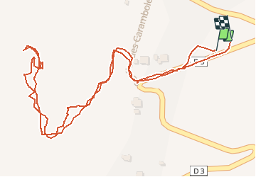
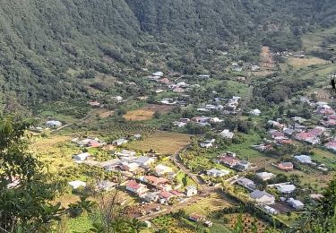
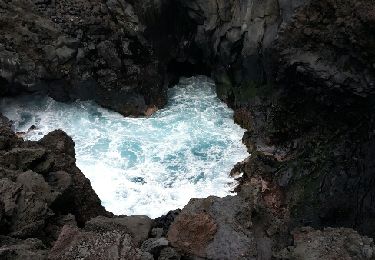
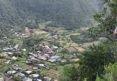
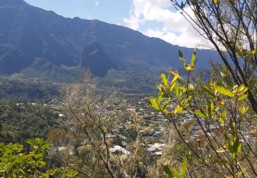
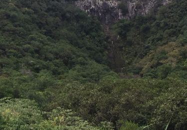
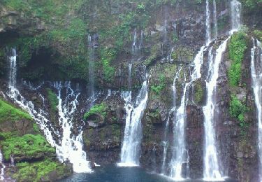
Randonnée Marche de 1,3 km à découvrir à La Réunion, Inconnu, Saint-Joseph. Cette randonnée est proposée par Fdum.

Description

Point de vue au dessus de ST JOSEPH. Boucle possible.

Profil altimétrique

Localisation

Pays :
France
Région :
La Réunion
Département/Province :
Inconnu
Commune :
Saint-Joseph
Localité :
Unknown
Départ:(UTM)
356629 ; 7637746 (40K) S.

Randonnées à proximité

Randonnée Marche Saint-Joseph - Boucle des Margosiers - Photo
Marche
GilbertLP

Marche

Très difficile
Saint-Joseph, La Réunion, Inconnu, France
14 km | 25 km-effort
5h 7min
Oui
Randonnée Marche Saint-Joseph - Sentier littoral de Langevin - Photo
Marche
Guy Léandre Jista

Marche

Facile
Saint-Joseph, La Réunion, Inconnu, France
3,4 km | 3,8 km-effort
1h 5min
Oui
Randonnée Marche Saint-Joseph - La Réunion - Boucle du Piton Babet à Saint-Joseph - Photo
Marche
olive2b

Marche

Très facile
(1)
Saint-Joseph, La Réunion, Inconnu, France
3,2 km | 4,7 km-effort
1h 1min
Oui
Randonnée Marche Saint-Joseph - Langevin 18 03 2015 - Photo
Marche
chouchou-slc

Marche

Facile
Saint-Joseph, La Réunion, Inconnu, France
4,8 km | 5,5 km-effort
3h 2min
Non
Randonnée Marche Saint-Joseph - L'aire du Rond à la Plaine des Grègues et le sentier de Curcuma - Photo
Marche
GilbertLP

Marche

Moyen
Saint-Joseph, La Réunion, Inconnu, France
5,2 km | 9,2 km-effort
1h 52min
Oui
Randonnée Marche Saint-Joseph - boucle cascade bras rouge - Photo
Marche
GilbertLP

Marche

Difficile
Saint-Joseph, La Réunion, Inconnu, France
61 km | 121 km-effort
10h 8min
Non
Randonnée Marche Saint-Joseph - piton du rond  - Photo
Marche
olivier5960

Marche

Difficile
Saint-Joseph, La Réunion, Inconnu, France
10,7 km | 22 km-effort
5h 18min
Non
Randonnée Marche Saint-Joseph - La Réunion - Cascade du Grand Galet  - Photo
Marche
olive2b

Marche

Très facile
Saint-Joseph, La Réunion, Inconnu, France
559 m | 829 m-effort
11min
Non
Randonnée V.T.T. Saint-Joseph - st joseph - st Philippe par la route forestière  - Photo
V.T.T.
XavierFaidix

V.T.T.

Moyen
Saint-Joseph, La Réunion, Inconnu, France
42 km | 57 km-effort
4h 30min
Non


Fermer
Mes abonnements