![](/images/other/stat-length.png)
![Randonnée Marche Pellafol - Canyon de l'Infernet - Photo](https://media.geolcdn.com/t/1900/400/ext.pjpeg?maxdim=2&url=https%3A%2F%2Fstatic1.geolcdn.com%2Fsiteimages%2Fupload%2Ffiles%2F1553511878bg_sport_marche.png)
Canyon de l'Infernet
rigol05
Utilisateur
![Longueur](/images/other/stat-length.png)
Longueur
13,6 km
![Altitude max](https://static1.geolcdn.com/siteimages/upload/files/1508320355ic_sort_altitude_max_24dp.png)
Altitude max
1105 m
![Dénivelé positif](https://static1.geolcdn.com/siteimages/upload/files/1508320355ic_sort_den_pos_24dp.png)
Dénivelé positif
488 m
![Km-Effort](/images/other/stat-length.png)
Km-Effort
20 km
![Altitude min](https://static1.geolcdn.com/siteimages/upload/files/1508320355ic_sort_altitude_min_24dp.png)
Altitude min
798 m
![Dénivelé négatif](https://static1.geolcdn.com/siteimages/upload/files/1508320355ic_sort_den_neg_24dp.png)
Dénivelé négatif
483 m
![Boucle](https://static1.geolcdn.com/siteimages/upload/files/16400158638029165_repeat_loop_refresh_sync_direction_icon.png)
Boucle
Oui
Date de création :
2016-09-20 00:00:00.0
Dernière modification :
2016-09-20 00:00:00.0
![Marche](https://static1.geolcdn.com/sitytour/trail-icons/101.png)
4h25
Difficulté : Moyen
![Scannez ce code QR pour ouvrir la randonnée dans l'application SityTrail](https://capi.geolives.com/qq0zvz2zws4bq2lad0pu/sitytour/trails/633470/qr.png?size=200)
Application GPS de randonnée GRATUITE
À propos
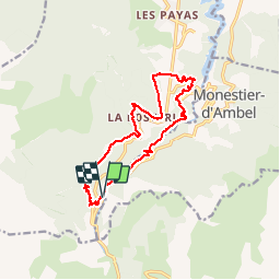
Randonnée Marche de 13,6 km à découvrir à Auvergne-Rhône-Alpes, Isère, Pellafol. Cette randonnée est proposée par rigol05.
Description
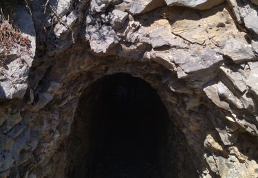
Au départ du parking des Gillardes, circuit longeant la Souloise en passant par le canyon de l'Infernet. Retour par l'ancien canal de Pellafol.
Localisation
Pays :
France
Région :
Auvergne-Rhône-Alpes
Département/Province :
Isère
Commune :
Pellafol
Localité :
Unknown
Départ:(Dec)
Départ:(UTM)
728527 ; 4960041 (31T) N.
Commentaires
Randonnées à proximité
![Randonnée Marche Le Dévoluy - Pierre Baudinard - Photo](https://media.geolcdn.com/t/375/260/dea0799c-94e0-4315-9166-bde984af0e12.jpg&format=jpg&maxdim=2)
![Marche Marche](https://static1.geolcdn.com/sitytour/trail-icons/101.png)
Pierre Baudinard
Marche
Difficile
Le Dévoluy,
Provence-Alpes-Côte d'Azur,
Hautes-Alpes,
France
![](/images/other/stat-length.png)
11 km | 19,6 km-effort
4h 27min
![](https://static1.geolcdn.com/siteimages/upload/files/16400158638029165_repeat_loop_refresh_sync_direction_icon.png)
Oui
![Randonnée Marche Pellafol - 38 source gaillarde internet ch fée - Photo](https://media.geolcdn.com/t/375/260/34314d4b-0476-4e34-bbdb-55d6e7cd37b0.jpg&format=jpg&maxdim=2)
![Marche Marche](https://static1.geolcdn.com/sitytour/trail-icons/101.png)
38 source gaillarde internet ch fée
Marche
Moyen
Pellafol,
Auvergne-Rhône-Alpes,
Isère,
France
![](/images/other/stat-length.png)
13,3 km | 19,9 km-effort
6h 32min
![](https://static1.geolcdn.com/siteimages/upload/files/16400158638029165_repeat_loop_refresh_sync_direction_icon.png)
Non
![Randonnée Ski de randonnée Le Dévoluy - col sou la tête d'oriol et crête de la clape - Photo](https://media.geolcdn.com/t/375/260/9ecbcea7-5655-4fbe-b488-b03ce3d93479.jpg&format=jpg&maxdim=2)
![Ski de randonnée Ski de randonnée](https://static1.geolcdn.com/sitytour/trail-icons/503.png)
col sou la tête d'oriol et crête de la clape
Ski de randonnée
Moyen
Le Dévoluy,
Provence-Alpes-Côte d'Azur,
Hautes-Alpes,
France
![](/images/other/stat-length.png)
14,6 km | 31 km-effort
6h 9min
![](https://static1.geolcdn.com/siteimages/upload/files/16400158638029165_repeat_loop_refresh_sync_direction_icon.png)
Oui
![Randonnée Ski de randonnée Le Dévoluy - Le Nid - Photo](https://media.geolcdn.com/t/375/260/5bab7be5-98e2-4d6d-b137-94826649cb1f.jpg&format=jpg&maxdim=2)
![Ski de randonnée Ski de randonnée](https://static1.geolcdn.com/sitytour/trail-icons/503.png)
Le Nid
Ski de randonnée
Difficile
Le Dévoluy,
Provence-Alpes-Côte d'Azur,
Hautes-Alpes,
France
![](/images/other/stat-length.png)
15,8 km | 34 km-effort
8h 0min
![](https://static1.geolcdn.com/siteimages/upload/files/16400158638029165_repeat_loop_refresh_sync_direction_icon.png)
Oui
![Randonnée Ski de randonnée Le Dévoluy - le pas de la cloche. - Photo](https://media.geolcdn.com/t/375/260/6f4d97b3-6792-482f-be87-1058e226e432.jpg&format=jpg&maxdim=2)
![Ski de randonnée Ski de randonnée](https://static1.geolcdn.com/sitytour/trail-icons/503.png)
le pas de la cloche.
Ski de randonnée
Difficile
Le Dévoluy,
Provence-Alpes-Côte d'Azur,
Hautes-Alpes,
France
![](/images/other/stat-length.png)
7,1 km | 19,2 km-effort
6h 15min
![](https://static1.geolcdn.com/siteimages/upload/files/16400158638029165_repeat_loop_refresh_sync_direction_icon.png)
Non
![Randonnée Marche Le Dévoluy - Le Faraut. Pic pierroux - Photo](https://media.geolcdn.com/t/375/260/f70077a3-127b-4a4c-a1bb-36cf90d608f0.jpg&format=jpg&maxdim=2)
![Marche Marche](https://static1.geolcdn.com/sitytour/trail-icons/101.png)
Le Faraut. Pic pierroux
Marche
Moyen
Le Dévoluy,
Provence-Alpes-Côte d'Azur,
Hautes-Alpes,
France
![](/images/other/stat-length.png)
10,3 km | 25 km-effort
7h 10min
![](https://static1.geolcdn.com/siteimages/upload/files/16400158638029165_repeat_loop_refresh_sync_direction_icon.png)
Oui
![Randonnée Marche Pellafol - R44 Le Bénitier - Photo](https://media.geolcdn.com/t/375/260/c09c5294-f23e-4ece-8780-88830b0ef2c5.jpg&format=jpg&maxdim=2)
![Marche Marche](https://static1.geolcdn.com/sitytour/trail-icons/101.png)
R44 Le Bénitier
Marche
Moyen
(1)
Pellafol,
Auvergne-Rhône-Alpes,
Isère,
France
![](/images/other/stat-length.png)
14 km | 25 km-effort
3h 0min
![](https://static1.geolcdn.com/siteimages/upload/files/16400158638029165_repeat_loop_refresh_sync_direction_icon.png)
Oui
![Randonnée Marche Pellafol - R43 Les Gillardes et Le Canyon de l'Infernet de Pellafol - Photo](https://media.geolcdn.com/t/375/260/ext.jpg?maxdim=2&url=https%3A%2F%2Fservices.sitytrail.com%2FGeolivesWS%2FDownloadMedia.ashx%3FTrailID%3D890901%26Media%3D34932a86-a06f-4702-8669-5c5d0130cca7.jpg)
![Marche Marche](https://static1.geolcdn.com/sitytour/trail-icons/101.png)
R43 Les Gillardes et Le Canyon de l'Infernet de Pellafol
Marche
Très facile
(2)
Pellafol,
Auvergne-Rhône-Alpes,
Isère,
France
![](/images/other/stat-length.png)
6,1 km | 8,5 km-effort
1h 48min
![](https://static1.geolcdn.com/siteimages/upload/files/16400158638029165_repeat_loop_refresh_sync_direction_icon.png)
Oui
![Randonnée Marche Le Dévoluy - R30 Le Puits des Bans - Photo](https://media.geolcdn.com/t/375/260/ext.jpg?maxdim=2&url=https%3A%2F%2Fservices.sitytrail.com%2FGeolivesWS%2FDownloadMedia.ashx%3FTrailID%3D890889%26Media%3Df7b1d6b4-ea22-4c01-9d63-d59f6ee8ceaf.jpg)
![Marche Marche](https://static1.geolcdn.com/sitytour/trail-icons/101.png)
R30 Le Puits des Bans
Marche
Facile
(2)
Le Dévoluy,
Provence-Alpes-Côte d'Azur,
Hautes-Alpes,
France
![](/images/other/stat-length.png)
5,2 km | 6,4 km-effort
3h 8min
![](https://static1.geolcdn.com/siteimages/upload/files/16400158638029165_repeat_loop_refresh_sync_direction_icon.png)
Oui
Très jolie randonnée majoritairement sous bois avec de jolis points de vue.