![](/images/other/stat-length.png)
![Randonnée Marche Névache - Tour du Grand Seru - Photo](https://media.geolcdn.com/t/1900/400/ext.pjpeg?maxdim=2&url=https%3A%2F%2Fstatic1.geolcdn.com%2Fsiteimages%2Fupload%2Ffiles%2F1553511878bg_sport_marche.png)
Tour du Grand Seru
oliseb
Utilisateur
![Longueur](/images/other/stat-length.png)
![Altitude max](https://static1.geolcdn.com/siteimages/upload/files/1508320355ic_sort_altitude_max_24dp.png)
![Dénivelé positif](https://static1.geolcdn.com/siteimages/upload/files/1508320355ic_sort_den_pos_24dp.png)
![Km-Effort](/images/other/stat-length.png)
![Altitude min](https://static1.geolcdn.com/siteimages/upload/files/1508320355ic_sort_altitude_min_24dp.png)
![Dénivelé négatif](https://static1.geolcdn.com/siteimages/upload/files/1508320355ic_sort_den_neg_24dp.png)
![Boucle](https://static1.geolcdn.com/siteimages/upload/files/16400158638029165_repeat_loop_refresh_sync_direction_icon.png)
![Marche](https://static1.geolcdn.com/sitytour/trail-icons/101.png)
6h25
Difficulté : Difficile
![Scannez ce code QR pour ouvrir la randonnée dans l'application SityTrail](https://capi.geolives.com/qq0zvz2zws4bq2lad0pu/sitytour/trails/633381/qr.png?size=200)
Application GPS de randonnée GRATUITE
À propos
Randonnée Marche de 18,1 km à découvrir à Provence-Alpes-Côte d'Azur, Hautes-Alpes, Névache. Cette randonnée est proposée par oliseb.
Description
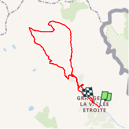
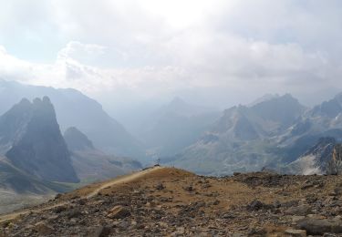
Cette balade propose une variante du tour du Grand Seru, sans passer par le col de la Vallée Étroite. Au départ, on passera voir le lac Vert, le détour est très court et vaut le détour. Un sentier moins fréquenté y monte. De retour sur le GR 5 on bifurque a gauche un peu avant le pont de la Fonderie pour grimper au Prat du Plan, puis on rejoint le col des Méandes à 2727 m, point culminant de la journée. On bascule ensuite en direction du col de la vallée étroite, sans y passer. Cela permet de raccourcir le parcours de 2 km.Pour cela, au lac du Peyron, prendre a droite en quitant le GR 57. Le sentier traverse d'abord le pierrier. Le sentier n'est pas très visible sur 100 mètres,il est ensuite bien marqué lorsqu'il longe le ruisseau sur la rive droite. On rejoint le GR 5 dans la plaine de Tavernette. De là, on rejoint le point de départ par le GR 5.
Localisation
Commentaires
Randonnées à proximité
![Randonnée Marche Névache - Lac Vert.Vallée Etroite.(27-09-17) - Photo](https://media.geolcdn.com/t/375/260/ext.jpg?maxdim=2&url=https%3A%2F%2Fservices.sitytrail.com%2FGeolivesWS%2FDownloadMedia.ashx%3FTrailID%3D836355%26Media%3Dfix__20170927160031.jpg)
![Marche Marche](https://static1.geolcdn.com/sitytour/trail-icons/101.png)
Marche
![](/images/other/stat-length.png)
![](https://static1.geolcdn.com/siteimages/upload/files/16400158638029165_repeat_loop_refresh_sync_direction_icon.png)
![Randonnée Marche Névache - les granges de la vallée étroite au refuge du Mont Thabor - Photo](https://media.geolcdn.com/t/375/260/ext.jpg?maxdim=2&url=https%3A%2F%2Fservices.sitytrail.com%2FGeolivesWS%2FDownloadMedia.ashx%3FTrailID%3D654587%26Media%3Dfix__20161029145821.jpg)
![Marche Marche](https://static1.geolcdn.com/sitytour/trail-icons/101.png)
Marche
![](/images/other/stat-length.png)
![](https://static1.geolcdn.com/siteimages/upload/files/16400158638029165_repeat_loop_refresh_sync_direction_icon.png)
![Randonnée V.T.T. Névache - Tour des Rois Mages en VTT - Névache - Photo](https://media.geolcdn.com/t/375/260/ext.jpg?maxdim=2&url=https%3A%2F%2Fservices.sitytrail.com%2FGeolivesWS%2FDownloadMedia.ashx%3FTrailID%3D105140%26Media%3D8755_6.jpg)
![V.T.T. V.T.T.](https://static1.geolcdn.com/sitytour/trail-icons/202.png)
V.T.T.
![](/images/other/stat-length.png)
![](https://static1.geolcdn.com/siteimages/upload/files/16400158638029165_repeat_loop_refresh_sync_direction_icon.png)
![Randonnée Marche Névache - Col roche noire - Photo](https://media.geolcdn.com/t/375/260/677a67a8-134f-4e40-9c36-524ac13be98e.jpg&format=jpg&maxdim=2)
![Marche Marche](https://static1.geolcdn.com/sitytour/trail-icons/101.png)
Marche
![](/images/other/stat-length.png)
![](https://static1.geolcdn.com/siteimages/upload/files/16400158638029165_repeat_loop_refresh_sync_direction_icon.png)
![Randonnée Marche Névache - le Mont Thabor - Photo](https://media.geolcdn.com/t/375/260/ext.jpg?maxdim=2&url=https%3A%2F%2Fservices.sitytrail.com%2FGeolivesWS%2FDownloadMedia.ashx%3FTrailID%3D1010217%26Media%3Dfix__20180724163126.jpg)
![Marche Marche](https://static1.geolcdn.com/sitytour/trail-icons/101.png)
Marche
![](/images/other/stat-length.png)
![](https://static1.geolcdn.com/siteimages/upload/files/16400158638029165_repeat_loop_refresh_sync_direction_icon.png)
![Randonnée Marche Névache - Vallée étroite refuge du Thabor - Photo](https://media.geolcdn.com/t/375/260/caa80d0d-fb96-4075-98b9-465015f706c8.jpg&format=jpg&maxdim=2)
![Marche Marche](https://static1.geolcdn.com/sitytour/trail-icons/101.png)
Marche
![](/images/other/stat-length.png)
![](https://static1.geolcdn.com/siteimages/upload/files/16400158638029165_repeat_loop_refresh_sync_direction_icon.png)
![Randonnée sport Névache - Vallée étroite thabor - Photo](https://media.geolcdn.com/t/375/260/97f1c275-6e3e-47a5-b5da-c9a6fca0b09d.jpg&format=jpg&maxdim=2)
sport
![](/images/other/stat-length.png)
![](https://static1.geolcdn.com/siteimages/upload/files/16400158638029165_repeat_loop_refresh_sync_direction_icon.png)
![Randonnée Marche Névache - J4 2023 - Le Thabor épisode 2 - Photo](https://media.geolcdn.com/t/375/260/6eb284de-df6c-41f9-bcd4-8d0010541a10.jpg&format=jpg&maxdim=2)
![Marche Marche](https://static1.geolcdn.com/sitytour/trail-icons/101.png)
Marche
![](/images/other/stat-length.png)
![](https://static1.geolcdn.com/siteimages/upload/files/16400158638029165_repeat_loop_refresh_sync_direction_icon.png)
![Randonnée Marche Névache - Mont Thabor à partir des Granges - Photo](https://media.geolcdn.com/t/375/260/b11e8d82-1743-4a03-9b5b-b7f5a70282e9.jpg&format=jpg&maxdim=2)
![Marche Marche](https://static1.geolcdn.com/sitytour/trail-icons/101.png)
Marche
![](/images/other/stat-length.png)
![](https://static1.geolcdn.com/siteimages/upload/files/16400158638029165_repeat_loop_refresh_sync_direction_icon.png)