![](/images/other/stat-length.png)
![Randonnée Marche Voujeaucourt - Soup'Rando 2016 7,6 Km - Photo](https://media.geolcdn.com/t/1900/400/ext.pjpeg?maxdim=2&url=https%3A%2F%2Fstatic1.geolcdn.com%2Fsiteimages%2Fupload%2Ffiles%2F1553511878bg_sport_marche.png)
Soup'Rando 2016 7,6 Km
Guytoumo
Utilisateur
![Longueur](/images/other/stat-length.png)
![Altitude max](https://static1.geolcdn.com/siteimages/upload/files/1508320355ic_sort_altitude_max_24dp.png)
![Dénivelé positif](https://static1.geolcdn.com/siteimages/upload/files/1508320355ic_sort_den_pos_24dp.png)
![Km-Effort](/images/other/stat-length.png)
![Altitude min](https://static1.geolcdn.com/siteimages/upload/files/1508320355ic_sort_altitude_min_24dp.png)
![Dénivelé négatif](https://static1.geolcdn.com/siteimages/upload/files/1508320355ic_sort_den_neg_24dp.png)
![Boucle](https://static1.geolcdn.com/siteimages/upload/files/16400158638029165_repeat_loop_refresh_sync_direction_icon.png)
![Marche](https://static1.geolcdn.com/sitytour/trail-icons/101.png)
2h00
Difficulté : Facile
![Scannez ce code QR pour ouvrir la randonnée dans l'application SityTrail](https://capi.geolives.com/qq0zvz2zws4bq2lad0pu/sitytour/trails/631328/qr.png?size=200)
Application GPS de randonnée GRATUITE
À propos
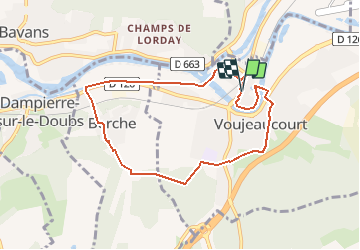
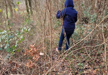
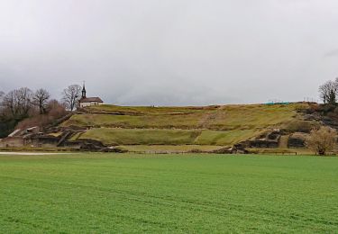
Randonnée Marche de 7,6 km à découvrir à Bourgogne-Franche-Comté, Doubs, Voujeaucourt. Cette randonnée est proposée par Guytoumo.
Description
En sortant de la salle des fêtes, traverser la rue et tourner à droite. Après le passage à niveau, descendre l’escalier sur la gauche, traverser le quartier du Maroc et suivre le canal vers la gauche. Après la pause de Berche, tourner à gauche au bout du chemin qui passe derrière les maisons. Retour par le bois des Chevalières, la rue de la Coudraie pour un apéritif puis la salle des fêtes pour le repas.
Localisation
Commentaires
Randonnées à proximité
![Randonnée Marche Dung - dung - Photo](https://media.geolcdn.com/t/375/260/a8063218-9e26-446b-a7f7-120eee643097.jpg&format=jpg&maxdim=2)
![Marche Marche](https://static1.geolcdn.com/sitytour/trail-icons/101.png)
Marche
![](/images/other/stat-length.png)
![](https://static1.geolcdn.com/siteimages/upload/files/16400158638029165_repeat_loop_refresh_sync_direction_icon.png)
![Randonnée Autre activité Voujeaucourt - de voujeaucourt à Dambelin, puis pont de roide - Photo](https://media.geolcdn.com/t/375/260/ext.jpg?maxdim=2&url=https%3A%2F%2Fservices.sitytrail.com%2FGeolivesWS%2FDownloadMedia.ashx%3FTrailID%3D737146%26Media%3Dfix__20170421173351.jpg)
![Autre activité Autre activité](https://static1.geolcdn.com/sitytour/trail-icons/900.png)
Autre activité
![](/images/other/stat-length.png)
![](https://static1.geolcdn.com/siteimages/upload/files/16400158638029165_repeat_loop_refresh_sync_direction_icon.png)
![Randonnée Marche nordique Courcelles-lès-Montbéliard - randonnée du lion 2024 - Photo](https://media.geolcdn.com/t/375/260/3f9f281c-6be4-4486-9d0b-09b5ebf8048a.jpg&format=jpg&maxdim=2)
![Marche nordique Marche nordique](https://static1.geolcdn.com/sitytour/trail-icons/102.png)
Marche nordique
![](/images/other/stat-length.png)
![](https://static1.geolcdn.com/siteimages/upload/files/16400158638029165_repeat_loop_refresh_sync_direction_icon.png)
![Randonnée sport Montbéliard - Marche de Noël - Photo](https://media.geolcdn.com/t/375/260/7aaf9d1e-59c1-4398-92df-e6e19d5ef6bb.jpg&format=jpg&maxdim=2)
sport
![](/images/other/stat-length.png)
![](https://static1.geolcdn.com/siteimages/upload/files/16400158638029165_repeat_loop_refresh_sync_direction_icon.png)
![Randonnée V.T.T. Montbéliard - rando VTT club de montbeliard - Photo](https://media.geolcdn.com/t/375/260/dc7d4ac0-476c-43ee-8bbf-18ea53e044c3.jpg&format=jpg&maxdim=2)
![V.T.T. V.T.T.](https://static1.geolcdn.com/sitytour/trail-icons/202.png)
V.T.T.
![](/images/other/stat-length.png)
![](https://static1.geolcdn.com/siteimages/upload/files/16400158638029165_repeat_loop_refresh_sync_direction_icon.png)
![Randonnée Marche Montbéliard - zz - Photo](https://media.geolcdn.com/t/375/260/2d06c4ab-787f-49e0-aee3-05473fb86371.jpg&format=jpg&maxdim=2)
![Marche Marche](https://static1.geolcdn.com/sitytour/trail-icons/101.png)
Marche
![](/images/other/stat-length.png)
![](https://static1.geolcdn.com/siteimages/upload/files/16400158638029165_repeat_loop_refresh_sync_direction_icon.png)
![Randonnée Cyclotourisme Arbouans - GTJ #1 - Photo](https://media.geolcdn.com/t/375/260/bc869aa9-9c52-4e94-806e-b0926b148033.jpg&format=jpg&maxdim=2)
![Cyclotourisme Cyclotourisme](https://static1.geolcdn.com/sitytour/trail-icons/204.png)
Cyclotourisme
![](/images/other/stat-length.png)
![](https://static1.geolcdn.com/siteimages/upload/files/16400158638029165_repeat_loop_refresh_sync_direction_icon.png)
![Randonnée Marche Mandeure - Théâtre Gallo-Romain de Mandeure 9 Km - Photo](https://media.geolcdn.com/t/375/260/074bd74f-4d1e-4ebb-b363-d85a06bb441a.jpg&format=jpg&maxdim=2)
![Marche Marche](https://static1.geolcdn.com/sitytour/trail-icons/101.png)
Marche
![](/images/other/stat-length.png)
![](https://static1.geolcdn.com/siteimages/upload/files/16400158638029165_repeat_loop_refresh_sync_direction_icon.png)
![Randonnée Marche Mandeure - Etape 1 GTJ : Mandeure à Pont de Roide - Photo](https://media.geolcdn.com/t/375/260/b9c884aa-6364-4edd-9de9-19d71f8c4dd8.jpg&format=jpg&maxdim=2)
![Marche Marche](https://static1.geolcdn.com/sitytour/trail-icons/101.png)
Marche
![](/images/other/stat-length.png)
![](https://static1.geolcdn.com/siteimages/upload/files/16400158638029165_repeat_loop_refresh_sync_direction_icon.png)