![](/images/other/stat-length.png)
![Randonnée Marche Villard-de-Lans - Chateau Julien - Photo](https://media.geolcdn.com/t/1900/400/ext.pjpeg?maxdim=2&url=https%3A%2F%2Fstatic1.geolcdn.com%2Fsiteimages%2Fupload%2Ffiles%2F1553511878bg_sport_marche.png)
Chateau Julien
pourrier
Utilisateur
![Longueur](/images/other/stat-length.png)
Longueur
12 km
![Altitude max](https://static1.geolcdn.com/siteimages/upload/files/1508320355ic_sort_altitude_max_24dp.png)
Altitude max
1554 m
![Dénivelé positif](https://static1.geolcdn.com/siteimages/upload/files/1508320355ic_sort_den_pos_24dp.png)
Dénivelé positif
469 m
![Km-Effort](/images/other/stat-length.png)
Km-Effort
18,3 km
![Altitude min](https://static1.geolcdn.com/siteimages/upload/files/1508320355ic_sort_altitude_min_24dp.png)
Altitude min
1284 m
![Dénivelé négatif](https://static1.geolcdn.com/siteimages/upload/files/1508320355ic_sort_den_neg_24dp.png)
Dénivelé négatif
472 m
![Boucle](https://static1.geolcdn.com/siteimages/upload/files/16400158638029165_repeat_loop_refresh_sync_direction_icon.png)
Boucle
Oui
Date de création :
2018-10-09 15:42:30.536
Dernière modification :
2018-10-09 15:42:33.735
![Marche](https://static1.geolcdn.com/sitytour/trail-icons/101.png)
3h58
Difficulté : Moyen
![Scannez ce code QR pour ouvrir la randonnée dans l'application SityTrail](https://capi.geolives.com/qq0zvz2zws4bq2lad0pu/sitytour/trails/628592/qr.png?size=200)
Application GPS de randonnée GRATUITE
À propos
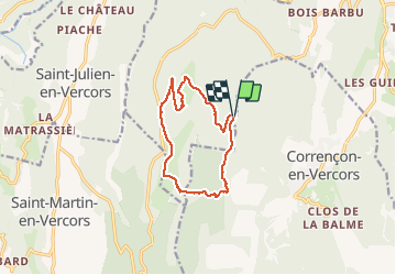
Randonnée Marche de 12 km à découvrir à Auvergne-Rhône-Alpes, Isère, Villard-de-Lans. Cette randonnée est proposée par pourrier.
Description
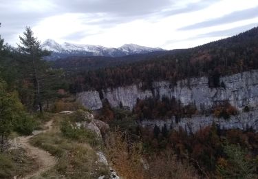
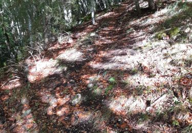
Belle ballade dans le vercors.
Baraque de Malaterre - Chateau Julien - Col d'Herbouilly - Pas de la Sambue - Baraque de Malaterre.
Localisation
Pays :
France
Région :
Auvergne-Rhône-Alpes
Département/Province :
Isère
Commune :
Villard-de-Lans
Localité :
Unknown
Départ:(Dec)
Départ:(UTM)
696833 ; 4990726 (31T) N.
Commentaires
Randonnées à proximité
![Randonnée Marche Villard-de-Lans - cabane de robon - Photo](https://media.geolcdn.com/t/375/260/f81b29b4-5a6d-4db9-85aa-f42275b30a70.jpg&format=jpg&maxdim=2)
![Marche Marche](https://static1.geolcdn.com/sitytour/trail-icons/101.png)
cabane de robon
Marche
Très facile
(1)
Villard-de-Lans,
Auvergne-Rhône-Alpes,
Isère,
France
![](/images/other/stat-length.png)
10,2 km | 15,8 km-effort
5h 25min
![](https://static1.geolcdn.com/siteimages/upload/files/16400158638029165_repeat_loop_refresh_sync_direction_icon.png)
Oui
![Randonnée V.T.T. Corrençon-en-Vercors - Grande Traversée des PréAlpes à VTT : Corrençon en Vercors - La Chapelle en Vercors - Photo](https://media.geolcdn.com/t/375/260/ext.jpg?maxdim=2&url=https%3A%2F%2Fservices.sitytrail.com%2FGeolivesWS%2FDownloadMedia.ashx%3FTrailID%3D102135%26Media%3D2525_2.jpg)
![V.T.T. V.T.T.](https://static1.geolcdn.com/sitytour/trail-icons/202.png)
Grande Traversée des PréAlpes à VTT : Corrençon en Vercors - La Chapelle en V...
V.T.T.
Difficile
(1)
Corrençon-en-Vercors,
Auvergne-Rhône-Alpes,
Isère,
France
![](/images/other/stat-length.png)
25 km | 36 km-effort
3h 30min
![](https://static1.geolcdn.com/siteimages/upload/files/16400158638029165_repeat_loop_refresh_sync_direction_icon.png)
Non
![Randonnée Marche Corrençon-en-Vercors - 38 tête chaudière - Photo](https://media.geolcdn.com/t/375/260/a1c58068-7436-4f98-99c2-e37838ff7810.jpg&format=jpg&maxdim=2)
![Marche Marche](https://static1.geolcdn.com/sitytour/trail-icons/101.png)
38 tête chaudière
Marche
Moyen
Corrençon-en-Vercors,
Auvergne-Rhône-Alpes,
Isère,
France
![](/images/other/stat-length.png)
10,8 km | 22 km-effort
7h 3min
![](https://static1.geolcdn.com/siteimages/upload/files/16400158638029165_repeat_loop_refresh_sync_direction_icon.png)
Oui
![Randonnée Marche Rencurel - 38 vire bourne goule noire - Photo](https://media.geolcdn.com/t/375/260/62b6a30b-af4a-4e09-9d99-ed85f47fb4ae.jpg&format=jpg&maxdim=2)
![Marche Marche](https://static1.geolcdn.com/sitytour/trail-icons/101.png)
38 vire bourne goule noire
Marche
Moyen
Rencurel,
Auvergne-Rhône-Alpes,
Isère,
France
![](/images/other/stat-length.png)
11,9 km | 24 km-effort
6h 44min
![](https://static1.geolcdn.com/siteimages/upload/files/16400158638029165_repeat_loop_refresh_sync_direction_icon.png)
Oui
![Randonnée Ski de randonnée Corrençon-en-Vercors - tête chaudière et petite moucherolle - Photo](https://media.geolcdn.com/t/375/260/c83b36a9-7a90-4b30-b04d-b8b7003402ab.jpg&format=jpg&maxdim=2)
![Ski de randonnée Ski de randonnée](https://static1.geolcdn.com/sitytour/trail-icons/503.png)
tête chaudière et petite moucherolle
Ski de randonnée
Facile
Corrençon-en-Vercors,
Auvergne-Rhône-Alpes,
Isère,
France
![](/images/other/stat-length.png)
11,9 km | 27 km-effort
5h 1min
![](https://static1.geolcdn.com/siteimages/upload/files/16400158638029165_repeat_loop_refresh_sync_direction_icon.png)
Oui
![Randonnée Marche Villard-de-Lans - 38 malaterre côté 2000 - Photo](https://media.geolcdn.com/t/375/260/f42b23e8-7328-4a7c-a1fa-911aa126df56.jpg&format=jpg&maxdim=2)
![Marche Marche](https://static1.geolcdn.com/sitytour/trail-icons/101.png)
38 malaterre côté 2000
Marche
Moyen
Villard-de-Lans,
Auvergne-Rhône-Alpes,
Isère,
France
![](/images/other/stat-length.png)
17,1 km | 25 km-effort
4h 23min
![](https://static1.geolcdn.com/siteimages/upload/files/16400158638029165_repeat_loop_refresh_sync_direction_icon.png)
Oui
![Randonnée Marche Villard-de-Lans - crête de Ferrière et pas de Rages - Photo](https://media.geolcdn.com/t/375/260/366bd126-b053-4e11-9a71-f5b68c70d969.jpg&format=jpg&maxdim=2)
![Marche Marche](https://static1.geolcdn.com/sitytour/trail-icons/101.png)
crête de Ferrière et pas de Rages
Marche
Moyen
Villard-de-Lans,
Auvergne-Rhône-Alpes,
Isère,
France
![](/images/other/stat-length.png)
13,5 km | 23 km-effort
6h 0min
![](https://static1.geolcdn.com/siteimages/upload/files/16400158638029165_repeat_loop_refresh_sync_direction_icon.png)
Oui
![Randonnée A pied Rencurel - La Balme Noire par la vire de Haute Valette - Photo](https://media.geolcdn.com/t/375/260/ext.jpg?maxdim=2&url=https%3A%2F%2Fstatic1.geolcdn.com%2Fsiteimages%2Fupload%2Ffiles%2F1545311037marcheuse_200dpi.jpg)
![A pied A pied](https://static1.geolcdn.com/sitytour/trail-icons/100.png)
La Balme Noire par la vire de Haute Valette
A pied
Difficile
(1)
Rencurel,
Auvergne-Rhône-Alpes,
Isère,
France
![](/images/other/stat-length.png)
10,5 km | 21 km-effort
Inconnu
![](https://static1.geolcdn.com/siteimages/upload/files/16400158638029165_repeat_loop_refresh_sync_direction_icon.png)
Oui
![Randonnée Marche Rencurel - 26 pas ferrière valchevriere - Photo](https://media.geolcdn.com/t/375/260/9dd39c24-ec71-4826-ac00-83cd7af45ed7.jpg&format=jpg&maxdim=2)
![Marche Marche](https://static1.geolcdn.com/sitytour/trail-icons/101.png)
26 pas ferrière valchevriere
Marche
Moyen
Rencurel,
Auvergne-Rhône-Alpes,
Isère,
France
![](/images/other/stat-length.png)
14,6 km | 24 km-effort
6h 1min
![](https://static1.geolcdn.com/siteimages/upload/files/16400158638029165_repeat_loop_refresh_sync_direction_icon.png)
Oui