![](/images/other/stat-length.png)
![Randonnée Marche Blancafort - BMF-160903.2 - Aubigny-Blancafort - Photo](https://media.geolcdn.com/t/1900/400/ext.pjpeg?maxdim=2&url=https%3A%2F%2Fservices.sitytrail.com%2FGeolivesWS%2FDownloadMedia.ashx%3FTrailID%3D627865%26Media%3Dfix__20160903162736.jpg)
BMF-160903.2 - Aubigny-Blancafort
randodan
Utilisateur
![Longueur](/images/other/stat-length.png)
Longueur
2,6 km
![Altitude max](https://static1.geolcdn.com/siteimages/upload/files/1508320355ic_sort_altitude_max_24dp.png)
Altitude max
183 m
![Dénivelé positif](https://static1.geolcdn.com/siteimages/upload/files/1508320355ic_sort_den_pos_24dp.png)
Dénivelé positif
23 m
![Km-Effort](/images/other/stat-length.png)
Km-Effort
2,9 km
![Altitude min](https://static1.geolcdn.com/siteimages/upload/files/1508320355ic_sort_altitude_min_24dp.png)
Altitude min
170 m
![Dénivelé négatif](https://static1.geolcdn.com/siteimages/upload/files/1508320355ic_sort_den_neg_24dp.png)
Dénivelé négatif
23 m
![Boucle](https://static1.geolcdn.com/siteimages/upload/files/16400158638029165_repeat_loop_refresh_sync_direction_icon.png)
Boucle
Oui
Date de création :
2016-11-03 00:00:00.0
Dernière modification :
2016-11-03 00:00:00.0
![Marche](https://static1.geolcdn.com/sitytour/trail-icons/101.png)
50m
Difficulté : Très facile
![Scannez ce code QR pour ouvrir la randonnée dans l'application SityTrail](https://capi.geolives.com/qq0zvz2zws4bq2lad0pu/sitytour/trails/627865/qr.png?size=200)
Application GPS de randonnée GRATUITE
À propos
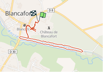
Randonnée Marche de 2,6 km à découvrir à Centre-Val de Loire, Cher, Blancafort. Cette randonnée est proposée par randodan.
Description
WE camping Aubigny<br>
- 03 septembre 2016, ap.m. -<br>
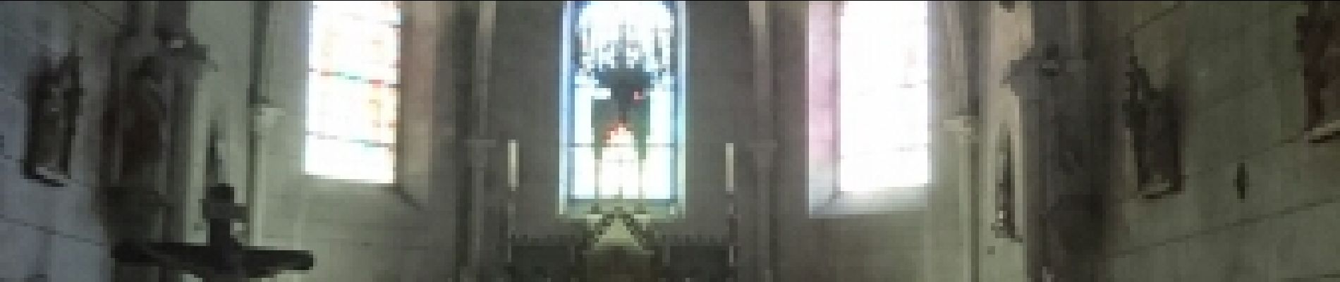
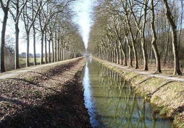
L'après-midi, visite du Château de Blancafort. Puis petite balade le long de l'ancien Canal de la Sauldre (même pas une heure).
Localisation
Pays :
France
Région :
Centre-Val de Loire
Département/Province :
Cher
Commune :
Blancafort
Localité :
Unknown
Départ:(Dec)
Départ:(UTM)
464811 ; 5264436 (31T) N.
Commentaires
Randonnées à proximité
![Randonnée Marche Blancafort - Le Canal de la Sauldre - Blancafort - Photo](https://media.geolcdn.com/t/375/260/ext.jpg?maxdim=2&url=https%3A%2F%2Fservices.sitytrail.com%2FGeolivesWS%2FDownloadMedia.ashx%3FTrailID%3D316756%26Media%3D4668_1.jpg)
![Marche Marche](https://static1.geolcdn.com/sitytour/trail-icons/101.png)
Le Canal de la Sauldre - Blancafort
Marche
Moyen
(1)
Blancafort,
Centre-Val de Loire,
Cher,
France
![](/images/other/stat-length.png)
16,2 km | 17,9 km-effort
4h 0min
![](https://static1.geolcdn.com/siteimages/upload/files/16400158638029165_repeat_loop_refresh_sync_direction_icon.png)
Oui
![Randonnée Cheval Blancafort - Le Canal de la Sauldre - Blancafort - Photo](https://media.geolcdn.com/t/375/260/ext.jpg?maxdim=2&url=https%3A%2F%2Fservices.sitytrail.com%2FGeolivesWS%2FDownloadMedia.ashx%3FTrailID%3D316758%26Media%3D4668_1.jpg)
![Cheval Cheval](https://static1.geolcdn.com/sitytour/trail-icons/300.png)
Le Canal de la Sauldre - Blancafort
Cheval
Difficile
Blancafort,
Centre-Val de Loire,
Cher,
France
![](/images/other/stat-length.png)
16,2 km | 17,9 km-effort
3h 0min
![](https://static1.geolcdn.com/siteimages/upload/files/16400158638029165_repeat_loop_refresh_sync_direction_icon.png)
Oui
![Randonnée V.T.T. Blancafort - Le Canal de la Sauldre - Blancafort - Photo](https://media.geolcdn.com/t/375/260/ext.jpg?maxdim=2&url=https%3A%2F%2Fservices.sitytrail.com%2FGeolivesWS%2FDownloadMedia.ashx%3FTrailID%3D316757%26Media%3D4668_1.jpg)
![V.T.T. V.T.T.](https://static1.geolcdn.com/sitytour/trail-icons/202.png)
Le Canal de la Sauldre - Blancafort
V.T.T.
Moyen
Blancafort,
Centre-Val de Loire,
Cher,
France
![](/images/other/stat-length.png)
16,2 km | 17,9 km-effort
2h 0min
![](https://static1.geolcdn.com/siteimages/upload/files/16400158638029165_repeat_loop_refresh_sync_direction_icon.png)
Oui
![Randonnée Marche Blancafort - Blancafort - Photo](https://media.geolcdn.com/t/375/260/ext.jpg?maxdim=2&url=https%3A%2F%2Fstatic1.geolcdn.com%2Fsiteimages%2Fupload%2Ffiles%2F1553511878bg_sport_marche.png)
![Marche Marche](https://static1.geolcdn.com/sitytour/trail-icons/101.png)
Blancafort
Marche
Très facile
Blancafort,
Centre-Val de Loire,
Cher,
France
![](/images/other/stat-length.png)
9,7 km | 10,6 km-effort
2h 22min
![](https://static1.geolcdn.com/siteimages/upload/files/16400158638029165_repeat_loop_refresh_sync_direction_icon.png)
Oui
![Randonnée Marche Concressault - Ballade dans la campagne du Cher - Photo](https://media.geolcdn.com/t/375/260/ext.jpg?maxdim=2&url=https%3A%2F%2Fstatic1.geolcdn.com%2Fsiteimages%2Fupload%2Ffiles%2F1553511878bg_sport_marche.png)
![Marche Marche](https://static1.geolcdn.com/sitytour/trail-icons/101.png)
Ballade dans la campagne du Cher
Marche
Très facile
Concressault,
Centre-Val de Loire,
Cher,
France
![](/images/other/stat-length.png)
8,9 km | 10,5 km-effort
2h 33min
![](https://static1.geolcdn.com/siteimages/upload/files/16400158638029165_repeat_loop_refresh_sync_direction_icon.png)
Oui
![Randonnée Marche Blancafort - Blancafort 25 04 2021 - Photo](https://media.geolcdn.com/t/375/260/ext.jpg?maxdim=2&url=https%3A%2F%2Fstatic1.geolcdn.com%2Fsiteimages%2Fupload%2Ffiles%2F1553511878bg_sport_marche.png)
![Marche Marche](https://static1.geolcdn.com/sitytour/trail-icons/101.png)
Blancafort 25 04 2021
Marche
Facile
Blancafort,
Centre-Val de Loire,
Cher,
France
![](/images/other/stat-length.png)
10,8 km | 12 km-effort
2h 25min
![](https://static1.geolcdn.com/siteimages/upload/files/16400158638029165_repeat_loop_refresh_sync_direction_icon.png)
Oui
![Randonnée Marche Blancafort - aubigny - Photo](https://media.geolcdn.com/t/375/260/ext.jpg?maxdim=2&url=https%3A%2F%2Fstatic1.geolcdn.com%2Fsiteimages%2Fupload%2Ffiles%2F1553511878bg_sport_marche.png)
![Marche Marche](https://static1.geolcdn.com/sitytour/trail-icons/101.png)
aubigny
Marche
Très facile
Blancafort,
Centre-Val de Loire,
Cher,
France
![](/images/other/stat-length.png)
28 km | 32 km-effort
7h 4min
![](https://static1.geolcdn.com/siteimages/upload/files/16400158638029165_repeat_loop_refresh_sync_direction_icon.png)
Non