![](/images/other/stat-length.png)
![Randonnée Autre activité Orgnac-sur-Vézère - erreur déniv sur courbe niv (Orgnac/Rouffignac) - Photo](https://media.geolcdn.com/t/1900/400/ext.pjpeg?maxdim=2&url=https%3A%2F%2Fstatic1.geolcdn.com%2Fsiteimages%2Fupload%2Ffiles%2F1545311037marcheuse_200dpi.jpg)
erreur déniv sur courbe niv (Orgnac/Rouffignac)
randodan
Utilisateur
![Longueur](/images/other/stat-length.png)
Longueur
1,4 km
![Altitude max](https://static1.geolcdn.com/siteimages/upload/files/1508320355ic_sort_altitude_max_24dp.png)
Altitude max
273 m
![Dénivelé positif](https://static1.geolcdn.com/siteimages/upload/files/1508320355ic_sort_den_pos_24dp.png)
Dénivelé positif
106 m
![Km-Effort](/images/other/stat-length.png)
Km-Effort
2,6 km
![Altitude min](https://static1.geolcdn.com/siteimages/upload/files/1508320355ic_sort_altitude_min_24dp.png)
Altitude min
189 m
![Dénivelé négatif](https://static1.geolcdn.com/siteimages/upload/files/1508320355ic_sort_den_neg_24dp.png)
Dénivelé négatif
48 m
![Boucle](https://static1.geolcdn.com/siteimages/upload/files/16400158638029165_repeat_loop_refresh_sync_direction_icon.png)
Boucle
Non
Date de création :
2016-11-02 00:00:00.0
Dernière modification :
2016-11-02 00:00:00.0
![Autre activité](https://static1.geolcdn.com/sitytour/trail-icons/900.png)
10m
Difficulté : Inconnu
![Scannez ce code QR pour ouvrir la randonnée dans l'application SityTrail](https://capi.geolives.com/qq0zvz2zws4bq2lad0pu/sitytour/trails/627420/qr.png?size=200)
Application GPS de randonnée GRATUITE
À propos
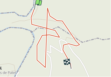
Randonnée Autre activité de 1,4 km à découvrir à Nouvelle-Aquitaine, Corrèze, Orgnac-sur-Vézère. Cette randonnée est proposée par randodan.
Description
le profil fait apparaitre une pointe à 276 m au franchissement de la rivière alors qu'on reste à niveau (~250 m) sur l'IGN
Localisation
Pays :
France
Région :
Nouvelle-Aquitaine
Département/Province :
Corrèze
Commune :
Orgnac-sur-Vézère
Localité :
Unknown
Départ:(Dec)
Départ:(UTM)
376772 ; 5019585 (31T) N.
Commentaires
Randonnées à proximité
![Randonnée Marche Lascaux - La Tine - Lascaux - Photo](https://media.geolcdn.com/t/375/260/ext.jpg?maxdim=2&url=https%3A%2F%2Fservices.sitytrail.com%2FGeolivesWS%2FDownloadMedia.ashx%3FTrailID%3D362600%26Media%3D175ef391-a279-4982-8858-a5aae8bf4699.JPG)
![Marche Marche](https://static1.geolcdn.com/sitytour/trail-icons/101.png)
La Tine - Lascaux
Marche
Moyen
(1)
Lascaux,
Nouvelle-Aquitaine,
Corrèze,
France
![](/images/other/stat-length.png)
8,3 km | 11,9 km-effort
2h 35min
![](https://static1.geolcdn.com/siteimages/upload/files/16400158638029165_repeat_loop_refresh_sync_direction_icon.png)
Oui
![Randonnée Marche Allassac - w-frankrijk-gorges-du-saillant - Photo](https://media.geolcdn.com/t/375/260/ext.jpg?maxdim=2&url=https%3A%2F%2Fstatic1.geolcdn.com%2Fsiteimages%2Fupload%2Ffiles%2F1553511878bg_sport_marche.png)
![Marche Marche](https://static1.geolcdn.com/sitytour/trail-icons/101.png)
w-frankrijk-gorges-du-saillant
Marche
Très facile
(1)
Allassac,
Nouvelle-Aquitaine,
Corrèze,
France
![](/images/other/stat-length.png)
7,1 km | 11,1 km-effort
Inconnu
![](https://static1.geolcdn.com/siteimages/upload/files/16400158638029165_repeat_loop_refresh_sync_direction_icon.png)
Non
![Randonnée Trail Voutezac - 20201226 Saillant 20.5K - Photo](https://media.geolcdn.com/t/375/260/aafc407f-9bee-4f49-b687-53727b6a5044.jpg&format=jpg&maxdim=2)
![Trail Trail](https://static1.geolcdn.com/sitytour/trail-icons/104.png)
20201226 Saillant 20.5K
Trail
Moyen
Voutezac,
Nouvelle-Aquitaine,
Corrèze,
France
![](/images/other/stat-length.png)
21 km | 31 km-effort
3h 22min
![](https://static1.geolcdn.com/siteimages/upload/files/16400158638029165_repeat_loop_refresh_sync_direction_icon.png)
Oui
![Marche Marche](https://static1.geolcdn.com/sitytour/trail-icons/101.png)
Estivaux_Le Saillant-Gorges de la Vézère
Marche
Difficile
Estivaux,
Nouvelle-Aquitaine,
Corrèze,
France
![](/images/other/stat-length.png)
20 km | 30 km-effort
6h 0min
![](https://static1.geolcdn.com/siteimages/upload/files/16400158638029165_repeat_loop_refresh_sync_direction_icon.png)
Oui
![Randonnée Marche Voutezac - Le Saillant - Vallée de la Vézère - Photo](https://media.geolcdn.com/t/375/260/ext.jpg?maxdim=2&url=https%3A%2F%2Fstatic1.geolcdn.com%2Fsiteimages%2Fupload%2Ffiles%2F1553511878bg_sport_marche.png)
![Marche Marche](https://static1.geolcdn.com/sitytour/trail-icons/101.png)
Le Saillant - Vallée de la Vézère
Marche
Très facile
(1)
Voutezac,
Nouvelle-Aquitaine,
Corrèze,
France
![](/images/other/stat-length.png)
9,3 km | 14 km-effort
3h 3min
![](https://static1.geolcdn.com/siteimages/upload/files/16400158638029165_repeat_loop_refresh_sync_direction_icon.png)
Oui
![Randonnée Marche Allassac - Boucle du vieux Saillant - Photo](https://media.geolcdn.com/t/375/260/ext.jpg?maxdim=2&url=https%3A%2F%2Fservices.sitytrail.com%2FGeolivesWS%2FDownloadMedia.ashx%3FTrailID%3D831256%26Media%3De7220420-f8f1-4549-a9ee-5307c0697031.JPG)
![Marche Marche](https://static1.geolcdn.com/sitytour/trail-icons/101.png)
Boucle du vieux Saillant
Marche
Très facile
Allassac,
Nouvelle-Aquitaine,
Corrèze,
France
![](/images/other/stat-length.png)
3 km | 3,8 km-effort
45min
![](https://static1.geolcdn.com/siteimages/upload/files/16400158638029165_repeat_loop_refresh_sync_direction_icon.png)
Oui
![Randonnée Marche Voutezac - Ayen-160623 - Ceyrat-FontaineCrozes - Photo](https://media.geolcdn.com/t/375/260/ext.jpg?maxdim=2&url=https%3A%2F%2Fservices.sitytrail.com%2FGeolivesWS%2FDownloadMedia.ashx%3FTrailID%3D588114%26Media%3Dfix__20160623115501.jpg)
![Marche Marche](https://static1.geolcdn.com/sitytour/trail-icons/101.png)
Ayen-160623 - Ceyrat-FontaineCrozes
Marche
Moyen
Voutezac,
Nouvelle-Aquitaine,
Corrèze,
France
![](/images/other/stat-length.png)
7,5 km | 10,7 km-effort
2h 35min
![](https://static1.geolcdn.com/siteimages/upload/files/16400158638029165_repeat_loop_refresh_sync_direction_icon.png)
Oui
![Randonnée Marche Voutezac - Les coteaux de Vertougit - Voutezac - Photo](https://media.geolcdn.com/t/375/260/ext.jpg?maxdim=2&url=https%3A%2F%2Fservices.sitytrail.com%2FGeolivesWS%2FDownloadMedia.ashx%3FTrailID%3D318028%26Media%3D17491_3.jpg)
![Marche Marche](https://static1.geolcdn.com/sitytour/trail-icons/101.png)
Les coteaux de Vertougit - Voutezac
Marche
Moyen
Voutezac,
Nouvelle-Aquitaine,
Corrèze,
France
![](/images/other/stat-length.png)
10,9 km | 15,3 km-effort
3h 30min
![](https://static1.geolcdn.com/siteimages/upload/files/16400158638029165_repeat_loop_refresh_sync_direction_icon.png)
Oui
![Randonnée Marche Voutezac - La fontaine des Crozes - Voutezac - Photo](https://media.geolcdn.com/t/375/260/ext.jpg?maxdim=2&url=https%3A%2F%2Fservices.sitytrail.com%2FGeolivesWS%2FDownloadMedia.ashx%3FTrailID%3D318027%26Media%3D17490_3.jpg)
![Marche Marche](https://static1.geolcdn.com/sitytour/trail-icons/101.png)
La fontaine des Crozes - Voutezac
Marche
Difficile
(1)
Voutezac,
Nouvelle-Aquitaine,
Corrèze,
France
![](/images/other/stat-length.png)
11,8 km | 16,7 km-effort
3h 0min
![](https://static1.geolcdn.com/siteimages/upload/files/16400158638029165_repeat_loop_refresh_sync_direction_icon.png)
Oui