![](/images/other/stat-length.png)
![Randonnée Marche Balloy - la petite seine - Photo](https://media.geolcdn.com/t/1900/400/ext.pjpeg?maxdim=2&url=https%3A%2F%2Fstatic1.geolcdn.com%2Fsiteimages%2Fupload%2Ffiles%2F1553511878bg_sport_marche.png)
la petite seine
micheljannot
Utilisateur
![Longueur](/images/other/stat-length.png)
Longueur
9,8 km
![Altitude max](https://static1.geolcdn.com/siteimages/upload/files/1508320355ic_sort_altitude_max_24dp.png)
Altitude max
57 m
![Dénivelé positif](https://static1.geolcdn.com/siteimages/upload/files/1508320355ic_sort_den_pos_24dp.png)
Dénivelé positif
51 m
![Km-Effort](/images/other/stat-length.png)
Km-Effort
10,5 km
![Altitude min](https://static1.geolcdn.com/siteimages/upload/files/1508320355ic_sort_altitude_min_24dp.png)
Altitude min
47 m
![Dénivelé négatif](https://static1.geolcdn.com/siteimages/upload/files/1508320355ic_sort_den_neg_24dp.png)
Dénivelé négatif
51 m
![Boucle](https://static1.geolcdn.com/siteimages/upload/files/16400158638029165_repeat_loop_refresh_sync_direction_icon.png)
Boucle
Oui
Date de création :
2016-09-07 00:00:00.0
Dernière modification :
2016-09-07 00:00:00.0
![Marche](https://static1.geolcdn.com/sitytour/trail-icons/101.png)
2h13
Difficulté : Facile
![Scannez ce code QR pour ouvrir la randonnée dans l'application SityTrail](https://capi.geolives.com/qq0zvz2zws4bq2lad0pu/sitytour/trails/627021/qr.png?size=200)
Application GPS de randonnée GRATUITE
À propos
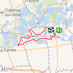
Randonnée Marche de 9,8 km à découvrir à Île-de-France, Seine-et-Marne, Balloy. Cette randonnée est proposée par micheljannot.
Description
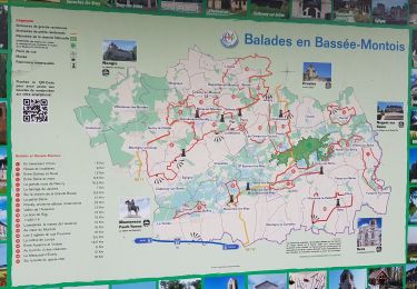
PR n°18 de "la Seine-et-Marne à pied"
à 15 km à l'est de Montereau
se garer cent mètres au sud de l'église de Balloy
Localisation
Pays :
France
Région :
Île-de-France
Département/Province :
Seine-et-Marne
Commune :
Balloy
Localité :
Unknown
Départ:(Dec)
Départ:(UTM)
510867 ; 5360578 (31U) N.
Commentaires
Randonnées à proximité
![Randonnée Randonnée équestre Balloy - belloy - Photo](https://media.geolcdn.com/t/375/260/875ba4e1-52d7-4c14-90f4-ae7d1db63c34.jpg&format=jpg&maxdim=2)
![Randonnée équestre Randonnée équestre](https://static1.geolcdn.com/sitytour/trail-icons/301.png)
belloy
Randonnée équestre
Facile
Balloy,
Île-de-France,
Seine-et-Marne,
France
![](/images/other/stat-length.png)
17,2 km | 18,4 km-effort
3h 55min
![](https://static1.geolcdn.com/siteimages/upload/files/16400158638029165_repeat_loop_refresh_sync_direction_icon.png)
Oui
![Randonnée Marche Misy-sur-Yonne - JC 03 Misy sur Yonne Les sablières - Photo](https://media.geolcdn.com/t/375/260/836c8c29-92cc-4234-9bf1-467fa8145080.jpg&format=jpg&maxdim=2)
![Marche Marche](https://static1.geolcdn.com/sitytour/trail-icons/101.png)
JC 03 Misy sur Yonne Les sablières
Marche
Difficile
Misy-sur-Yonne,
Île-de-France,
Seine-et-Marne,
France
![](/images/other/stat-length.png)
22 km | 23 km-effort
4h 33min
![](https://static1.geolcdn.com/siteimages/upload/files/16400158638029165_repeat_loop_refresh_sync_direction_icon.png)
Oui
![Randonnée Marche Misy-sur-Yonne - Misy sur Yonne 221120 - Photo](https://media.geolcdn.com/t/375/260/ext.jpg?maxdim=2&url=https%3A%2F%2Fstatic1.geolcdn.com%2Fsiteimages%2Fupload%2Ffiles%2F1553511878bg_sport_marche.png)
![Marche Marche](https://static1.geolcdn.com/sitytour/trail-icons/101.png)
Misy sur Yonne 221120
Marche
Très facile
Misy-sur-Yonne,
Île-de-France,
Seine-et-Marne,
France
![](/images/other/stat-length.png)
10,3 km | 11 km-effort
3h 10min
![](https://static1.geolcdn.com/siteimages/upload/files/16400158638029165_repeat_loop_refresh_sync_direction_icon.png)
Oui
![Randonnée Marche Balloy - SityTrail - Balloy am - Photo](https://media.geolcdn.com/t/375/260/ext.jpg?maxdim=2&url=https%3A%2F%2Fstatic1.geolcdn.com%2Fsiteimages%2Fupload%2Ffiles%2F1553511878bg_sport_marche.png)
![Marche Marche](https://static1.geolcdn.com/sitytour/trail-icons/101.png)
SityTrail - Balloy am
Marche
Moyen
Balloy,
Île-de-France,
Seine-et-Marne,
France
![](/images/other/stat-length.png)
10,9 km | 11,6 km-effort
2h 35min
![](https://static1.geolcdn.com/siteimages/upload/files/16400158638029165_repeat_loop_refresh_sync_direction_icon.png)
Oui
![Randonnée A pied Balloy - Balloy am - Photo](https://media.geolcdn.com/t/375/260/ext.jpg?maxdim=2&url=https%3A%2F%2Fstatic1.geolcdn.com%2Fsiteimages%2Fupload%2Ffiles%2F1545311037marcheuse_200dpi.jpg)
![A pied A pied](https://static1.geolcdn.com/sitytour/trail-icons/100.png)
Balloy am
A pied
Très facile
Balloy,
Île-de-France,
Seine-et-Marne,
France
![](/images/other/stat-length.png)
9,3 km | 10 km-effort
Inconnu
![](https://static1.geolcdn.com/siteimages/upload/files/16400158638029165_repeat_loop_refresh_sync_direction_icon.png)
Oui
![Randonnée Marche Balloy - PR11 - La Petite Seine - Photo](https://media.geolcdn.com/t/375/260/ext.jpg?maxdim=2&url=https%3A%2F%2Fstatic1.geolcdn.com%2Fsiteimages%2Fupload%2Ffiles%2F1553511878bg_sport_marche.png)
![Marche Marche](https://static1.geolcdn.com/sitytour/trail-icons/101.png)
PR11 - La Petite Seine
Marche
Très facile
Balloy,
Île-de-France,
Seine-et-Marne,
France
![](/images/other/stat-length.png)
10,1 km | 10,7 km-effort
2h 0min
![](https://static1.geolcdn.com/siteimages/upload/files/16400158638029165_repeat_loop_refresh_sync_direction_icon.png)
Oui
![Randonnée Marche nordique La Tombe - rando sur GRAVON - Photo](https://media.geolcdn.com/t/375/260/ext.jpg?maxdim=2&url=https%3A%2F%2Fstatic1.geolcdn.com%2Fsiteimages%2Fupload%2Ffiles%2F1545311037marcheuse_200dpi.jpg)
![Marche nordique Marche nordique](https://static1.geolcdn.com/sitytour/trail-icons/102.png)
rando sur GRAVON
Marche nordique
Moyen
La Tombe,
Île-de-France,
Seine-et-Marne,
France
![](/images/other/stat-length.png)
18,1 km | 19,1 km-effort
Inconnu
![](https://static1.geolcdn.com/siteimages/upload/files/16400158638029165_repeat_loop_refresh_sync_direction_icon.png)
Oui
![Randonnée Marche Balloy - SityTrail - balloy matin Rec - Photo](https://media.geolcdn.com/t/375/260/ext.jpg?maxdim=2&url=https%3A%2F%2Fstatic1.geolcdn.com%2Fsiteimages%2Fupload%2Ffiles%2F1553511878bg_sport_marche.png)
![Marche Marche](https://static1.geolcdn.com/sitytour/trail-icons/101.png)
SityTrail - balloy matin Rec
Marche
Moyen
Balloy,
Île-de-France,
Seine-et-Marne,
France
![](/images/other/stat-length.png)
10,4 km | 11 km-effort
2h 28min
![](https://static1.geolcdn.com/siteimages/upload/files/16400158638029165_repeat_loop_refresh_sync_direction_icon.png)
Oui
![Randonnée Marche Balloy - balloy matin Rec - Photo](https://media.geolcdn.com/t/375/260/ext.jpg?maxdim=2&url=https%3A%2F%2Fstatic1.geolcdn.com%2Fsiteimages%2Fupload%2Ffiles%2F1553511878bg_sport_marche.png)
![Marche Marche](https://static1.geolcdn.com/sitytour/trail-icons/101.png)
balloy matin Rec
Marche
Très facile
Balloy,
Île-de-France,
Seine-et-Marne,
France
![](/images/other/stat-length.png)
10,4 km | 11 km-effort
1h 14min
![](https://static1.geolcdn.com/siteimages/upload/files/16400158638029165_repeat_loop_refresh_sync_direction_icon.png)
Oui
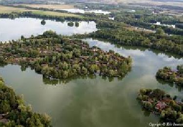
partie en bord de Seine très pittoresque