![](/images/other/stat-length.png)
![Randonnée Marche Sint-Michielsgestel - klein stukje langs de Dommel bij Gemonde - Photo](https://media.geolcdn.com/t/1900/400/ext.pjpeg?maxdim=2&url=https%3A%2F%2Fstatic1.geolcdn.com%2Fsiteimages%2Fupload%2Ffiles%2F1553511878bg_sport_marche.png)
klein stukje langs de Dommel bij Gemonde
jmbertens
Utilisateur
![Longueur](/images/other/stat-length.png)
Longueur
4,3 km
![Altitude max](https://static1.geolcdn.com/siteimages/upload/files/1508320355ic_sort_altitude_max_24dp.png)
Altitude max
9 m
![Dénivelé positif](https://static1.geolcdn.com/siteimages/upload/files/1508320355ic_sort_den_pos_24dp.png)
Dénivelé positif
15 m
![Km-Effort](/images/other/stat-length.png)
Km-Effort
4,5 km
![Altitude min](https://static1.geolcdn.com/siteimages/upload/files/1508320355ic_sort_altitude_min_24dp.png)
Altitude min
3 m
![Dénivelé négatif](https://static1.geolcdn.com/siteimages/upload/files/1508320355ic_sort_den_neg_24dp.png)
Dénivelé négatif
15 m
![Boucle](https://static1.geolcdn.com/siteimages/upload/files/16400158638029165_repeat_loop_refresh_sync_direction_icon.png)
Boucle
Oui
Date de création :
2016-08-20 00:00:00.0
Dernière modification :
2016-08-20 00:00:00.0
![Marche](https://static1.geolcdn.com/sitytour/trail-icons/101.png)
1h04
Difficulté : Très facile
![Scannez ce code QR pour ouvrir la randonnée dans l'application SityTrail](https://capi.geolives.com/qq0zvz2zws4bq2lad0pu/sitytour/trails/617818/qr.png?size=200)
Application GPS de randonnée GRATUITE
À propos
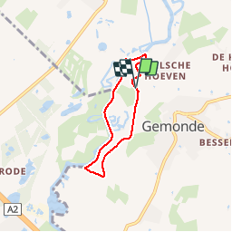
Randonnée Marche de 4,3 km à découvrir à Brabant-Septentrional, Inconnu, Sint-Michielsgestel. Cette randonnée est proposée par jmbertens.
Description
Een klein stukje langs de Dommel tussen Gemonde en Sint Michielsgestel. Schitterende uitzichten over het water en landgoederen. Terug tussen de maisvelden over zandpaden.
Localisation
Pays :
Pays-Bas
Région :
Brabant-Septentrional
Département/Province :
Inconnu
Commune :
Sint-Michielsgestel
Localité :
Unknown
Départ:(Dec)
Départ:(UTM)
662518 ; 5721740 (31U) N.
Commentaires
Randonnées à proximité
![Randonnée A pied Sint-Michielsgestel - Vossenholenpad - Photo](https://media.geolcdn.com/t/375/260/dev_95ce72be-0826-488f-921d-734b2b2ce378.jpeg&format=jpg&maxdim=2)
![A pied A pied](https://static1.geolcdn.com/sitytour/trail-icons/100.png)
Vossenholenpad
A pied
Facile
Sint-Michielsgestel,
Brabant-Septentrional,
Inconnu,
Pays-Bas
![](/images/other/stat-length.png)
6,4 km | 6,8 km-effort
1h 32min
![](https://static1.geolcdn.com/siteimages/upload/files/16400158638029165_repeat_loop_refresh_sync_direction_icon.png)
Oui
![Randonnée Vélo Vught - f-nbrabant-timmerman-legal-6 - Photo](https://media.geolcdn.com/t/375/260/ext.jpg?maxdim=2&url=https%3A%2F%2Fstatic1.geolcdn.com%2Fsiteimages%2Fupload%2Ffiles%2F1524743154velo.jpg)
![Vélo Vélo](https://static1.geolcdn.com/sitytour/trail-icons/200.png)
f-nbrabant-timmerman-legal-6
Vélo
Très facile
Vught,
Brabant-Septentrional,
Inconnu,
Pays-Bas
![](/images/other/stat-length.png)
80 km | 85 km-effort
Inconnu
![](https://static1.geolcdn.com/siteimages/upload/files/16400158638029165_repeat_loop_refresh_sync_direction_icon.png)
Oui
![Randonnée Vélo Boxtel - f-nbrabant-boxtel - Photo](https://media.geolcdn.com/t/375/260/ext.jpg?maxdim=2&url=https%3A%2F%2Fstatic1.geolcdn.com%2Fsiteimages%2Fupload%2Ffiles%2F1524743154velo.jpg)
![Vélo Vélo](https://static1.geolcdn.com/sitytour/trail-icons/200.png)
f-nbrabant-boxtel
Vélo
Très facile
Boxtel,
Brabant-Septentrional,
Inconnu,
Pays-Bas
![](/images/other/stat-length.png)
44 km | 47 km-effort
Inconnu
![](https://static1.geolcdn.com/siteimages/upload/files/16400158638029165_repeat_loop_refresh_sync_direction_icon.png)
Oui
![Randonnée V.T.T. Meierijstad - m-nbrabant-mtbroute-gemonde - Photo](https://media.geolcdn.com/t/375/260/ext.jpg?maxdim=2&url=https%3A%2F%2Fstatic1.geolcdn.com%2Fsiteimages%2Fupload%2Ffiles%2F1524743154velo.jpg)
![V.T.T. V.T.T.](https://static1.geolcdn.com/sitytour/trail-icons/202.png)
m-nbrabant-mtbroute-gemonde
V.T.T.
Très facile
Meierijstad,
Brabant-Septentrional,
Inconnu,
Pays-Bas
![](/images/other/stat-length.png)
30 km | 33 km-effort
Inconnu
![](https://static1.geolcdn.com/siteimages/upload/files/16400158638029165_repeat_loop_refresh_sync_direction_icon.png)
Oui
![Randonnée Marche Meierijstad - w-nbrabant-rond-olland - Photo](https://media.geolcdn.com/t/375/260/ext.jpg?maxdim=2&url=https%3A%2F%2Fstatic1.geolcdn.com%2Fsiteimages%2Fupload%2Ffiles%2F1553511878bg_sport_marche.png)
![Marche Marche](https://static1.geolcdn.com/sitytour/trail-icons/101.png)
w-nbrabant-rond-olland
Marche
Très facile
Meierijstad,
Brabant-Septentrional,
Inconnu,
Pays-Bas
![](/images/other/stat-length.png)
9,4 km | 10,1 km-effort
Inconnu
![](https://static1.geolcdn.com/siteimages/upload/files/16400158638029165_repeat_loop_refresh_sync_direction_icon.png)
Oui
![Randonnée Marche Boxtel - w-nbrabant-ns-wandeling-kampina - Photo](https://media.geolcdn.com/t/375/260/ext.jpg?maxdim=2&url=https%3A%2F%2Fstatic1.geolcdn.com%2Fsiteimages%2Fupload%2Ffiles%2F1553511878bg_sport_marche.png)
![Marche Marche](https://static1.geolcdn.com/sitytour/trail-icons/101.png)
w-nbrabant-ns-wandeling-kampina
Marche
Très facile
Boxtel,
Brabant-Septentrional,
Inconnu,
Pays-Bas
![](/images/other/stat-length.png)
17 km | 18,1 km-effort
Inconnu
![](https://static1.geolcdn.com/siteimages/upload/files/16400158638029165_repeat_loop_refresh_sync_direction_icon.png)
Non
![Randonnée Marche Sint-Michielsgestel - Noord-Brabant - Wandeling Haanwijk - Photo](https://media.geolcdn.com/t/375/260/ext.jpg?maxdim=2&url=https%3A%2F%2Fstatic1.geolcdn.com%2Fsiteimages%2Fupload%2Ffiles%2F1553511878bg_sport_marche.png)
![Marche Marche](https://static1.geolcdn.com/sitytour/trail-icons/101.png)
Noord-Brabant - Wandeling Haanwijk
Marche
Très facile
Sint-Michielsgestel,
Brabant-Septentrional,
Inconnu,
Pays-Bas
![](/images/other/stat-length.png)
3,3 km | 3,6 km-effort
Inconnu
![](https://static1.geolcdn.com/siteimages/upload/files/16400158638029165_repeat_loop_refresh_sync_direction_icon.png)
Oui
![Randonnée Marche Boxtel - Liempde - Photo](https://media.geolcdn.com/t/375/260/ext.jpg?maxdim=2&url=https%3A%2F%2Fstatic1.geolcdn.com%2Fsiteimages%2Fupload%2Ffiles%2F1553511878bg_sport_marche.png)
![Marche Marche](https://static1.geolcdn.com/sitytour/trail-icons/101.png)
Liempde
Marche
Moyen
Boxtel,
Brabant-Septentrional,
Inconnu,
Pays-Bas
![](/images/other/stat-length.png)
7,1 km | 7,7 km-effort
6h 45min
![](https://static1.geolcdn.com/siteimages/upload/files/16400158638029165_repeat_loop_refresh_sync_direction_icon.png)
Oui
![Randonnée Marche Boxtel - 5.916 Boxtel - Oisterwijk - Photo](https://media.geolcdn.com/t/375/260/ext.jpg?maxdim=2&url=https%3A%2F%2Fstatic1.geolcdn.com%2Fsiteimages%2Fupload%2Ffiles%2F1553511878bg_sport_marche.png)
![Marche Marche](https://static1.geolcdn.com/sitytour/trail-icons/101.png)
5.916 Boxtel - Oisterwijk
Marche
Moyen
Boxtel,
Brabant-Septentrional,
Inconnu,
Pays-Bas
![](/images/other/stat-length.png)
15,7 km | 16,9 km-effort
3h 50min
![](https://static1.geolcdn.com/siteimages/upload/files/16400158638029165_repeat_loop_refresh_sync_direction_icon.png)
Non