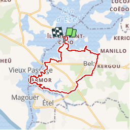
![](/images/other/stat-length.png)
![Randonnée Marche Belz - St-Cado_Etel - Photo](https://media.geolcdn.com/t/1900/400/ext.pjpeg?maxdim=2&url=https%3A%2F%2Fstatic1.geolcdn.com%2Fsiteimages%2Fupload%2Ffiles%2F1553511878bg_sport_marche.png)
St-Cado_Etel
neoroll44
Utilisateur
![Longueur](/images/other/stat-length.png)
![Altitude max](https://static1.geolcdn.com/siteimages/upload/files/1508320355ic_sort_altitude_max_24dp.png)
![Dénivelé positif](https://static1.geolcdn.com/siteimages/upload/files/1508320355ic_sort_den_pos_24dp.png)
![Km-Effort](/images/other/stat-length.png)
![Altitude min](https://static1.geolcdn.com/siteimages/upload/files/1508320355ic_sort_altitude_min_24dp.png)
![Dénivelé négatif](https://static1.geolcdn.com/siteimages/upload/files/1508320355ic_sort_den_neg_24dp.png)
![Boucle](https://static1.geolcdn.com/siteimages/upload/files/16400158638029165_repeat_loop_refresh_sync_direction_icon.png)
![Marche](https://static1.geolcdn.com/sitytour/trail-icons/101.png)
3h18
Difficulté : Moyen
![Scannez ce code QR pour ouvrir la randonnée dans l'application SityTrail](https://capi.geolives.com/qq0zvz2zws4bq2lad0pu/sitytour/trails/617192/qr.png?size=200)
Application GPS de randonnée GRATUITE
À propos
Randonnée Marche de 13,5 km à découvrir à Bretagne, Morbihan, Belz. Cette randonnée est proposée par neoroll44.
Description
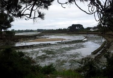
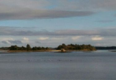
Garer sa voiture sur un des parkings aménagés à Saint Cado. La randonnée démarre sur le parking en face de l'ile. Prendre sur la gauche le long de la mer (on fera le tour de l'ile de Saint Cado à la fin de la boucle). Suivre la route à gauche le long de la mer. Au rond point prendre à droite. A l'intersection suivante prendre tout droit, on va suivre le GR. Prendre à droite, puis à gauche (rue Marchelan). Avant la route prendre à droite (sentier côtier). Continuer le sentier côtier à gauche. Passer sous le Pont Lorois puis traverser Porh Niscop tout droit. Continuer le sentier côtier. A la sortie du sentier prendre le chemin à droite et tout de suite un chemin à droite. Suivre Le Bignac. A la sortie du sentier, Moulin de Bignac, prendre la route en face, puis la route sur la gauche (montée). Traverser la D16 et prendre le chemin légèrement à gauche (direction Kergallan).
A Kergallan prendre le chemin à gauche. Traverser la D781 direction le Bourg. A la sortie du chemin prendre à droite (direction Le Pussic). Traverser la route. Après la déchetterie prendre à gauche (direction Kercadoret) et à la sortie du chemin prendre la route à gauche.
Attention!!! traverser la route, direction Kervilaine.
Avant la digue prendre le chemin à gauche.
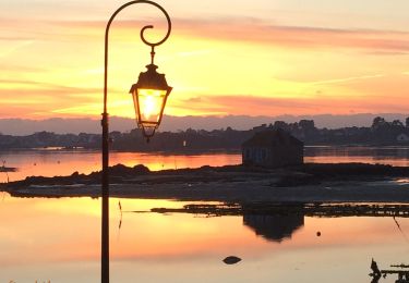
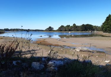
Après la Pointe du Perche prendre la route à gauche puis la 3 ème route à droite (passer devant un dolmen que l'on laisse sur sa gauche). Prendre le chemin à droite (le long de la mer, attention à marée haute passage délicat, prendre la route). Arriver sur un parking, prendre le chemin le long de la côte. Prendre le pont qui rentre dans Saint Cado et faire le tour de l'ile. Prendre la rue à gauche jusqu'à un chemin marqué sans issu et longer la côte (attention à la marée la fin du tour peut être délicat). Sinon revenir et découvrir le village (église, calvaire et fontaine de Saint Cado).
Ressortir de l'ile et retrouver le parking en face de l'ile.
Localisation
Commentaires
Randonnées à proximité
![Randonnée Marche nordique Plouhinec - D'Etel au Pont Laurois par les deux côtés de la Ria - Photo](https://media.geolcdn.com/t/375/260/ext.jpg?maxdim=2&url=https%3A%2F%2Fservices.sitytrail.com%2FGeolivesWS%2FDownloadMedia.ashx%3FTrailID%3D323717%26Media%3Dfix__20140713124707.jpg)
![Marche nordique Marche nordique](https://static1.geolcdn.com/sitytour/trail-icons/102.png)
Marche nordique
![](/images/other/stat-length.png)
![](https://static1.geolcdn.com/siteimages/upload/files/16400158638029165_repeat_loop_refresh_sync_direction_icon.png)
![Randonnée Marche Plouhinec - PR_56_Plouhinec_AA_01_Circuit1b_La-Ria-Par-Les-Pinedes_20200712 - Photo](https://media.geolcdn.com/t/375/260/1d672734-99d3-43b8-9472-2acec23bab09.jpg&format=jpg&maxdim=2)
![Marche Marche](https://static1.geolcdn.com/sitytour/trail-icons/101.png)
Marche
![](/images/other/stat-length.png)
![](https://static1.geolcdn.com/siteimages/upload/files/16400158638029165_repeat_loop_refresh_sync_direction_icon.png)
![Randonnée Marche Plouhinec - Rivière d'Etel - Photo](https://media.geolcdn.com/t/375/260/ext.jpg?maxdim=2&url=https%3A%2F%2Fservices.sitytrail.com%2FGeolivesWS%2FDownloadMedia.ashx%3FTrailID%3D691090%26Media%3Dfix__20170128155839.jpg)
![Marche Marche](https://static1.geolcdn.com/sitytour/trail-icons/101.png)
Marche
![](/images/other/stat-length.png)
![](https://static1.geolcdn.com/siteimages/upload/files/16400158638029165_repeat_loop_refresh_sync_direction_icon.png)
![Randonnée Marche Étel - bignac - Photo](https://media.geolcdn.com/t/375/260/ext.jpg?maxdim=2&url=https%3A%2F%2Fservices.sitytrail.com%2FGeolivesWS%2FDownloadMedia.ashx%3FTrailID%3D153357%26Media%3D20120913152815.jpeg)
![Marche Marche](https://static1.geolcdn.com/sitytour/trail-icons/101.png)
![Randonnée Marche nordique Belz - Bignac 05-11-17 . - Photo](https://media.geolcdn.com/t/375/260/ext.jpg?maxdim=2&url=https%3A%2F%2Fservices.sitytrail.com%2FGeolivesWS%2FDownloadMedia.ashx%3FTrailID%3D857287%26Media%3Dfix__20171104144738.jpg)
![Marche nordique Marche nordique](https://static1.geolcdn.com/sitytour/trail-icons/102.png)
Marche nordique
![](/images/other/stat-length.png)
![](https://static1.geolcdn.com/siteimages/upload/files/16400158638029165_repeat_loop_refresh_sync_direction_icon.png)
![Randonnée Marche Belz - L 'Île de Saint Cado (07- 06-15 - Photo](https://media.geolcdn.com/t/375/260/ext.jpg?maxdim=2&url=https%3A%2F%2Fservices.sitytrail.com%2FGeolivesWS%2FDownloadMedia.ashx%3FTrailID%3D430884%26Media%3Dfix__20150607180503.jpg)
![Marche Marche](https://static1.geolcdn.com/sitytour/trail-icons/101.png)
Marche
![](/images/other/stat-length.png)
![](https://static1.geolcdn.com/siteimages/upload/files/16400158638029165_repeat_loop_refresh_sync_direction_icon.png)
![Randonnée Autre activité Étel - D'Etel au Narbon - Photo](https://media.geolcdn.com/t/375/260/ext.jpg?maxdim=2&url=https%3A%2F%2Fstatic1.geolcdn.com%2Fsiteimages%2Fupload%2Ffiles%2F1545311037marcheuse_200dpi.jpg)
![Autre activité Autre activité](https://static1.geolcdn.com/sitytour/trail-icons/900.png)
Autre activité
![](/images/other/stat-length.png)
![](https://static1.geolcdn.com/siteimages/upload/files/16400158638029165_repeat_loop_refresh_sync_direction_icon.png)
![Randonnée Marche Plouhinec - tour ria etel bretagne - Photo](https://media.geolcdn.com/t/375/260/ext.jpg?maxdim=2&url=https%3A%2F%2Fservices.sitytrail.com%2FGeolivesWS%2FDownloadMedia.ashx%3FTrailID%3D329248%26Media%3Dfix__20140730144510.jpg)
![Marche Marche](https://static1.geolcdn.com/sitytour/trail-icons/101.png)
Marche
![](/images/other/stat-length.png)
![](https://static1.geolcdn.com/siteimages/upload/files/16400158638029165_repeat_loop_refresh_sync_direction_icon.png)
![Randonnée A pied Belz - Etre douar ar mor - Photo](https://media.geolcdn.com/t/375/260/e888e374-1c52-424c-bf66-49a872f27ec5.jpeg&format=jpg&maxdim=2)
![A pied A pied](https://static1.geolcdn.com/sitytour/trail-icons/100.png)