![](/images/other/stat-length.png)
![Randonnée Marche Saint-Gildas-de-Rhuys - Tour de Sarzeau par le GR 34 - Photo](https://media.geolcdn.com/t/1900/400/ext.pjpeg?maxdim=2&url=https%3A%2F%2Fservices.sitytrail.com%2FGeolivesWS%2FDownloadMedia.ashx%3FTrailID%3D614509%26Media%3Dfix__20160726174439.jpg)
Tour de Sarzeau par le GR 34
Axelloceane
Utilisateur
![Longueur](/images/other/stat-length.png)
Longueur
29 km
![Altitude max](https://static1.geolcdn.com/siteimages/upload/files/1508320355ic_sort_altitude_max_24dp.png)
Altitude max
20 m
![Dénivelé positif](https://static1.geolcdn.com/siteimages/upload/files/1508320355ic_sort_den_pos_24dp.png)
Dénivelé positif
238 m
![Km-Effort](/images/other/stat-length.png)
Km-Effort
33 km
![Altitude min](https://static1.geolcdn.com/siteimages/upload/files/1508320355ic_sort_altitude_min_24dp.png)
Altitude min
-1 m
![Dénivelé négatif](https://static1.geolcdn.com/siteimages/upload/files/1508320355ic_sort_den_neg_24dp.png)
Dénivelé négatif
229 m
![Boucle](https://static1.geolcdn.com/siteimages/upload/files/16400158638029165_repeat_loop_refresh_sync_direction_icon.png)
Boucle
Non
Date de création :
2016-10-05 00:00:00.0
Dernière modification :
2016-10-05 00:00:00.0
![Marche](https://static1.geolcdn.com/sitytour/trail-icons/101.png)
7h17
Difficulté : Facile
![Scannez ce code QR pour ouvrir la randonnée dans l'application SityTrail](https://capi.geolives.com/qq0zvz2zws4bq2lad0pu/sitytour/trails/614509/qr.png?size=200)
Application GPS de randonnée GRATUITE
À propos
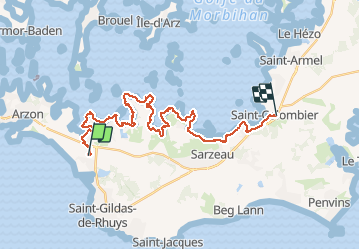
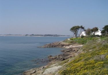
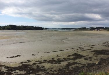
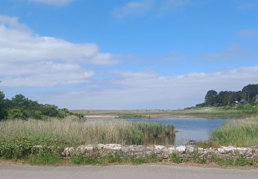
Randonnée Marche de 29 km à découvrir à Bretagne, Morbihan, Saint-Gildas-de-Rhuys. Cette randonnée est proposée par Axelloceane.
Description
Départ du camping et rejoindre le GR 34 par Le Net ensuite suivre l'itinéraire du GR 34 avec une vue sous différents angles du golfe.A St Colombier retour par le bus.
Localisation
Pays :
France
Région :
Bretagne
Département/Province :
Morbihan
Commune :
Saint-Gildas-de-Rhuys
Localité :
Unknown
Départ:(Dec)
Départ:(UTM)
511304 ; 5263887 (30T) N.
Commentaires
Randonnées à proximité
![Randonnée Marche Arzon - tour d'Arzon - Photo](https://media.geolcdn.com/t/375/260/8d2666dc-76b6-4531-82fb-267206fdbff7.jpg&format=jpg&maxdim=2)
![Marche Marche](https://static1.geolcdn.com/sitytour/trail-icons/101.png)
tour d'Arzon
Marche
Facile
(1)
Arzon,
Bretagne,
Morbihan,
France
![](/images/other/stat-length.png)
12,6 km | 14,1 km-effort
3h 19min
![](https://static1.geolcdn.com/siteimages/upload/files/16400158638029165_repeat_loop_refresh_sync_direction_icon.png)
Oui
![Randonnée Marche Arzon - Tour du Golfe du Morbihan - 01 - Arzon - Photo](https://media.geolcdn.com/t/375/260/ext.jpg?maxdim=2&url=https%3A%2F%2Fservices.sitytrail.com%2FGeolivesWS%2FDownloadMedia.ashx%3FTrailID%3D109031%26Media%3D2997_2.jpg)
![Marche Marche](https://static1.geolcdn.com/sitytour/trail-icons/101.png)
Tour du Golfe du Morbihan - 01 - Arzon
Marche
Moyen
(1)
Arzon,
Bretagne,
Morbihan,
France
![](/images/other/stat-length.png)
18,9 km | 21 km-effort
4h 0min
![](https://static1.geolcdn.com/siteimages/upload/files/16400158638029165_repeat_loop_refresh_sync_direction_icon.png)
Non
![Randonnée Marche Arzon - Tour du Golfe - Arzon - Photo](https://media.geolcdn.com/t/375/260/ext.jpg?maxdim=2&url=https%3A%2F%2Fservices.sitytrail.com%2FGeolivesWS%2FDownloadMedia.ashx%3FTrailID%3D107071%26Media%3D11890_2.jpg)
![Marche Marche](https://static1.geolcdn.com/sitytour/trail-icons/101.png)
Tour du Golfe - Arzon
Marche
Moyen
(1)
Arzon,
Bretagne,
Morbihan,
France
![](/images/other/stat-length.png)
18,2 km | 20 km-effort
4h 30min
![](https://static1.geolcdn.com/siteimages/upload/files/16400158638029165_repeat_loop_refresh_sync_direction_icon.png)
Oui
![Randonnée Marche Sarzeau - Sarzeau Saint Jacques - Saint Gildas de Rhuys - Photo](https://media.geolcdn.com/t/375/260/ext.jpg?maxdim=2&url=https%3A%2F%2Fstatic1.geolcdn.com%2Fsiteimages%2Fupload%2Ffiles%2F1553511878bg_sport_marche.png)
![Marche Marche](https://static1.geolcdn.com/sitytour/trail-icons/101.png)
Sarzeau Saint Jacques - Saint Gildas de Rhuys
Marche
Facile
(1)
Sarzeau,
Bretagne,
Morbihan,
France
![](/images/other/stat-length.png)
14,9 km | 16,4 km-effort
3h 38min
![](https://static1.geolcdn.com/siteimages/upload/files/16400158638029165_repeat_loop_refresh_sync_direction_icon.png)
Oui
![Randonnée Marche Sarzeau - Pointes de Bernon et de l'Ours - Photo](https://media.geolcdn.com/t/375/260/ext.jpg?maxdim=2&url=https%3A%2F%2Fstatic1.geolcdn.com%2Fsiteimages%2Fupload%2Ffiles%2F1553511878bg_sport_marche.png)
![Marche Marche](https://static1.geolcdn.com/sitytour/trail-icons/101.png)
Pointes de Bernon et de l'Ours
Marche
Moyen
(2)
Sarzeau,
Bretagne,
Morbihan,
France
![](/images/other/stat-length.png)
9,6 km | 10,8 km-effort
2h 22min
![](https://static1.geolcdn.com/siteimages/upload/files/16400158638029165_repeat_loop_refresh_sync_direction_icon.png)
Oui
![Randonnée Marche Sarzeau - autour de Brillac - Photo](https://media.geolcdn.com/t/375/260/ext.jpg?maxdim=2&url=https%3A%2F%2Fservices.sitytrail.com%2FGeolivesWS%2FDownloadMedia.ashx%3FTrailID%3D609699%26Media%3D20160806171229.jpg)
![Marche Marche](https://static1.geolcdn.com/sitytour/trail-icons/101.png)
autour de Brillac
Marche
Très facile
(2)
Sarzeau,
Bretagne,
Morbihan,
France
![](/images/other/stat-length.png)
9,5 km | 10,5 km-effort
2h 27min
![](https://static1.geolcdn.com/siteimages/upload/files/16400158638029165_repeat_loop_refresh_sync_direction_icon.png)
Oui
![Randonnée Marche Sarzeau - Circuit du Château de Truscat - Photo](https://media.geolcdn.com/t/375/260/ext.jpg?maxdim=2&url=https%3A%2F%2Fstatic1.geolcdn.com%2Fsiteimages%2Fupload%2Ffiles%2F1553511878bg_sport_marche.png)
![Marche Marche](https://static1.geolcdn.com/sitytour/trail-icons/101.png)
Circuit du Château de Truscat
Marche
Facile
(1)
Sarzeau,
Bretagne,
Morbihan,
France
![](/images/other/stat-length.png)
7,4 km | 8,2 km-effort
1h 50min
![](https://static1.geolcdn.com/siteimages/upload/files/16400158638029165_repeat_loop_refresh_sync_direction_icon.png)
Oui
![Randonnée Autre activité Saint-Gildas-de-Rhuys - Houat 1 - Photo](https://media.geolcdn.com/t/375/260/ext.jpg?maxdim=2&url=https%3A%2F%2Fstatic1.geolcdn.com%2Fsiteimages%2Fupload%2Ffiles%2F1545311037marcheuse_200dpi.jpg)
![Autre activité Autre activité](https://static1.geolcdn.com/sitytour/trail-icons/900.png)
Houat 1
Autre activité
Très facile
(1)
Saint-Gildas-de-Rhuys,
Bretagne,
Morbihan,
France
![](/images/other/stat-length.png)
18,2 km | 18,7 km-effort
4h 15min
![](https://static1.geolcdn.com/siteimages/upload/files/16400158638029165_repeat_loop_refresh_sync_direction_icon.png)
Non
![Randonnée Marche Saint-Gildas-de-Rhuys - PR_56_St-Gildas-Rhuys_BA_02_Circuit1b_Les-Etangs_20240602 - Photo](https://media.geolcdn.com/t/375/260/c32a814c-43f5-42d3-9319-bc45835ee10e.jpg&format=jpg&maxdim=2)
![Marche Marche](https://static1.geolcdn.com/sitytour/trail-icons/101.png)
PR_56_St-Gildas-Rhuys_BA_02_Circuit1b_Les-Etangs_20240602
Marche
Très facile
Saint-Gildas-de-Rhuys,
Bretagne,
Morbihan,
France
![](/images/other/stat-length.png)
12,9 km | 14,3 km-effort
3h 14min
![](https://static1.geolcdn.com/siteimages/upload/files/16400158638029165_repeat_loop_refresh_sync_direction_icon.png)
Oui