![](/images/other/stat-length.png)
![Randonnée Vélo Tessy-Bocage - 2016-Vélofrancette n° 10 - Photo](https://media.geolcdn.com/t/1900/400/ext.pjpeg?maxdim=2&url=https%3A%2F%2Fstatic1.geolcdn.com%2Fsiteimages%2Fupload%2Ffiles%2F1524743154velo.jpg)
2016-Vélofrancette n° 10
mimi53
Utilisateur
![Longueur](/images/other/stat-length.png)
Longueur
39 km
![Altitude max](https://static1.geolcdn.com/siteimages/upload/files/1508320355ic_sort_altitude_max_24dp.png)
Altitude max
181 m
![Dénivelé positif](https://static1.geolcdn.com/siteimages/upload/files/1508320355ic_sort_den_pos_24dp.png)
Dénivelé positif
688 m
![Km-Effort](/images/other/stat-length.png)
Km-Effort
48 km
![Altitude min](https://static1.geolcdn.com/siteimages/upload/files/1508320355ic_sort_altitude_min_24dp.png)
Altitude min
48 m
![Dénivelé négatif](https://static1.geolcdn.com/siteimages/upload/files/1508320355ic_sort_den_neg_24dp.png)
Dénivelé négatif
566 m
![Boucle](https://static1.geolcdn.com/siteimages/upload/files/16400158638029165_repeat_loop_refresh_sync_direction_icon.png)
Boucle
Non
Date de création :
2019-02-23 20:41:09.481
Dernière modification :
2019-02-23 20:41:09.887
![Vélo](https://static1.geolcdn.com/sitytour/trail-icons/200.png)
2h46
Difficulté : Difficile
![Scannez ce code QR pour ouvrir la randonnée dans l'application SityTrail](https://capi.geolives.com/qq0zvz2zws4bq2lad0pu/sitytour/trails/612833/qr.png?size=200)
Application GPS de randonnée GRATUITE
À propos
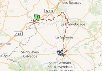
Randonnée Vélo de 39 km à découvrir à Normandie, Manche, Tessy-Bocage. Cette randonnée est proposée par mimi53.
Description
10 jours, attention ca grimpe dur et très souvent, la journée fut épuisante mais reprise de la voie verte a la Graverie jusqu'à Vire
Localisation
Pays :
France
Région :
Normandie
Département/Province :
Manche
Commune :
Tessy-Bocage
Localité :
Unknown
Départ:(Dec)
Départ:(UTM)
644064 ; 5422405 (30U) N.
Commentaires
Randonnées à proximité
![Randonnée Marche nordique Tessy-Bocage - rando haras pont farcy - Photo](https://media.geolcdn.com/t/375/260/3415af69-7f2b-496f-a8fd-837c9e113cab.jpg&format=jpg&maxdim=2)
![Marche nordique Marche nordique](https://static1.geolcdn.com/sitytour/trail-icons/102.png)
rando haras pont farcy
Marche nordique
Très facile
(1)
Tessy-Bocage,
Normandie,
Manche,
France
![](/images/other/stat-length.png)
9,9 km | 11,9 km-effort
2h 1min
![](https://static1.geolcdn.com/siteimages/upload/files/16400158638029165_repeat_loop_refresh_sync_direction_icon.png)
Non
![Randonnée Marche nordique Gouvets - rando eleanore - Photo](https://media.geolcdn.com/t/375/260/ext.jpg?maxdim=2&url=https%3A%2F%2Fstatic1.geolcdn.com%2Fsiteimages%2Fupload%2Ffiles%2F1545311037marcheuse_200dpi.jpg)
![Marche nordique Marche nordique](https://static1.geolcdn.com/sitytour/trail-icons/102.png)
rando eleanore
Marche nordique
Difficile
(1)
Gouvets,
Normandie,
Manche,
France
![](/images/other/stat-length.png)
11,1 km | 13,7 km-effort
2h 14min
![](https://static1.geolcdn.com/siteimages/upload/files/16400158638029165_repeat_loop_refresh_sync_direction_icon.png)
Oui
![Randonnée Marche Tessy-Bocage - Tessy-sur-Vire - C 13-V - Photo](https://media.geolcdn.com/t/375/260/ext.jpg?maxdim=2&url=https%3A%2F%2Fservices.sitytrail.com%2FGeolivesWS%2FDownloadMedia.ashx%3FTrailID%3D111302%26Media%3D6947_5.jpg)
![Marche Marche](https://static1.geolcdn.com/sitytour/trail-icons/101.png)
Tessy-sur-Vire - C 13-V
Marche
Facile
Tessy-Bocage,
Normandie,
Manche,
France
![](/images/other/stat-length.png)
3,4 km | 4,1 km-effort
1h 0min
![](https://static1.geolcdn.com/siteimages/upload/files/16400158638029165_repeat_loop_refresh_sync_direction_icon.png)
Oui
![Randonnée V.T.T. Tessy-Bocage - Tessy-sur-Vire - C 13-II - Photo](https://media.geolcdn.com/t/375/260/ext.jpg?maxdim=2&url=https%3A%2F%2Fservices.sitytrail.com%2FGeolivesWS%2FDownloadMedia.ashx%3FTrailID%3D111296%26Media%3D6939_4.jpg)
![V.T.T. V.T.T.](https://static1.geolcdn.com/sitytour/trail-icons/202.png)
Tessy-sur-Vire - C 13-II
V.T.T.
Facile
Tessy-Bocage,
Normandie,
Manche,
France
![](/images/other/stat-length.png)
8,8 km | 10,5 km-effort
1h 0min
![](https://static1.geolcdn.com/siteimages/upload/files/16400158638029165_repeat_loop_refresh_sync_direction_icon.png)
Oui
![Randonnée Marche Tessy-Bocage - Tessy-sur-Vire - C 13-II - Photo](https://media.geolcdn.com/t/375/260/ext.jpg?maxdim=2&url=https%3A%2F%2Fservices.sitytrail.com%2FGeolivesWS%2FDownloadMedia.ashx%3FTrailID%3D111295%26Media%3D6939_4.jpg)
![Marche Marche](https://static1.geolcdn.com/sitytour/trail-icons/101.png)
Tessy-sur-Vire - C 13-II
Marche
Moyen
Tessy-Bocage,
Normandie,
Manche,
France
![](/images/other/stat-length.png)
8,8 km | 10,5 km-effort
2h 15min
![](https://static1.geolcdn.com/siteimages/upload/files/16400158638029165_repeat_loop_refresh_sync_direction_icon.png)
Oui
![Randonnée Marche Tessy-Bocage - Tessy-sur-Vire - C 13-I - Photo](https://media.geolcdn.com/t/375/260/ext.jpg?maxdim=2&url=https%3A%2F%2Fservices.sitytrail.com%2FGeolivesWS%2FDownloadMedia.ashx%3FTrailID%3D111294%26Media%3D6938_3.jpg)
![Marche Marche](https://static1.geolcdn.com/sitytour/trail-icons/101.png)
Tessy-sur-Vire - C 13-I
Marche
Facile
Tessy-Bocage,
Normandie,
Manche,
France
![](/images/other/stat-length.png)
3,6 km | 4,7 km-effort
1h 0min
![](https://static1.geolcdn.com/siteimages/upload/files/16400158638029165_repeat_loop_refresh_sync_direction_icon.png)
Oui
![Randonnée V.T.T. Fourneaux - Circuit de Fourneaux - C11-I - Photo](https://media.geolcdn.com/t/375/260/ext.jpg?maxdim=2&url=https%3A%2F%2Fservices.sitytrail.com%2FGeolivesWS%2FDownloadMedia.ashx%3FTrailID%3D111262%26Media%3D6868_2.jpg)
![V.T.T. V.T.T.](https://static1.geolcdn.com/sitytour/trail-icons/202.png)
Circuit de Fourneaux - C11-I
V.T.T.
Facile
Fourneaux,
Normandie,
Manche,
France
![](/images/other/stat-length.png)
5,6 km | 6,9 km-effort
30min
![](https://static1.geolcdn.com/siteimages/upload/files/16400158638029165_repeat_loop_refresh_sync_direction_icon.png)
Oui
![Randonnée Marche Fourneaux - Circuit de Fourneaux - C11-I - Photo](https://media.geolcdn.com/t/375/260/ext.jpg?maxdim=2&url=https%3A%2F%2Fservices.sitytrail.com%2FGeolivesWS%2FDownloadMedia.ashx%3FTrailID%3D111261%26Media%3D6868_3.jpg)
![Marche Marche](https://static1.geolcdn.com/sitytour/trail-icons/101.png)
Circuit de Fourneaux - C11-I
Marche
Facile
Fourneaux,
Normandie,
Manche,
France
![](/images/other/stat-length.png)
5,6 km | 6,9 km-effort
1h 30min
![](https://static1.geolcdn.com/siteimages/upload/files/16400158638029165_repeat_loop_refresh_sync_direction_icon.png)
Oui
![Randonnée V.T.T. Gouvets - Circuit de Gouvets - C8 III - Photo](https://media.geolcdn.com/t/375/260/ext.jpg?maxdim=2&url=https%3A%2F%2Fservices.sitytrail.com%2FGeolivesWS%2FDownloadMedia.ashx%3FTrailID%3D111251%26Media%3D6830_5.jpg)
![V.T.T. V.T.T.](https://static1.geolcdn.com/sitytour/trail-icons/202.png)
Circuit de Gouvets - C8 III
V.T.T.
Moyen
Gouvets,
Normandie,
Manche,
France
![](/images/other/stat-length.png)
16,6 km | 22 km-effort
1h 45min
![](https://static1.geolcdn.com/siteimages/upload/files/16400158638029165_repeat_loop_refresh_sync_direction_icon.png)
Oui