![](/images/other/stat-length.png)
![Randonnée Marche Chanteix - Chanteix- Du puy Maurians aux Zignalets - Photo](https://media.geolcdn.com/t/1900/400/ext.pjpeg?maxdim=2&url=https%3A%2F%2Fstatic1.geolcdn.com%2Fsiteimages%2Fupload%2Ffiles%2F1553511878bg_sport_marche.png)
Chanteix- Du puy Maurians aux Zignalets
houbart
Utilisateur
![Longueur](/images/other/stat-length.png)
Longueur
7,6 km
![Altitude max](https://static1.geolcdn.com/siteimages/upload/files/1508320355ic_sort_altitude_max_24dp.png)
Altitude max
402 m
![Dénivelé positif](https://static1.geolcdn.com/siteimages/upload/files/1508320355ic_sort_den_pos_24dp.png)
Dénivelé positif
171 m
![Km-Effort](/images/other/stat-length.png)
Km-Effort
9,8 km
![Altitude min](https://static1.geolcdn.com/siteimages/upload/files/1508320355ic_sort_altitude_min_24dp.png)
Altitude min
345 m
![Dénivelé négatif](https://static1.geolcdn.com/siteimages/upload/files/1508320355ic_sort_den_neg_24dp.png)
Dénivelé négatif
170 m
![Boucle](https://static1.geolcdn.com/siteimages/upload/files/16400158638029165_repeat_loop_refresh_sync_direction_icon.png)
Boucle
Oui
Date de création :
2019-03-28 15:47:18.289
Dernière modification :
2019-03-28 15:47:18.33
![Marche](https://static1.geolcdn.com/sitytour/trail-icons/101.png)
2h14
Difficulté : Facile
![Scannez ce code QR pour ouvrir la randonnée dans l'application SityTrail](https://capi.geolives.com/qq0zvz2zws4bq2lad0pu/sitytour/trails/610874/qr.png?size=200)
Application GPS de randonnée GRATUITE
À propos
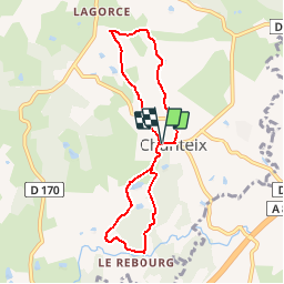
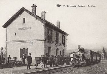
Randonnée Marche de 7,6 km à découvrir à Nouvelle-Aquitaine, Corrèze, Chanteix. Cette randonnée est proposée par houbart.
Description
Départ entre l’église du XIIème siècle et l’orme de la Liberté. Superbe vue sur la vallée du Maumont à l’entrée du village du Rebourg.
Localisation
Pays :
France
Région :
Nouvelle-Aquitaine
Département/Province :
Corrèze
Commune :
Chanteix
Localité :
Unknown
Départ:(Dec)
Départ:(UTM)
393042 ; 5018286 (31T) N.
Commentaires
Randonnées à proximité
![Randonnée Marche Saint-Germain-les-Vergnes - Tour de l'Etang de Lachamp - Photo](https://media.geolcdn.com/t/375/260/ext.jpg?maxdim=2&url=https%3A%2F%2Fservices.sitytrail.com%2FGeolivesWS%2FDownloadMedia.ashx%3FTrailID%3D143664%26Media%3D20120804184154.jpg)
![Marche Marche](https://static1.geolcdn.com/sitytour/trail-icons/101.png)
Tour de l'Etang de Lachamp
Marche
Très facile
(1)
Saint-Germain-les-Vergnes,
Nouvelle-Aquitaine,
Corrèze,
France
![](/images/other/stat-length.png)
3,5 km | 4,1 km-effort
1h 26min
![](https://static1.geolcdn.com/siteimages/upload/files/16400158638029165_repeat_loop_refresh_sync_direction_icon.png)
Oui
![Randonnée Marche Lagraulière - Lagraulière - Le Picoulet - Photo](https://media.geolcdn.com/t/375/260/ext.jpg?maxdim=2&url=https%3A%2F%2Fstatic1.geolcdn.com%2Fsiteimages%2Fupload%2Ffiles%2F1553511878bg_sport_marche.png)
![Marche Marche](https://static1.geolcdn.com/sitytour/trail-icons/101.png)
Lagraulière - Le Picoulet
Marche
Facile
(1)
Lagraulière,
Nouvelle-Aquitaine,
Corrèze,
France
![](/images/other/stat-length.png)
4,8 km | 5,8 km-effort
1h 10min
![](https://static1.geolcdn.com/siteimages/upload/files/16400158638029165_repeat_loop_refresh_sync_direction_icon.png)
Oui
![Randonnée Marche Lagraulière - Lagauliere - Photo](https://media.geolcdn.com/t/375/260/ab6f5ec5-1d9a-4213-92fa-1679c80f35be.jpg&format=jpg&maxdim=2)
![Marche Marche](https://static1.geolcdn.com/sitytour/trail-icons/101.png)
Lagauliere
Marche
Très facile
Lagraulière,
Nouvelle-Aquitaine,
Corrèze,
France
![](/images/other/stat-length.png)
4,8 km | 5,8 km-effort
1h 10min
![](https://static1.geolcdn.com/siteimages/upload/files/16400158638029165_repeat_loop_refresh_sync_direction_icon.png)
Oui
![Randonnée Marche Lagraulière - Lagraulière- Forêt de Blanchefort - Photo](https://media.geolcdn.com/t/375/260/ext.jpg?maxdim=2&url=https%3A%2F%2Fstatic1.geolcdn.com%2Fsiteimages%2Fupload%2Ffiles%2F1553511878bg_sport_marche.png)
![Marche Marche](https://static1.geolcdn.com/sitytour/trail-icons/101.png)
Lagraulière- Forêt de Blanchefort
Marche
Très facile
(1)
Lagraulière,
Nouvelle-Aquitaine,
Corrèze,
France
![](/images/other/stat-length.png)
8,9 km | 11,6 km-effort
2h 28min
![](https://static1.geolcdn.com/siteimages/upload/files/16400158638029165_repeat_loop_refresh_sync_direction_icon.png)
Oui
![Randonnée Marche Favars - Autour de Favars - Photo](https://media.geolcdn.com/t/375/260/ext.jpg?maxdim=2&url=https%3A%2F%2Fservices.sitytrail.com%2FGeolivesWS%2FDownloadMedia.ashx%3FTrailID%3D857239%26Media%3Dfix__20171104145027.jpg)
![Marche Marche](https://static1.geolcdn.com/sitytour/trail-icons/101.png)
Autour de Favars
Marche
Facile
Favars,
Nouvelle-Aquitaine,
Corrèze,
France
![](/images/other/stat-length.png)
16,1 km | 21 km-effort
4h 55min
![](https://static1.geolcdn.com/siteimages/upload/files/16400158638029165_repeat_loop_refresh_sync_direction_icon.png)
Oui
![Randonnée Marche Saint-Clément - Sur les Rails de Bussières - Saint Clément - Pays de Tulle - Photo](https://media.geolcdn.com/t/375/260/ext.jpg?maxdim=2&url=https%3A%2F%2Fservices.sitytrail.com%2FGeolivesWS%2FDownloadMedia.ashx%3FTrailID%3D318023%26Media%3D17485_2.jpg)
![Marche Marche](https://static1.geolcdn.com/sitytour/trail-icons/101.png)
Sur les Rails de Bussières - Saint Clément - Pays de Tulle
Marche
Moyen
Saint-Clément,
Nouvelle-Aquitaine,
Corrèze,
France
![](/images/other/stat-length.png)
9,9 km | 12,4 km-effort
2h 15min
![](https://static1.geolcdn.com/siteimages/upload/files/16400158638029165_repeat_loop_refresh_sync_direction_icon.png)
Oui
![Randonnée Marche Lagraulière - Le Moulin de Mazel - Lagraulière - Pays de Tulle - Photo](https://media.geolcdn.com/t/375/260/ext.jpg?maxdim=2&url=https%3A%2F%2Fservices.sitytrail.com%2FGeolivesWS%2FDownloadMedia.ashx%3FTrailID%3D318004%26Media%3D17459_2.jpg)
![Marche Marche](https://static1.geolcdn.com/sitytour/trail-icons/101.png)
Le Moulin de Mazel - Lagraulière - Pays de Tulle
Marche
Moyen
(2)
Lagraulière,
Nouvelle-Aquitaine,
Corrèze,
France
![](/images/other/stat-length.png)
9,1 km | 11,6 km-effort
2h 30min
![](https://static1.geolcdn.com/siteimages/upload/files/16400158638029165_repeat_loop_refresh_sync_direction_icon.png)
Oui
![Randonnée Marche Lagraulière - Lagrauliere- Les amoureux de la forêt de Blanchefort - Photo](https://media.geolcdn.com/t/375/260/ext.jpg?maxdim=2&url=https%3A%2F%2Fstatic1.geolcdn.com%2Fsiteimages%2Fupload%2Ffiles%2F1553511878bg_sport_marche.png)
![Marche Marche](https://static1.geolcdn.com/sitytour/trail-icons/101.png)
Lagrauliere- Les amoureux de la forêt de Blanchefort
Marche
Moyen
Lagraulière,
Nouvelle-Aquitaine,
Corrèze,
France
![](/images/other/stat-length.png)
9,8 km | 12,2 km-effort
2h 37min
![](https://static1.geolcdn.com/siteimages/upload/files/16400158638029165_repeat_loop_refresh_sync_direction_icon.png)
Oui
![Randonnée Marche Lagraulière - lagrauliere - Photo](https://media.geolcdn.com/t/375/260/ext.jpg?maxdim=2&url=https%3A%2F%2Fstatic1.geolcdn.com%2Fsiteimages%2Fupload%2Ffiles%2F1553511878bg_sport_marche.png)
![Marche Marche](https://static1.geolcdn.com/sitytour/trail-icons/101.png)
lagrauliere
Marche
Très facile
Lagraulière,
Nouvelle-Aquitaine,
Corrèze,
France
![](/images/other/stat-length.png)
13,8 km | 17,1 km-effort
3h 21min
![](https://static1.geolcdn.com/siteimages/upload/files/16400158638029165_repeat_loop_refresh_sync_direction_icon.png)
Non