![](/images/other/stat-length.png)
![Randonnée Marche Salignac-Eyvigues - Orliaguet - Photo](https://media.geolcdn.com/t/1900/400/ext.pjpeg?maxdim=2&url=https%3A%2F%2Fstatic1.geolcdn.com%2Fsiteimages%2Fupload%2Ffiles%2F1553511878bg_sport_marche.png)
Orliaguet
Pierre11
Utilisateur
![Longueur](/images/other/stat-length.png)
Longueur
15,2 km
![Altitude max](https://static1.geolcdn.com/siteimages/upload/files/1508320355ic_sort_altitude_max_24dp.png)
Altitude max
297 m
![Dénivelé positif](https://static1.geolcdn.com/siteimages/upload/files/1508320355ic_sort_den_pos_24dp.png)
Dénivelé positif
318 m
![Km-Effort](/images/other/stat-length.png)
Km-Effort
19,4 km
![Altitude min](https://static1.geolcdn.com/siteimages/upload/files/1508320355ic_sort_altitude_min_24dp.png)
Altitude min
128 m
![Dénivelé négatif](https://static1.geolcdn.com/siteimages/upload/files/1508320355ic_sort_den_neg_24dp.png)
Dénivelé négatif
314 m
![Boucle](https://static1.geolcdn.com/siteimages/upload/files/16400158638029165_repeat_loop_refresh_sync_direction_icon.png)
Boucle
Oui
Date de création :
2016-07-31 00:00:00.0
Dernière modification :
2016-07-31 00:00:00.0
![Marche](https://static1.geolcdn.com/sitytour/trail-icons/101.png)
4h22
Difficulté : Moyen
![Scannez ce code QR pour ouvrir la randonnée dans l'application SityTrail](https://capi.geolives.com/qq0zvz2zws4bq2lad0pu/sitytour/trails/606563/qr.png?size=200)
Application GPS de randonnée GRATUITE
À propos
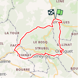
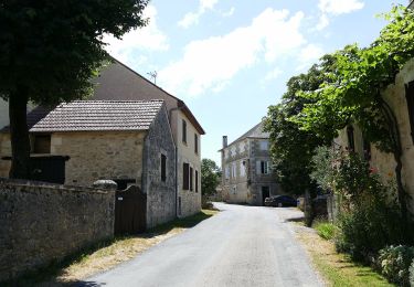
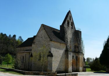
Randonnée Marche de 15,2 km à découvrir à Nouvelle-Aquitaine, Dordogne, Salignac-Eyvigues. Cette randonnée est proposée par Pierre11.
Description
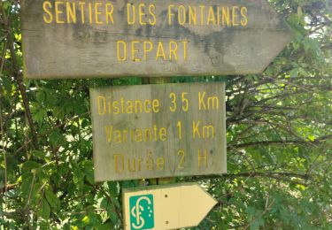
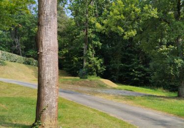
Depuis le Bois du Lac (Eyvigues) randonnée vers les Combes d'Orliaguet en empruntant le chemin des Fontaines, agrémenté de nombreux panneaux explicatifs
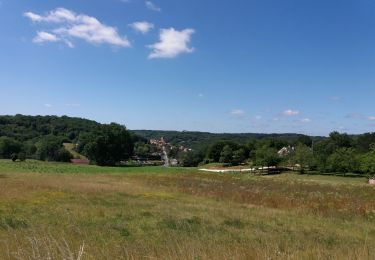
Retour par le vallon du Mianson
Localisation
Pays :
France
Région :
Nouvelle-Aquitaine
Département/Province :
Dordogne
Commune :
Salignac-Eyvigues
Localité :
Unknown
Départ:(Dec)
Départ:(UTM)
370267 ; 4977352 (31T) N.
Commentaires
Randonnées à proximité
![Randonnée A pied Salignac-Eyvigues - Sentier des Fontaines - Photo](https://media.geolcdn.com/t/375/260/ext.jpg?maxdim=2&url=https%3A%2F%2Fmedia.geolcdn.com%2Ff%2Fa10682cf-bd62-402c-91c4-a1de293eda80.jpeg)
![A pied A pied](https://static1.geolcdn.com/sitytour/trail-icons/100.png)
Sentier des Fontaines
A pied
Facile
Salignac-Eyvigues,
Nouvelle-Aquitaine,
Dordogne,
France
![](/images/other/stat-length.png)
3,3 km | 4,8 km-effort
1h 4min
![](https://static1.geolcdn.com/siteimages/upload/files/16400158638029165_repeat_loop_refresh_sync_direction_icon.png)
Oui
![Randonnée Marche Salignac-Eyvigues - Sentier des Fontaines - Photo](https://media.geolcdn.com/t/375/260/ext.jpg?maxdim=2&url=https%3A%2F%2Fmedia.geolcdn.com%2Ff%2F309dcb3c-e1ce-41b6-adfe-f203c4632474.jpg)
![Marche Marche](https://static1.geolcdn.com/sitytour/trail-icons/101.png)
Sentier des Fontaines
Marche
Facile
Salignac-Eyvigues,
Nouvelle-Aquitaine,
Dordogne,
France
![](/images/other/stat-length.png)
3,6 km | 5,2 km-effort
1h 33min
![](https://static1.geolcdn.com/siteimages/upload/files/16400158638029165_repeat_loop_refresh_sync_direction_icon.png)
Oui
![Randonnée Marche Salignac-Eyvigues - Camping](https://media.geolcdn.com/t/375/260/ext.jpg?maxdim=2&url=https%3A%2F%2Fmedia.geolcdn.com%2Ff%2F0e4846dd-4e9f-4599-8601-88ceeba50f1e.jpg)
![Marche Marche](https://static1.geolcdn.com/sitytour/trail-icons/101.png)
Camping "le temps de vivre"
Marche
Facile
Salignac-Eyvigues,
Nouvelle-Aquitaine,
Dordogne,
France
![](/images/other/stat-length.png)
3,2 km | 4,6 km-effort
1h 0min
![](https://static1.geolcdn.com/siteimages/upload/files/16400158638029165_repeat_loop_refresh_sync_direction_icon.png)
Oui
![Randonnée Marche Salignac-Eyvigues - Petite boucle du temps de vivre - Photo](https://media.geolcdn.com/t/375/260/ext.jpg?maxdim=2&url=https%3A%2F%2Fmedia.geolcdn.com%2Ff%2Fa49c80a8-634f-4524-ac24-88f5e3d2cb67.jpg)
![Marche Marche](https://static1.geolcdn.com/sitytour/trail-icons/101.png)
Petite boucle du temps de vivre
Marche
Facile
Salignac-Eyvigues,
Nouvelle-Aquitaine,
Dordogne,
France
![](/images/other/stat-length.png)
3,1 km | 4,5 km-effort
55min
![](https://static1.geolcdn.com/siteimages/upload/files/16400158638029165_repeat_loop_refresh_sync_direction_icon.png)
Oui
![Randonnée A pied Sainte-Nathalène - Sentier du Manoir d'Eyrignac - Photo](https://media.geolcdn.com/t/375/260/ext.jpg?maxdim=2&url=https%3A%2F%2Fmedia.geolcdn.com%2Ff%2F5f5a7972-42b3-4517-b8d7-b481567f4d2d.jpeg)
![A pied A pied](https://static1.geolcdn.com/sitytour/trail-icons/100.png)
Sentier du Manoir d'Eyrignac
A pied
Facile
Sainte-Nathalène,
Nouvelle-Aquitaine,
Dordogne,
France
![](/images/other/stat-length.png)
5,1 km | 6,5 km-effort
1h 29min
![](https://static1.geolcdn.com/siteimages/upload/files/16400158638029165_repeat_loop_refresh_sync_direction_icon.png)
Non
![Randonnée Marche Simeyrols - boucle simeyrol - Photo](https://media.geolcdn.com/t/375/260/ext.jpg?maxdim=2&url=https%3A%2F%2Fmedia.geolcdn.com%2Ff%2F9ce7c0b3-974f-43b9-baf2-7f4ef3567230.jpg)
![Marche Marche](https://static1.geolcdn.com/sitytour/trail-icons/101.png)
boucle simeyrol
Marche
Facile
Simeyrols,
Nouvelle-Aquitaine,
Dordogne,
France
![](/images/other/stat-length.png)
13,1 km | 17,1 km-effort
3h 1min
![](https://static1.geolcdn.com/siteimages/upload/files/16400158638029165_repeat_loop_refresh_sync_direction_icon.png)
Oui
![Randonnée Autre activité Peyrillac-et-Millac - Atlamed - millac - lacave - Photo](https://media.geolcdn.com/t/375/260/ext.jpg?maxdim=2&url=https%3A%2F%2Fservices.sitytrail.com%2FGeolivesWS%2FDownloadMedia.ashx%3FTrailID%3D695701%26Media%3D20170205155933.jpg)
![Autre activité Autre activité](https://static1.geolcdn.com/sitytour/trail-icons/900.png)
Atlamed - millac - lacave
Autre activité
Très facile
Peyrillac-et-Millac,
Nouvelle-Aquitaine,
Dordogne,
France
![](/images/other/stat-length.png)
19,6 km | 25 km-effort
4h 8min
![](https://static1.geolcdn.com/siteimages/upload/files/16400158638029165_repeat_loop_refresh_sync_direction_icon.png)
Non
![Randonnée Marche Salignac-Eyvigues - Boucle d'Eyrignac - Photo](https://media.geolcdn.com/t/375/260/ext.jpg?maxdim=2&url=https%3A%2F%2Fstatic1.geolcdn.com%2Fsiteimages%2Fupload%2Ffiles%2F1553511878bg_sport_marche.png)
![Marche Marche](https://static1.geolcdn.com/sitytour/trail-icons/101.png)
Boucle d'Eyrignac
Marche
Difficile
(3)
Salignac-Eyvigues,
Nouvelle-Aquitaine,
Dordogne,
France
![](/images/other/stat-length.png)
14,3 km | 18,4 km-effort
4h 11min
![](https://static1.geolcdn.com/siteimages/upload/files/16400158638029165_repeat_loop_refresh_sync_direction_icon.png)
Oui
![Randonnée Marche Simeyrols - SIMEYROLS - Photo](https://media.geolcdn.com/t/375/260/ext.jpg?maxdim=2&url=https%3A%2F%2Fstatic1.geolcdn.com%2Fsiteimages%2Fupload%2Ffiles%2F1553511878bg_sport_marche.png)
![Marche Marche](https://static1.geolcdn.com/sitytour/trail-icons/101.png)
SIMEYROLS
Marche
Moyen
Simeyrols,
Nouvelle-Aquitaine,
Dordogne,
France
![](/images/other/stat-length.png)
12,6 km | 16,6 km-effort
3h 7min
![](https://static1.geolcdn.com/siteimages/upload/files/16400158638029165_repeat_loop_refresh_sync_direction_icon.png)
Oui