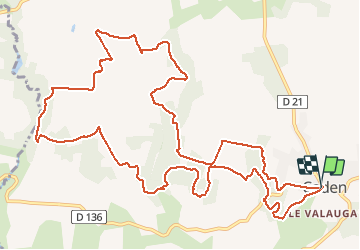
![](/images/other/stat-length.png)
![Randonnée Marche Caden - Le grand val, caden - Photo](https://media.geolcdn.com/t/1900/400/ext.pjpeg?maxdim=2&url=https%3A%2F%2Fservices.sitytrail.com%2FGeolivesWS%2FDownloadMedia.ashx%3FTrailID%3D601953%26Media%3D0abf02b0-773e-415a-8a15-6135a09fd368.jpg)
Le grand val, caden
lfallek
Utilisateur
![Longueur](/images/other/stat-length.png)
![Altitude max](https://static1.geolcdn.com/siteimages/upload/files/1508320355ic_sort_altitude_max_24dp.png)
![Dénivelé positif](https://static1.geolcdn.com/siteimages/upload/files/1508320355ic_sort_den_pos_24dp.png)
![Km-Effort](/images/other/stat-length.png)
![Altitude min](https://static1.geolcdn.com/siteimages/upload/files/1508320355ic_sort_altitude_min_24dp.png)
![Dénivelé négatif](https://static1.geolcdn.com/siteimages/upload/files/1508320355ic_sort_den_neg_24dp.png)
![Boucle](https://static1.geolcdn.com/siteimages/upload/files/16400158638029165_repeat_loop_refresh_sync_direction_icon.png)
![Marche](https://static1.geolcdn.com/sitytour/trail-icons/101.png)
2h00
Difficulté : Moyen
![Scannez ce code QR pour ouvrir la randonnée dans l'application SityTrail](https://capi.geolives.com/qq0zvz2zws4bq2lad0pu/sitytour/trails/601953/qr.png?size=200)
Application GPS de randonnée GRATUITE
À propos
Randonnée Marche de 15 km à découvrir à Bretagne, Morbihan, Caden. Cette randonnée est proposée par lfallek.
Description
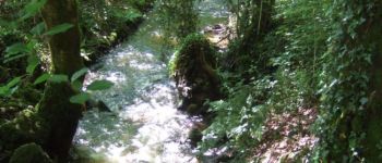
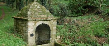
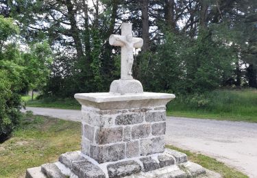
Cette longue boucle traverse de grands espaces boisés de chênes et de châtaigniers, notamment le Grand Val, au fond duquel coule le ruisseau du Matz. Elle conduit jusqu’à la vallée du ruisseau du Trévelo qui sépare les communes de Caden et Limerzel.
Balisage VTT et jaune- circuit PR sens inverse
Plus d’info : www.rochefortenterre-tourisme.com
Retrouvez tous les circuits de randonnée sur le site www.rando-paysdevannes.com
Localisation
Commentaires
Randonnées à proximité
![Randonnée Marche Limerzel - PR_56_Limerzel_AA_01_Circuit1b_Vallee-Du-Trevelo_20231215 - Photo](https://media.geolcdn.com/t/375/260/b434d388-f2cf-4273-a9c9-f910c9f7a88a.jpg&format=jpg&maxdim=2)
![Marche Marche](https://static1.geolcdn.com/sitytour/trail-icons/101.png)
Marche
![](/images/other/stat-length.png)
![](https://static1.geolcdn.com/siteimages/upload/files/16400158638029165_repeat_loop_refresh_sync_direction_icon.png)
![Randonnée Marche Péaule - PR_56_Peaule_BA_02_Circuit3b_De-L-Etier_20230914 - Photo](https://media.geolcdn.com/t/375/260/f17b2106-29c9-443c-b455-5d085c7b6379.jpg&format=jpg&maxdim=2)
![Marche Marche](https://static1.geolcdn.com/sitytour/trail-icons/101.png)
Marche
![](/images/other/stat-length.png)
![](https://static1.geolcdn.com/siteimages/upload/files/16400158638029165_repeat_loop_refresh_sync_direction_icon.png)
![Randonnée Marche Limerzel - GRP_Lanvaux_AI_09_Limerzel_Berric_20210528 - Photo](https://media.geolcdn.com/t/375/260/c931dd36-7661-451d-be62-fb02e50c34f3.jpg&format=jpg&maxdim=2)
![Marche Marche](https://static1.geolcdn.com/sitytour/trail-icons/101.png)
Marche
![](/images/other/stat-length.png)
![](https://static1.geolcdn.com/siteimages/upload/files/16400158638029165_repeat_loop_refresh_sync_direction_icon.png)
![Randonnée Marche Caden - PR_56_Caden_AA_01_Circuit1b_Le-Grand-Val_20200524 - Photo](https://media.geolcdn.com/t/375/260/422278ab-db23-4bf4-a06f-32394ef99a0f.jpg&format=jpg&maxdim=2)
![Marche Marche](https://static1.geolcdn.com/sitytour/trail-icons/101.png)
Marche
![](/images/other/stat-length.png)
![](https://static1.geolcdn.com/siteimages/upload/files/16400158638029165_repeat_loop_refresh_sync_direction_icon.png)
![Randonnée Marche Béganne - Circuit des 2 vallées - Béganne - Photo](https://media.geolcdn.com/t/375/260/ext.jpg?maxdim=2&url=https%3A%2F%2Fservices.sitytrail.com%2FGeolivesWS%2FDownloadMedia.ashx%3FTrailID%3D111433%26Media%3D7246_4.jpg)
![Marche Marche](https://static1.geolcdn.com/sitytour/trail-icons/101.png)
Marche
![](/images/other/stat-length.png)
![](https://static1.geolcdn.com/siteimages/upload/files/16400158638029165_repeat_loop_refresh_sync_direction_icon.png)
![Randonnée Marche Béganne - 216- circuit de la Bouloterie par Bignac. - Photo](https://media.geolcdn.com/t/375/260/d24d91d3-711f-48f3-b413-d07ef7e05936.jpg&format=jpg&maxdim=2)
![Marche Marche](https://static1.geolcdn.com/sitytour/trail-icons/101.png)
Marche
![](/images/other/stat-length.png)
![](https://static1.geolcdn.com/siteimages/upload/files/16400158638029165_repeat_loop_refresh_sync_direction_icon.png)
![Randonnée Marche Limerzel - 192- la vallée du Trévelo - Photo](https://media.geolcdn.com/t/375/260/118c7e85-b6b5-4111-bf8d-236391bf9068.jpg&format=jpg&maxdim=2)
![Marche Marche](https://static1.geolcdn.com/sitytour/trail-icons/101.png)
Marche
![](/images/other/stat-length.png)
![](https://static1.geolcdn.com/siteimages/upload/files/16400158638029165_repeat_loop_refresh_sync_direction_icon.png)
![Randonnée Marche Limerzel - 196 - rando du sillon Limerzel - Photo](https://media.geolcdn.com/t/375/260/ff8b2d16-fa07-4205-863f-1f2750659492.jpg&format=jpg&maxdim=2)
![Marche Marche](https://static1.geolcdn.com/sitytour/trail-icons/101.png)
Marche
![](/images/other/stat-length.png)
![](https://static1.geolcdn.com/siteimages/upload/files/16400158638029165_repeat_loop_refresh_sync_direction_icon.png)
![Randonnée V.T.T. Béganne - Beganne 2022 - Photo](https://media.geolcdn.com/t/375/260/ext.jpg?maxdim=2&url=https%3A%2F%2Fstatic1.geolcdn.com%2Fsiteimages%2Fupload%2Ffiles%2F1524743154velo.jpg)
![V.T.T. V.T.T.](https://static1.geolcdn.com/sitytour/trail-icons/202.png)