![](/images/other/stat-length.png)
![Randonnée Marche Linthal - Lac de la Lauch - Grand Ballon - Photo](https://media.geolcdn.com/t/1900/400/ext.pjpeg?maxdim=2&url=https%3A%2F%2Fstatic1.geolcdn.com%2Fsiteimages%2Fupload%2Ffiles%2F1553511878bg_sport_marche.png)
Lac de la Lauch - Grand Ballon
LaurentGILG
Utilisateur
![Longueur](/images/other/stat-length.png)
Longueur
21 km
![Altitude max](https://static1.geolcdn.com/siteimages/upload/files/1508320355ic_sort_altitude_max_24dp.png)
Altitude max
1420 m
![Dénivelé positif](https://static1.geolcdn.com/siteimages/upload/files/1508320355ic_sort_den_pos_24dp.png)
Dénivelé positif
883 m
![Km-Effort](/images/other/stat-length.png)
Km-Effort
32 km
![Altitude min](https://static1.geolcdn.com/siteimages/upload/files/1508320355ic_sort_altitude_min_24dp.png)
Altitude min
925 m
![Dénivelé négatif](https://static1.geolcdn.com/siteimages/upload/files/1508320355ic_sort_den_neg_24dp.png)
Dénivelé négatif
873 m
![Boucle](https://static1.geolcdn.com/siteimages/upload/files/16400158638029165_repeat_loop_refresh_sync_direction_icon.png)
Boucle
Oui
Date de création :
2019-01-20 20:50:33.877
Dernière modification :
2019-01-20 20:50:33.937
![Marche](https://static1.geolcdn.com/sitytour/trail-icons/101.png)
6h40
Difficulté : Très difficile
![Scannez ce code QR pour ouvrir la randonnée dans l'application SityTrail](https://capi.geolives.com/qq0zvz2zws4bq2lad0pu/sitytour/trails/596346/qr.png?size=200)
Application GPS de randonnée GRATUITE
À propos
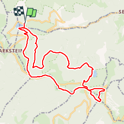
Randonnée Marche de 21 km à découvrir à Grand Est, Haut-Rhin, Linthal. Cette randonnée est proposée par LaurentGILG.
Description
Lac de La Lauch
Suivre GR532 jusqu'au Hundskopf
Puis monté au Storkenkopf
Ferme Auberge de la Haag
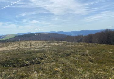
Le Grand Ballon
Ferme de le Haag
Lac du Ballon
Rollwald
Lac de la Lauch
Localisation
Pays :
France
Région :
Grand Est
Département/Province :
Haut-Rhin
Commune :
Linthal
Localité :
Unknown
Départ:(Dec)
Départ:(UTM)
354060 ; 5311062 (32T) N.
Commentaires
Randonnées à proximité
![Randonnée Marche Linthal - Markstein - Photo](https://media.geolcdn.com/t/375/260/ext.jpg?maxdim=2&url=https%3A%2F%2Fservices.sitytrail.com%2FGeolivesWS%2FDownloadMedia.ashx%3FTrailID%3D266212%26Media%3Dfix__20140413115328.jpg)
![Marche Marche](https://static1.geolcdn.com/sitytour/trail-icons/101.png)
Markstein
Marche
Moyen
(3)
Linthal,
Grand Est,
Haut-Rhin,
France
![](/images/other/stat-length.png)
14 km | 19,8 km-effort
4h 45min
![](https://static1.geolcdn.com/siteimages/upload/files/16400158638029165_repeat_loop_refresh_sync_direction_icon.png)
Oui
![Randonnée Marche Linthal - Tour de la grande Vallée de Munster (refuge du Hilsen - Munster) - Photo](https://media.geolcdn.com/t/375/260/ext.jpg?maxdim=2&url=https%3A%2F%2Fservices.sitytrail.com%2FGeolivesWS%2FDownloadMedia.ashx%3FTrailID%3D173094%26Media%3D14636_4.jpg)
![Marche Marche](https://static1.geolcdn.com/sitytour/trail-icons/101.png)
Tour de la grande Vallée de Munster (refuge du Hilsen - Munster)
Marche
Difficile
(1)
Linthal,
Grand Est,
Haut-Rhin,
France
![](/images/other/stat-length.png)
18,1 km | 24 km-effort
5h 0min
![](https://static1.geolcdn.com/siteimages/upload/files/16400158638029165_repeat_loop_refresh_sync_direction_icon.png)
Non
![Randonnée Marche Lautenbachzell - Le Markstein - Photo](https://media.geolcdn.com/t/375/260/ext.jpg?maxdim=2&url=https%3A%2F%2Fservices.sitytrail.com%2FGeolivesWS%2FDownloadMedia.ashx%3FTrailID%3D109647%26Media%3D4288_1.jpg)
![Marche Marche](https://static1.geolcdn.com/sitytour/trail-icons/101.png)
Le Markstein
Marche
Difficile
(1)
Lautenbachzell,
Grand Est,
Haut-Rhin,
France
![](/images/other/stat-length.png)
22 km | 35 km-effort
6h 0min
![](https://static1.geolcdn.com/siteimages/upload/files/16400158638029165_repeat_loop_refresh_sync_direction_icon.png)
Oui
![Randonnée Marche Linthal - 68 Remspach - Hilsen - Photo](https://media.geolcdn.com/t/375/260/ext.jpg?maxdim=2&url=https%3A%2F%2Fstatic1.geolcdn.com%2Fsiteimages%2Fupload%2Ffiles%2F1553511878bg_sport_marche.png)
![Marche Marche](https://static1.geolcdn.com/sitytour/trail-icons/101.png)
68 Remspach - Hilsen
Marche
Moyen
(1)
Linthal,
Grand Est,
Haut-Rhin,
France
![](/images/other/stat-length.png)
9,9 km | 14,6 km-effort
3h 3min
![](https://static1.geolcdn.com/siteimages/upload/files/16400158638029165_repeat_loop_refresh_sync_direction_icon.png)
Oui
![Randonnée A pied Lautenbachzell - Parking Bellevue - Hundsrucken - Markstein - Photo](https://media.geolcdn.com/t/375/260/ext.jpg?maxdim=2&url=https%3A%2F%2Fstatic1.geolcdn.com%2Fsiteimages%2Fupload%2Ffiles%2F1545311037marcheuse_200dpi.jpg)
![A pied A pied](https://static1.geolcdn.com/sitytour/trail-icons/100.png)
Parking Bellevue - Hundsrucken - Markstein
A pied
Moyen
(1)
Lautenbachzell,
Grand Est,
Haut-Rhin,
France
![](/images/other/stat-length.png)
9,4 km | 13 km-effort
Inconnu
![](https://static1.geolcdn.com/siteimages/upload/files/16400158638029165_repeat_loop_refresh_sync_direction_icon.png)
Oui
![Randonnée V.T.T. Metzeral - Breitfirst - Petit Ballon - Col de Firstplan - Wintzenheim - Photo](https://media.geolcdn.com/t/375/260/ext.jpg?maxdim=2&url=https%3A%2F%2Fstatic1.geolcdn.com%2Fsiteimages%2Fupload%2Ffiles%2F1524743154velo.jpg)
![V.T.T. V.T.T.](https://static1.geolcdn.com/sitytour/trail-icons/202.png)
Breitfirst - Petit Ballon - Col de Firstplan - Wintzenheim
V.T.T.
Moyen
(1)
Metzeral,
Grand Est,
Haut-Rhin,
France
![](/images/other/stat-length.png)
38 km | 52 km-effort
3h 11min
![](https://static1.geolcdn.com/siteimages/upload/files/16400158638029165_repeat_loop_refresh_sync_direction_icon.png)
Non
![Randonnée Marche Metzeral - 24 04 14 autour d’Uffrain - Photo](https://media.geolcdn.com/t/375/260/5d272a7d-046b-44ac-82c1-096c8c22e6f1.jpg&format=jpg&maxdim=2)
![Marche Marche](https://static1.geolcdn.com/sitytour/trail-icons/101.png)
24 04 14 autour d’Uffrain
Marche
Metzeral,
Grand Est,
Haut-Rhin,
France
![](/images/other/stat-length.png)
70 km | 83 km-effort
3h 45min
![](https://static1.geolcdn.com/siteimages/upload/files/16400158638029165_repeat_loop_refresh_sync_direction_icon.png)
Non
![Marche Marche](https://static1.geolcdn.com/sitytour/trail-icons/101.png)
Mon tour des Vosges (4 jours)
Marche
Très difficile
Soultz-Haut-Rhin,
Grand Est,
Haut-Rhin,
France
![](/images/other/stat-length.png)
71 km | 113 km-effort
25h 38min
![](https://static1.geolcdn.com/siteimages/upload/files/16400158638029165_repeat_loop_refresh_sync_direction_icon.png)
Oui
![Randonnée Marche Ranspach - Rando des Marcheurs 20/07/2023 - Photo](https://media.geolcdn.com/t/375/260/e65497d0-16d3-4e63-993c-c9f6fe260f85.jpg&format=jpg&maxdim=2)
![Marche Marche](https://static1.geolcdn.com/sitytour/trail-icons/101.png)
Rando des Marcheurs 20/07/2023
Marche
Très difficile
Ranspach,
Grand Est,
Haut-Rhin,
France
![](/images/other/stat-length.png)
23 km | 38 km-effort
5h 31min
![](https://static1.geolcdn.com/siteimages/upload/files/16400158638029165_repeat_loop_refresh_sync_direction_icon.png)
Oui