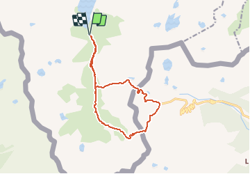
![](/images/other/stat-length.png)
![Randonnée Course à pied Auzat - TRAIL-Soulcem Arcalis (Arrivée Tour de France) - Photo](https://media.geolcdn.com/t/1900/400/ext.pjpeg?maxdim=2&url=https%3A%2F%2Fstatic1.geolcdn.com%2Fsiteimages%2Fupload%2Ffiles%2F1524743154running.jpg)
TRAIL-Soulcem Arcalis (Arrivée Tour de France)
Polo-31
Utilisateur
![Longueur](/images/other/stat-length.png)
![Altitude max](https://static1.geolcdn.com/siteimages/upload/files/1508320355ic_sort_altitude_max_24dp.png)
![Dénivelé positif](https://static1.geolcdn.com/siteimages/upload/files/1508320355ic_sort_den_pos_24dp.png)
![Km-Effort](/images/other/stat-length.png)
![Altitude min](https://static1.geolcdn.com/siteimages/upload/files/1508320355ic_sort_altitude_min_24dp.png)
![Dénivelé négatif](https://static1.geolcdn.com/siteimages/upload/files/1508320355ic_sort_den_neg_24dp.png)
![Boucle](https://static1.geolcdn.com/siteimages/upload/files/16400158638029165_repeat_loop_refresh_sync_direction_icon.png)
![Course à pied](https://static1.geolcdn.com/sitytour/trail-icons/103.png)
4h20
Difficulté : Difficile
![Scannez ce code QR pour ouvrir la randonnée dans l'application SityTrail](https://capi.geolives.com/qq0zvz2zws4bq2lad0pu/sitytour/trails/596269/qr.png?size=200)
Application GPS de randonnée GRATUITE
À propos
Randonnée Course à pied de 14,4 km à découvrir à Occitanie, Ariège, Auzat. Cette randonnée est proposée par Polo-31.
Description
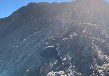
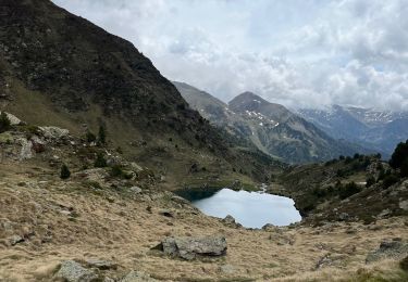
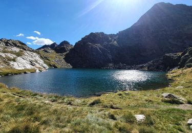
Très belle boucle. Le seul intérêt de descendre à Arcalis est d'assister à l'arrivée du Tour de France le 10/07/2016. Sinon le parcours en crête entre le Port de Rat et Le Port de Caraussans est à privilégier avec une bonne météo. Le tracé du parcours de la descente du Port de Caraussans n'est pas correct sur la carte. Bien suivre la trace ou le balisage jaune. Un peu au dessus du lac de Caraussans descendre sur la gauche du ruisseau, le chemin est bien marqué.
Localisation
Commentaires
Randonnées à proximité
![Randonnée Marche Auzat - Le Picot - Photo](https://media.geolcdn.com/t/375/260/ext.jpg?maxdim=2&url=https%3A%2F%2Fservices.sitytrail.com%2FGeolivesWS%2FDownloadMedia.ashx%3FTrailID%3D218307%26Media%3D7d32352a-7ee3-4817-a78f-8417168ce812.JPG)
![Marche Marche](https://static1.geolcdn.com/sitytour/trail-icons/101.png)
![Randonnée Marche Auzat - Les étangs de la Gardelle - Auzat - Photo](https://media.geolcdn.com/t/375/260/ext.jpg?maxdim=2&url=https%3A%2F%2Fstatic1.geolcdn.com%2Fsiteimages%2Fupload%2Ffiles%2F1553511878bg_sport_marche.png)
![Marche Marche](https://static1.geolcdn.com/sitytour/trail-icons/101.png)
Marche
![](/images/other/stat-length.png)
![](https://static1.geolcdn.com/siteimages/upload/files/16400158638029165_repeat_loop_refresh_sync_direction_icon.png)
![Marche Marche](https://static1.geolcdn.com/sitytour/trail-icons/101.png)
![Randonnée sport - Arcalis - Photo](https://media.geolcdn.com/t/375/260/04058f44-9f8f-463f-a1cc-559cb86b42ee.jpg&format=jpg&maxdim=2)
![Randonnée Marche Auzat - Domaine de Montcalm -port Rat Pic Rouge - Photo](https://media.geolcdn.com/t/375/260/4ee9492f-31eb-4d1a-b77c-878ac1f5c4df.jpg&format=jpg&maxdim=2)
![Marche Marche](https://static1.geolcdn.com/sitytour/trail-icons/101.png)
Marche
![](/images/other/stat-length.png)
![](https://static1.geolcdn.com/siteimages/upload/files/16400158638029165_repeat_loop_refresh_sync_direction_icon.png)
![Randonnée Marche Auzat - Tour des lacs - Sarroucanes - Photo](https://media.geolcdn.com/t/375/260/45e48d9e-2f03-4378-bfe0-01a4ae1719c1.jpg&format=jpg&maxdim=2)
![Marche Marche](https://static1.geolcdn.com/sitytour/trail-icons/101.png)
Marche
![](/images/other/stat-length.png)
![](https://static1.geolcdn.com/siteimages/upload/files/16400158638029165_repeat_loop_refresh_sync_direction_icon.png)
![Randonnée Marche Auzat - Caraussans - Photo](https://media.geolcdn.com/t/375/260/13f3c7b9-396a-4438-ab57-e6debb7e127e.jpg&format=jpg&maxdim=2)
![Marche Marche](https://static1.geolcdn.com/sitytour/trail-icons/101.png)
Marche
![](/images/other/stat-length.png)
![](https://static1.geolcdn.com/siteimages/upload/files/16400158638029165_repeat_loop_refresh_sync_direction_icon.png)
![Randonnée Marche Auzat - Boucle etangs de la Gardelle - Photo](https://media.geolcdn.com/t/375/260/fb25dd7f-b9c3-45ab-85f7-b885de72aafa.jpg&format=jpg&maxdim=2)
![Marche Marche](https://static1.geolcdn.com/sitytour/trail-icons/101.png)
Marche
![](/images/other/stat-length.png)
![](https://static1.geolcdn.com/siteimages/upload/files/16400158638029165_repeat_loop_refresh_sync_direction_icon.png)
![Randonnée Marche Auzat - Fourcat - Photo](https://media.geolcdn.com/t/375/260/1246df19-c72a-49ce-9f67-6435cfda3815.jpg&format=jpg&maxdim=2)
![Marche Marche](https://static1.geolcdn.com/sitytour/trail-icons/101.png)