![](/images/other/stat-length.png)
![Randonnée Marche Polignac - Polignac - Bilhac _ 9,0 km - Photo](https://media.geolcdn.com/t/1900/400/ext.pjpeg?maxdim=2&url=https%3A%2F%2Fstatic1.geolcdn.com%2Fsiteimages%2Fupload%2Ffiles%2F1553511878bg_sport_marche.png)
Polignac - Bilhac _ 9,0 km
Pousscailleux
Utilisateur
![Longueur](/images/other/stat-length.png)
![Altitude max](https://static1.geolcdn.com/siteimages/upload/files/1508320355ic_sort_altitude_max_24dp.png)
![Dénivelé positif](https://static1.geolcdn.com/siteimages/upload/files/1508320355ic_sort_den_pos_24dp.png)
![Km-Effort](/images/other/stat-length.png)
![Altitude min](https://static1.geolcdn.com/siteimages/upload/files/1508320355ic_sort_altitude_min_24dp.png)
![Dénivelé négatif](https://static1.geolcdn.com/siteimages/upload/files/1508320355ic_sort_den_neg_24dp.png)
![Boucle](https://static1.geolcdn.com/siteimages/upload/files/16400158638029165_repeat_loop_refresh_sync_direction_icon.png)
![Marche](https://static1.geolcdn.com/sitytour/trail-icons/101.png)
2h50
Difficulté : Moyen
![Scannez ce code QR pour ouvrir la randonnée dans l'application SityTrail](https://capi.geolives.com/qq0zvz2zws4bq2lad0pu/sitytour/trails/591109/qr.png?size=200)
Application GPS de randonnée GRATUITE
À propos
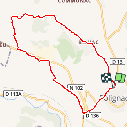
Randonnée Marche de 9 km à découvrir à Auvergne-Rhône-Alpes, Haute-Loire, Polignac. Cette randonnée est proposée par Pousscailleux.
Description
D'après le circuit N° 55 - Roche de Flayac, balisage vert - proposé par la mairie de Polignac sur son site Internet.
Parking de la maison communale, à l'entrée sud ouest de la commune, rue des écoles ; parking possible Place Princesse de Polignac, ou Place de l'église.
Départ entre la mairie et l’église, puis longer le mur d’enceinte du cimetière, ensuite tourner à gauche. Après une courte portion plate, le sentier s’élève en direction de Bilhac.
A Bilhac, passer entre la croix du centre du village et l’assemblée, poursuivre tout droit, monter vers le haut du village et prendre le chemin de terre à la dernière maison, jusqu’à la route nationale 102.
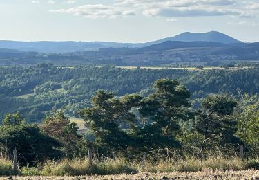
Traverser la nationale, puis suivre sur la droite un chemin de terre, possibilité de prendre le circuit n°376 sur les Estreys, vaste panorama sur la chaîne du Mézenc.
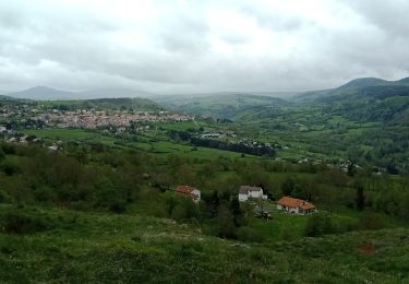
Après avoir à nouveau rejoint la RN 102, la traverser au « Collet », et descendre par un petit sentier, puis la route départementale jusqu’à Polignac.
Localisation
Commentaires
Randonnées à proximité
![Randonnée Marche Le Puy-en-Velay - Compostelle : 1-Le Puy en Vely - St Didier d'Allier - Photo](https://media.geolcdn.com/t/375/260/ext.jpg?maxdim=2&url=https%3A%2F%2Fservices.sitytrail.com%2FGeolivesWS%2FDownloadMedia.ashx%3FTrailID%3D211858%26Media%3Dfix__20130728164656.jpg)
![Marche Marche](https://static1.geolcdn.com/sitytour/trail-icons/101.png)
Marche
![](/images/other/stat-length.png)
![](https://static1.geolcdn.com/siteimages/upload/files/16400158638029165_repeat_loop_refresh_sync_direction_icon.png)
![Randonnée Marche Le Puy-en-Velay - Puy en velay - St Privat d'Allier - Chemin de Compostelle - Photo](https://media.geolcdn.com/t/375/260/ext.jpg?maxdim=2&url=https%3A%2F%2Fservices.sitytrail.com%2FGeolivesWS%2FDownloadMedia.ashx%3FTrailID%3D108145%26Media%3D198_6.jpg)
![Marche Marche](https://static1.geolcdn.com/sitytour/trail-icons/101.png)
Marche
![](/images/other/stat-length.png)
![](https://static1.geolcdn.com/siteimages/upload/files/16400158638029165_repeat_loop_refresh_sync_direction_icon.png)
![Randonnée Marche Le Puy-en-Velay - Le Puy Saugue Avril 2018 - Photo](https://media.geolcdn.com/t/375/260/ext.jpg?maxdim=2&url=https%3A%2F%2Fservices.sitytrail.com%2FGeolivesWS%2FDownloadMedia.ashx%3FTrailID%3D954919%26Media%3D2e3e85fe-c058-45c1-9a8a-a4a30709daad.JPG)
![Marche Marche](https://static1.geolcdn.com/sitytour/trail-icons/101.png)
Marche
![](/images/other/stat-length.png)
![](https://static1.geolcdn.com/siteimages/upload/files/16400158638029165_repeat_loop_refresh_sync_direction_icon.png)
![Randonnée Marche Polignac - Polignac-La Source_9,7 km - Photo](https://media.geolcdn.com/t/375/260/ext.jpg?maxdim=2&url=https%3A%2F%2Fstatic1.geolcdn.com%2Fsiteimages%2Fupload%2Ffiles%2F1553511878bg_sport_marche.png)
![Marche Marche](https://static1.geolcdn.com/sitytour/trail-icons/101.png)
Marche
![](/images/other/stat-length.png)
![](https://static1.geolcdn.com/siteimages/upload/files/16400158638029165_repeat_loop_refresh_sync_direction_icon.png)
![Randonnée Marche Le Puy-en-Velay - Compostelle 5 GR65 - Photo](https://media.geolcdn.com/t/375/260/ext.jpg?maxdim=2&url=https%3A%2F%2Fstatic1.geolcdn.com%2Fsiteimages%2Fupload%2Ffiles%2F1553511878bg_sport_marche.png)
![Marche Marche](https://static1.geolcdn.com/sitytour/trail-icons/101.png)
Marche
![](/images/other/stat-length.png)
![](https://static1.geolcdn.com/siteimages/upload/files/16400158638029165_repeat_loop_refresh_sync_direction_icon.png)
![Randonnée Marche Blanzac - Rachat - Chapelle de Chassaleuil - Photo](https://media.geolcdn.com/t/375/260/17359bb4-8e34-47fe-86ba-665518a50fe5.jpg&format=jpg&maxdim=2)
![Marche Marche](https://static1.geolcdn.com/sitytour/trail-icons/101.png)
Marche
![](/images/other/stat-length.png)
![](https://static1.geolcdn.com/siteimages/upload/files/16400158638029165_repeat_loop_refresh_sync_direction_icon.png)
![Randonnée Vélo électrique Le Puy-en-Velay - 130824 **** - Photo](https://media.geolcdn.com/t/375/260/fdfbbe51-5566-4838-83f0-e36bbf1f6406.jpg&format=jpg&maxdim=2)
![Vélo électrique Vélo électrique](https://static1.geolcdn.com/sitytour/trail-icons/205.png)
Vélo électrique
![](/images/other/stat-length.png)
![](https://static1.geolcdn.com/siteimages/upload/files/16400158638029165_repeat_loop_refresh_sync_direction_icon.png)
![Randonnée Marche Le Puy-en-Velay - 1 Stevenson Le Puy en Velay - Le Monastier sur Gazeille - Photo](https://media.geolcdn.com/t/375/260/c209631a-08c0-4975-b143-c32a8ede5982.jpg&format=jpg&maxdim=2)
![Marche Marche](https://static1.geolcdn.com/sitytour/trail-icons/101.png)
Marche
![](/images/other/stat-length.png)
![](https://static1.geolcdn.com/siteimages/upload/files/16400158638029165_repeat_loop_refresh_sync_direction_icon.png)
![Randonnée Marche Polignac - Polignac - Photo](https://media.geolcdn.com/t/375/260/ext.jpg?maxdim=2&url=https%3A%2F%2Fstatic1.geolcdn.com%2Fsiteimages%2Fupload%2Ffiles%2F1553511878bg_sport_marche.png)
![Marche Marche](https://static1.geolcdn.com/sitytour/trail-icons/101.png)
Marche
![](/images/other/stat-length.png)
![](https://static1.geolcdn.com/siteimages/upload/files/16400158638029165_repeat_loop_refresh_sync_direction_icon.png)