Randonnée V.T.T. Anhée - B.AnnheeLandrecies37B107.857.VTT0 - Photo

B.AnnheeLandrecies37B107.857.VTT0

 francois58
francois58

Utilisateur

© OpenStreetMap contributors
Longueur
Longueur
107 km
Altitude max
Altitude max
277 m
Dénivelé positif
Dénivelé positif
1280 m
Km-Effort
Km-Effort  
123 km
Altitude min
Altitude min
86 m
Dénivelé négatif
Dénivelé négatif
1216 m
Boucle
Boucle
Non
Date de création :
2016-07-22 00:00:00.0
Dernière modification :
2016-07-22 00:00:00.0

(0 Avis)

V.T.T.
V.T.T.
8h00
Difficulté : Facile

Scannez ce code QR pour ouvrir la randonnée dans l'application SityTrail

Application GPS de randonnée GRATUITE

Logo SityTrail SityTrail

IGN / Instituts géographiques

Télécharger SityTrail sur l'App Store Télécharger SityTrail sur Google Play

Logo SityTrail SityTrail World

Le monde est à vous

Télécharger SityTrail sur l'App Store Télécharger SityTrail sur Google Play Télécharger SityTrail sur Huawei AppGallery

À propos

Randonnée V.T.T. de 107 km à découvrir à Wallonie, Namur, Anhée. Cette randonnée est proposée par francois58.

Description

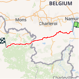
Jour 2/9 d'une randonnée Verviers - Bretagne. Aussi souvent que possible sur petites routes et chemins. Certains passages seront plus confortables en VTT.
Pneus lisses possibles si le temps est sec.

Profil altimétrique

Points d'intérêt

Point d'intérêt Florennes - CP 2 - Escorte - Photo
francois58
FLORENNES 
Point d'intérêt Mettet - CP 1 Escorte - Photo
francois58
METTET 
Point d'intérêt Mettet - Pause AM - Photo
francois58
METTET 
Point d'intérêt Walcourt - CP 3 Escorte - Photo
francois58
WALCOURT 
Point d'intérêt Walcourt - CP 4 Escorte - Photo
francois58
WALCOURT 
Point d'intérêt Beaumont - Pause Midi - Photo
francois58
BEAUMONT 
Point d'intérêt Sivry-Rance - CP 5 Escorte - Photo
francois58
SIVRY-RANCE 
Point d'intérêt Sars-Poteries - Pause PM - Photo
francois58
SARS-POTERIES 
Point d'intérêt Saint-Aubin - CP 6 Escorte - Photo
francois58
SAINT-AUBIN 

Localisation

Pays :
Belgique
Région :
Wallonie
Département/Province :
Namur
Commune :
Anhée
Localité :
Warnant
Départ:(Dec)
Départ:(UTM)
633452 ; 5575427 (31U) N.

Randonnées à proximité

Randonnée Marche Yvoir - RB-Na-21_Mont - Photo
Marche
PRO

Marche

Très difficile
(6)
Yvoir, Wallonie, Namur, Belgique
22 km | 30 km-effort
6h 51min
Oui
Randonnée Marche Yvoir - RB-Na-03_Houx - Photo
Marche
PRO

Marche

Difficile
(11)
Yvoir, Wallonie, Namur, Belgique
22 km | 30 km-effort
7h 1min
Oui
Randonnée Marche Yvoir - RL-GG-38_Godinne_Dinant - Photo
Marche
PRO

Marche

Très difficile
(6)
Yvoir, Wallonie, Namur, Belgique
19,5 km | 27 km-effort
6h 13min
Non
Randonnée Marche Anhée - RF-Na-05 Annevoie, côté Jardins_Grande-boucle - Photo
Marche
PRO

Marche

Moyen
(11)
Anhée, Wallonie, Namur, Belgique
11,3 km | 14,5 km-effort
3h 6min
Oui
Randonnée Marche Anhée - RF-Na-05 Annevoie, côté Jardins_Petite-boucle - Photo
Marche
PRO

Marche

Facile
(7)
Anhée, Wallonie, Namur, Belgique
7,4 km | 10 km-effort
2h 7min
Oui
Randonnée Marche Yvoir - RB-Na-21_Mont_via-racc - Photo
Marche
PRO

Marche

Très difficile
(3)
Yvoir, Wallonie, Namur, Belgique
18,6 km | 25 km-effort
5h 43min
Oui
Randonnée Marche Yvoir - D'Yvoir à Evrehailles - Photo
Marche
GUIDE
Desrumaux

Marche

Facile
(2)
Yvoir, Wallonie, Namur, Belgique
9,9 km | 13,2 km-effort
2h 51min
Oui
Randonnée Marche Yvoir - De Godinne à Rivière par le point de vue des 7 Meuses - Photo
Marche
GUIDE
Desrumaux

Marche

Facile
(5)
Yvoir, Wallonie, Namur, Belgique
8,5 km | 11,6 km-effort
2h 30min
Oui
Randonnée Marche Dinant - Balade à Bouvignes - Photo
Marche
GUIDE
Desrumaux

Marche

Facile
(3)
Dinant, Wallonie, Namur, Belgique
4,8 km | 7,2 km-effort
1h 34min
Oui


Fermer
Mes abonnements