![](/images/other/stat-length.png)
![Randonnée Marche Nantua - tour de chamoise depuis nantua - Photo](https://media.geolcdn.com/t/1900/400/ext.pjpeg?maxdim=2&url=https%3A%2F%2Fstatic1.geolcdn.com%2Fsiteimages%2Fupload%2Ffiles%2F1553511878bg_sport_marche.png)
tour de chamoise depuis nantua
tgvpatrickfavre
Utilisateur
![Longueur](/images/other/stat-length.png)
Longueur
15 km
![Altitude max](https://static1.geolcdn.com/siteimages/upload/files/1508320355ic_sort_altitude_max_24dp.png)
Altitude max
1124 m
![Dénivelé positif](https://static1.geolcdn.com/siteimages/upload/files/1508320355ic_sort_den_pos_24dp.png)
Dénivelé positif
832 m
![Km-Effort](/images/other/stat-length.png)
Km-Effort
26 km
![Altitude min](https://static1.geolcdn.com/siteimages/upload/files/1508320355ic_sort_altitude_min_24dp.png)
Altitude min
476 m
![Dénivelé négatif](https://static1.geolcdn.com/siteimages/upload/files/1508320355ic_sort_den_neg_24dp.png)
Dénivelé négatif
831 m
![Boucle](https://static1.geolcdn.com/siteimages/upload/files/16400158638029165_repeat_loop_refresh_sync_direction_icon.png)
Boucle
Oui
Date de création :
2016-06-21 00:00:00.0
Dernière modification :
2016-06-21 00:00:00.0
![Marche](https://static1.geolcdn.com/sitytour/trail-icons/101.png)
4h18
Difficulté : Moyen
![Scannez ce code QR pour ouvrir la randonnée dans l'application SityTrail](https://capi.geolives.com/qq0zvz2zws4bq2lad0pu/sitytour/trails/587224/qr.png?size=200)
Application GPS de randonnée GRATUITE
À propos
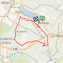
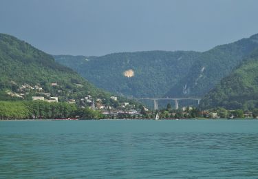
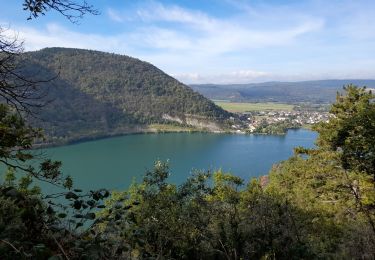
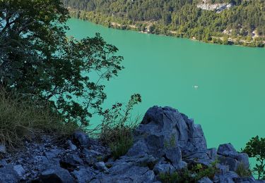
Randonnée Marche de 15 km à découvrir à Auvergne-Rhône-Alpes, Ain, Nantua. Cette randonnée est proposée par tgvpatrickfavre.
Description
départ nantua montée au signal chemin du milieu pour rejoindre la patte d oie aire parapente retour nantua par chemin de chamoise
Localisation
Pays :
France
Région :
Auvergne-Rhône-Alpes
Département/Province :
Ain
Commune :
Nantua
Localité :
Unknown
Départ:(Dec)
Départ:(UTM)
700760 ; 5114261 (31T) N.
Commentaires
Randonnées à proximité
![Randonnée Marche Port - le signal - Photo](https://media.geolcdn.com/t/375/260/ext.jpg?maxdim=2&url=https%3A%2F%2Fstatic1.geolcdn.com%2Fsiteimages%2Fupload%2Ffiles%2F1553511878bg_sport_marche.png)
![Marche Marche](https://static1.geolcdn.com/sitytour/trail-icons/101.png)
le signal
Marche
Moyen
(2)
Port,
Auvergne-Rhône-Alpes,
Ain,
France
![](/images/other/stat-length.png)
12,1 km | 24 km-effort
3h 45min
![](https://static1.geolcdn.com/siteimages/upload/files/16400158638029165_repeat_loop_refresh_sync_direction_icon.png)
Oui
![Randonnée Marche Nantua - nantua les monts d ain - Photo](https://media.geolcdn.com/t/375/260/77fcf02f-ad15-4e21-909b-2ea8b6d60d5c.jpg&format=jpg&maxdim=2)
![Marche Marche](https://static1.geolcdn.com/sitytour/trail-icons/101.png)
nantua les monts d ain
Marche
Difficile
(1)
Nantua,
Auvergne-Rhône-Alpes,
Ain,
France
![](/images/other/stat-length.png)
14,6 km | 24 km-effort
5h 45min
![](https://static1.geolcdn.com/siteimages/upload/files/16400158638029165_repeat_loop_refresh_sync_direction_icon.png)
Oui
![Randonnée Marche Maillat - la boucle de maillat - Photo](https://media.geolcdn.com/t/375/260/7ee51dff-9cc5-452e-8296-9b5e76dea70c.jpg&format=jpg&maxdim=2)
![Marche Marche](https://static1.geolcdn.com/sitytour/trail-icons/101.png)
la boucle de maillat
Marche
Moyen
Maillat,
Auvergne-Rhône-Alpes,
Ain,
France
![](/images/other/stat-length.png)
12,5 km | 16,3 km-effort
3h 23min
![](https://static1.geolcdn.com/siteimages/upload/files/16400158638029165_repeat_loop_refresh_sync_direction_icon.png)
Oui
![Randonnée A pied Nantua - Tour des Fècles - Photo](https://media.geolcdn.com/t/375/260/217fffb5-bcb6-404e-81a5-c54375b57d30.jpeg&format=jpg&maxdim=2)
![A pied A pied](https://static1.geolcdn.com/sitytour/trail-icons/100.png)
Tour des Fècles
A pied
Facile
Nantua,
Auvergne-Rhône-Alpes,
Ain,
France
![](/images/other/stat-length.png)
9 km | 15,5 km-effort
3h 30min
![](https://static1.geolcdn.com/siteimages/upload/files/16400158638029165_repeat_loop_refresh_sync_direction_icon.png)
Oui
![Randonnée A pied Nantua - Tour d'Horizon - Photo](https://media.geolcdn.com/t/375/260/2e036bc7-25b5-4747-803f-81065f60a4b3.jpeg&format=jpg&maxdim=2)
![A pied A pied](https://static1.geolcdn.com/sitytour/trail-icons/100.png)
Tour d'Horizon
A pied
Facile
Nantua,
Auvergne-Rhône-Alpes,
Ain,
France
![](/images/other/stat-length.png)
5,5 km | 7,8 km-effort
1h 46min
![](https://static1.geolcdn.com/siteimages/upload/files/16400158638029165_repeat_loop_refresh_sync_direction_icon.png)
Non
![Randonnée A pied Montréal-la-Cluse - Voiles du Landeyron - Photo](https://media.geolcdn.com/t/375/260/63876335-79d5-4574-8748-2c039a5fa728.jpeg&format=jpg&maxdim=2)
![A pied A pied](https://static1.geolcdn.com/sitytour/trail-icons/100.png)
Voiles du Landeyron
A pied
Facile
Montréal-la-Cluse,
Auvergne-Rhône-Alpes,
Ain,
France
![](/images/other/stat-length.png)
3,7 km | 6,4 km-effort
1h 27min
![](https://static1.geolcdn.com/siteimages/upload/files/16400158638029165_repeat_loop_refresh_sync_direction_icon.png)
Non
![Randonnée A pied Charix - Tour du Crêt Torcet - Photo](https://media.geolcdn.com/t/375/260/4d19b8c6-fb43-466a-bb34-4de8823c00a3.jpeg&format=jpg&maxdim=2)
![A pied A pied](https://static1.geolcdn.com/sitytour/trail-icons/100.png)
Tour du Crêt Torcet
A pied
Facile
Charix,
Auvergne-Rhône-Alpes,
Ain,
France
![](/images/other/stat-length.png)
12,4 km | 17,7 km-effort
4h 1min
![](https://static1.geolcdn.com/siteimages/upload/files/16400158638029165_repeat_loop_refresh_sync_direction_icon.png)
Oui
![Randonnée Marche Nantua - AIN / NANTUA: MARIA MATRE - LES FECLES - LA COLONNE - LE MONTOUX - Photo](https://media.geolcdn.com/t/375/260/a076f92a-4e8b-4c54-8f15-a609a62f5769.jpg&format=jpg&maxdim=2)
![Marche Marche](https://static1.geolcdn.com/sitytour/trail-icons/101.png)
AIN / NANTUA: MARIA MATRE - LES FECLES - LA COLONNE - LE MONTOUX
Marche
Moyen
Nantua,
Auvergne-Rhône-Alpes,
Ain,
France
![](/images/other/stat-length.png)
14,6 km | 23 km-effort
5h 0min
![](https://static1.geolcdn.com/siteimages/upload/files/16400158638029165_repeat_loop_refresh_sync_direction_icon.png)
Oui
![Randonnée Marche Nantua - Nantua via roche du diable - Photo](https://media.geolcdn.com/t/375/260/0d2529d2-b863-47f6-8607-0a31411d02dc.jpg&format=jpg&maxdim=2)
![Marche Marche](https://static1.geolcdn.com/sitytour/trail-icons/101.png)
Nantua via roche du diable
Marche
Moyen
Nantua,
Auvergne-Rhône-Alpes,
Ain,
France
![](/images/other/stat-length.png)
6,5 km | 10,8 km-effort
1h 35min
![](https://static1.geolcdn.com/siteimages/upload/files/16400158638029165_repeat_loop_refresh_sync_direction_icon.png)
Non