![](/images/other/stat-length.png)
![Randonnée Marche Vieil-Hesdin - Vieil-Hesdin. Sentier Le Charles Quint - Photo](https://media.geolcdn.com/t/1900/400/ext.pjpeg?maxdim=2&url=https%3A%2F%2Fstatic1.geolcdn.com%2Fsiteimages%2Fupload%2Ffiles%2F1553511878bg_sport_marche.png)
Vieil-Hesdin. Sentier Le Charles Quint
papiou
Utilisateur
![Longueur](/images/other/stat-length.png)
Longueur
13,9 km
![Altitude max](https://static1.geolcdn.com/siteimages/upload/files/1508320355ic_sort_altitude_max_24dp.png)
Altitude max
132 m
![Dénivelé positif](https://static1.geolcdn.com/siteimages/upload/files/1508320355ic_sort_den_pos_24dp.png)
Dénivelé positif
156 m
![Km-Effort](/images/other/stat-length.png)
Km-Effort
16 km
![Altitude min](https://static1.geolcdn.com/siteimages/upload/files/1508320355ic_sort_altitude_min_24dp.png)
Altitude min
33 m
![Dénivelé négatif](https://static1.geolcdn.com/siteimages/upload/files/1508320355ic_sort_den_neg_24dp.png)
Dénivelé négatif
157 m
![Boucle](https://static1.geolcdn.com/siteimages/upload/files/16400158638029165_repeat_loop_refresh_sync_direction_icon.png)
Boucle
Oui
Date de création :
2016-05-19 00:00:00.0
Dernière modification :
2016-05-19 00:00:00.0
![Marche](https://static1.geolcdn.com/sitytour/trail-icons/101.png)
3h44
Difficulté : Moyen
![Scannez ce code QR pour ouvrir la randonnée dans l'application SityTrail](https://capi.geolives.com/qq0zvz2zws4bq2lad0pu/sitytour/trails/571535/qr.png?size=200)
Application GPS de randonnée GRATUITE
À propos
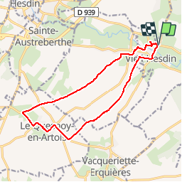
Randonnée Marche de 13,9 km à découvrir à Hauts-de-France, Pas-de-Calais, Vieil-Hesdin. Cette randonnée est proposée par papiou.
Description
Rdv église sur le parking de côté. prendre chemin à droite et suivre le balisage. attention après ancien monastère prendre à gauche. Pour manger sur le circuit partir vers 10 h00 je rejoindre village Quesnoy pour 12 h 00
Localisation
Pays :
France
Région :
Hauts-de-France
Département/Province :
Pas-de-Calais
Commune :
Vieil-Hesdin
Localité :
Unknown
Départ:(Dec)
Départ:(UTM)
436115 ; 5579076 (31U) N.
Commentaires
Randonnées à proximité
![Randonnée Marche Galametz - GALAMETZ Le Mont de Wail - Photo](https://media.geolcdn.com/t/375/260/77be3de3-8192-4488-b457-f0af3c10dd5e.jpg&format=jpg&maxdim=2)
![Marche Marche](https://static1.geolcdn.com/sitytour/trail-icons/101.png)
GALAMETZ Le Mont de Wail
Marche
Difficile
Galametz,
Hauts-de-France,
Pas-de-Calais,
France
![](/images/other/stat-length.png)
13,6 km | 16,5 km-effort
3h 45min
![](https://static1.geolcdn.com/siteimages/upload/files/16400158638029165_repeat_loop_refresh_sync_direction_icon.png)
Oui
![Randonnée Marche Huby-Saint-Leu - Huby 3 matin - Photo](https://media.geolcdn.com/t/375/260/ext.jpg?maxdim=2&url=https%3A%2F%2Fstatic1.geolcdn.com%2Fsiteimages%2Fupload%2Ffiles%2F1553511878bg_sport_marche.png)
![Marche Marche](https://static1.geolcdn.com/sitytour/trail-icons/101.png)
Huby 3 matin
Marche
Moyen
Huby-Saint-Leu,
Hauts-de-France,
Pas-de-Calais,
France
![](/images/other/stat-length.png)
5,9 km | 8,2 km-effort
2h 53min
![](https://static1.geolcdn.com/siteimages/upload/files/16400158638029165_repeat_loop_refresh_sync_direction_icon.png)
Oui
![Randonnée Marche Huby-Saint-Leu - ehpad hesdin - Photo](https://media.geolcdn.com/t/375/260/ext.jpg?maxdim=2&url=https%3A%2F%2Fstatic1.geolcdn.com%2Fsiteimages%2Fupload%2Ffiles%2F1553511878bg_sport_marche.png)
![Marche Marche](https://static1.geolcdn.com/sitytour/trail-icons/101.png)
ehpad hesdin
Marche
Très facile
Huby-Saint-Leu,
Hauts-de-France,
Pas-de-Calais,
France
![](/images/other/stat-length.png)
3,1 km | 3,3 km-effort
46min
![](https://static1.geolcdn.com/siteimages/upload/files/16400158638029165_repeat_loop_refresh_sync_direction_icon.png)
Oui
![Randonnée Marche Huby-Saint-Leu - Forêt d'Hesdin - Photo](https://media.geolcdn.com/t/375/260/ext.jpg?maxdim=2&url=https%3A%2F%2Fstatic1.geolcdn.com%2Fsiteimages%2Fupload%2Ffiles%2F1553511878bg_sport_marche.png)
![Marche Marche](https://static1.geolcdn.com/sitytour/trail-icons/101.png)
Forêt d'Hesdin
Marche
Facile
Huby-Saint-Leu,
Hauts-de-France,
Pas-de-Calais,
France
![](/images/other/stat-length.png)
27 km | 33 km-effort
6h 15min
![](https://static1.geolcdn.com/siteimages/upload/files/16400158638029165_repeat_loop_refresh_sync_direction_icon.png)
Oui
![Randonnée Marche Huby-Saint-Leu - Balade en Foret d'Hesdin - Photo](https://media.geolcdn.com/t/375/260/ext.jpg?maxdim=2&url=https%3A%2F%2Fstatic1.geolcdn.com%2Fsiteimages%2Fupload%2Ffiles%2F1553511878bg_sport_marche.png)
![Marche Marche](https://static1.geolcdn.com/sitytour/trail-icons/101.png)
Balade en Foret d'Hesdin
Marche
Moyen
Huby-Saint-Leu,
Hauts-de-France,
Pas-de-Calais,
France
![](/images/other/stat-length.png)
11,4 km | 14,6 km-effort
2h 30min
![](https://static1.geolcdn.com/siteimages/upload/files/16400158638029165_repeat_loop_refresh_sync_direction_icon.png)
Oui
![Randonnée Randonnée équestre Huby-Saint-Leu - Huby St Leu - Photo](https://media.geolcdn.com/t/375/260/ext.jpg?maxdim=2&url=https%3A%2F%2Fstatic1.geolcdn.com%2Fsiteimages%2Fupload%2Ffiles%2F1524743154cheval.jpg)
![Randonnée équestre Randonnée équestre](https://static1.geolcdn.com/sitytour/trail-icons/301.png)
Huby St Leu
Randonnée équestre
Moyen
Huby-Saint-Leu,
Hauts-de-France,
Pas-de-Calais,
France
![](/images/other/stat-length.png)
15,9 km | 21 km-effort
2h 44min
![](https://static1.geolcdn.com/siteimages/upload/files/16400158638029165_repeat_loop_refresh_sync_direction_icon.png)
Oui
![Randonnée Marche Huby-Saint-Leu - Forêt D'Hesdin - Photo](https://media.geolcdn.com/t/375/260/ext.jpg?maxdim=2&url=https%3A%2F%2Fstatic1.geolcdn.com%2Fsiteimages%2Fupload%2Ffiles%2F1553511878bg_sport_marche.png)
![Marche Marche](https://static1.geolcdn.com/sitytour/trail-icons/101.png)
Forêt D'Hesdin
Marche
Difficile
Huby-Saint-Leu,
Hauts-de-France,
Pas-de-Calais,
France
![](/images/other/stat-length.png)
10 km | 12,9 km-effort
1h 57min
![](https://static1.geolcdn.com/siteimages/upload/files/16400158638029165_repeat_loop_refresh_sync_direction_icon.png)
Oui
![Randonnée Marche Huby-Saint-Leu - Forêt de Hesdin - Photo](https://media.geolcdn.com/t/375/260/ext.jpg?maxdim=2&url=https%3A%2F%2Fstatic1.geolcdn.com%2Fsiteimages%2Fupload%2Ffiles%2F1553511878bg_sport_marche.png)
![Marche Marche](https://static1.geolcdn.com/sitytour/trail-icons/101.png)
Forêt de Hesdin
Marche
Facile
Huby-Saint-Leu,
Hauts-de-France,
Pas-de-Calais,
France
![](/images/other/stat-length.png)
8,1 km | 11,2 km-effort
2h 5min
![](https://static1.geolcdn.com/siteimages/upload/files/16400158638029165_repeat_loop_refresh_sync_direction_icon.png)
Oui
![Randonnée Marche Huby-Saint-Leu - Forêt de Hesdin - Photo](https://media.geolcdn.com/t/375/260/ext.jpg?maxdim=2&url=https%3A%2F%2Fstatic1.geolcdn.com%2Fsiteimages%2Fupload%2Ffiles%2F1553511878bg_sport_marche.png)
![Marche Marche](https://static1.geolcdn.com/sitytour/trail-icons/101.png)
Forêt de Hesdin
Marche
Moyen
(1)
Huby-Saint-Leu,
Hauts-de-France,
Pas-de-Calais,
France
![](/images/other/stat-length.png)
11,2 km | 14,6 km-effort
3h 7min
![](https://static1.geolcdn.com/siteimages/upload/files/16400158638029165_repeat_loop_refresh_sync_direction_icon.png)
Oui