![](/images/other/stat-length.png)
![Randonnée Vélo Capbreton - Entre Capbreton et labenne Océan - Photo](https://media.geolcdn.com/t/1900/400/ext.pjpeg?maxdim=2&url=https%3A%2F%2Fstatic1.geolcdn.com%2Fsiteimages%2Fupload%2Ffiles%2F1524743154velo.jpg)
Entre Capbreton et labenne Océan
randotines
Utilisateur GUIDE
![Longueur](/images/other/stat-length.png)
Longueur
23 km
![Altitude max](https://static1.geolcdn.com/siteimages/upload/files/1508320355ic_sort_altitude_max_24dp.png)
Altitude max
14 m
![Dénivelé positif](https://static1.geolcdn.com/siteimages/upload/files/1508320355ic_sort_den_pos_24dp.png)
Dénivelé positif
131 m
![Km-Effort](/images/other/stat-length.png)
Km-Effort
25 km
![Altitude min](https://static1.geolcdn.com/siteimages/upload/files/1508320355ic_sort_altitude_min_24dp.png)
Altitude min
-3 m
![Dénivelé négatif](https://static1.geolcdn.com/siteimages/upload/files/1508320355ic_sort_den_neg_24dp.png)
Dénivelé négatif
131 m
![Boucle](https://static1.geolcdn.com/siteimages/upload/files/16400158638029165_repeat_loop_refresh_sync_direction_icon.png)
Boucle
Oui
Date de création :
2016-05-17 00:00:00.0
Dernière modification :
2016-05-17 00:00:00.0
![Vélo](https://static1.geolcdn.com/sitytour/trail-icons/200.png)
1h27
Difficulté : Très facile
![Scannez ce code QR pour ouvrir la randonnée dans l'application SityTrail](https://capi.geolives.com/qq0zvz2zws4bq2lad0pu/sitytour/trails/570809/qr.png?size=200)
Application GPS de randonnée GRATUITE
À propos
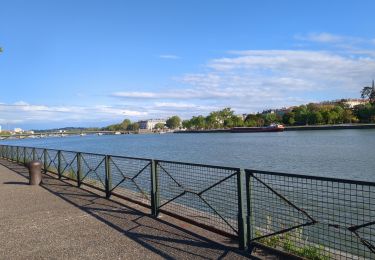
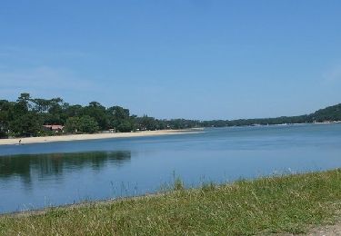
Randonnée Vélo de 23 km à découvrir à Nouvelle-Aquitaine, Landes, Capbreton. Cette randonnée est proposée par randotines.
Description
Découverte de Capbreton par les très belles pistes cyclables puis direction plein sud pour longer le Boudigau ( rivière ) par la voie verte
Localisation
Pays :
France
Région :
Nouvelle-Aquitaine
Département/Province :
Landes
Commune :
Capbreton
Localité :
Unknown
Départ:(Dec)
Départ:(UTM)
625268 ; 4832693 (30T) N.
Commentaires
Randonnées à proximité
![Randonnée Marche Soorts-Hossegor - étape 6 Compostelle 24 - Photo](https://media.geolcdn.com/t/375/260/bbba3ec7-0e64-4ae7-8771-4d741d9b8c32.jpg&format=jpg&maxdim=2)
![Marche Marche](https://static1.geolcdn.com/sitytour/trail-icons/101.png)
étape 6 Compostelle 24
Marche
Moyen
Soorts-Hossegor,
Nouvelle-Aquitaine,
Landes,
France
![](/images/other/stat-length.png)
24 km | 26 km-effort
9h 14min
![](https://static1.geolcdn.com/siteimages/upload/files/16400158638029165_repeat_loop_refresh_sync_direction_icon.png)
Non
![Randonnée V.T.T. Soorts-Hossegor - Boucle Seignosse - Souston - Photo](https://media.geolcdn.com/t/375/260/df9b1316-d8b4-4213-b113-4702b3b51131.jpg&format=jpg&maxdim=2)
![V.T.T. V.T.T.](https://static1.geolcdn.com/sitytour/trail-icons/202.png)
Boucle Seignosse - Souston
V.T.T.
Facile
Soorts-Hossegor,
Nouvelle-Aquitaine,
Landes,
France
![](/images/other/stat-length.png)
35 km | 40 km-effort
3h 20min
![](https://static1.geolcdn.com/siteimages/upload/files/16400158638029165_repeat_loop_refresh_sync_direction_icon.png)
Oui
![Randonnée V.T.T. Soorts-Hossegor - Soorts_Plage du Penon - Photo](https://media.geolcdn.com/t/375/260/ext.jpg?maxdim=2&url=https%3A%2F%2Fstatic1.geolcdn.com%2Fsiteimages%2Fupload%2Ffiles%2F1524743154velo.jpg)
![V.T.T. V.T.T.](https://static1.geolcdn.com/sitytour/trail-icons/202.png)
Soorts_Plage du Penon
V.T.T.
Moyen
(1)
Soorts-Hossegor,
Nouvelle-Aquitaine,
Landes,
France
![](/images/other/stat-length.png)
23 km | 27 km-effort
1h 52min
![](https://static1.geolcdn.com/siteimages/upload/files/16400158638029165_repeat_loop_refresh_sync_direction_icon.png)
Oui
![Randonnée Marche Soorts-Hossegor - 40 HOSSEGOR, parcours pédestres de la forêt d'Hossegor maison Hargous - Photo](https://media.geolcdn.com/t/375/260/ext.jpg?maxdim=2&url=https%3A%2F%2Fservices.sitytrail.com%2FGeolivesWS%2FDownloadMedia.ashx%3FTrailID%3D513647%26Media%3D20160117124315.jpg)
![Marche Marche](https://static1.geolcdn.com/sitytour/trail-icons/101.png)
40 HOSSEGOR, parcours pédestres de la forêt d'Hossegor maison Hargous
Marche
Facile
Soorts-Hossegor,
Nouvelle-Aquitaine,
Landes,
France
![](/images/other/stat-length.png)
5,3 km | 6,4 km-effort
1h 9min
![](https://static1.geolcdn.com/siteimages/upload/files/16400158638029165_repeat_loop_refresh_sync_direction_icon.png)
Oui
![Randonnée Marche Soorts-Hossegor - 40 SOORTS-HOSSEGOR, SEIGNOSSE. CAPBRETON, grand tour du Lac D'Hossegor - Photo](https://media.geolcdn.com/t/375/260/ext.jpg?maxdim=2&url=https%3A%2F%2Fservices.sitytrail.com%2FGeolivesWS%2FDownloadMedia.ashx%3FTrailID%3D512303%26Media%3D20160111164407.jpg)
![Marche Marche](https://static1.geolcdn.com/sitytour/trail-icons/101.png)
40 SOORTS-HOSSEGOR, SEIGNOSSE. CAPBRETON, grand tour du Lac D'Hossegor
Marche
Moyen
(1)
Soorts-Hossegor,
Nouvelle-Aquitaine,
Landes,
France
![](/images/other/stat-length.png)
13 km | 14,3 km-effort
3h 6min
![](https://static1.geolcdn.com/siteimages/upload/files/16400158638029165_repeat_loop_refresh_sync_direction_icon.png)
Oui
![Randonnée Marche Capbreton - 40 CAPBRETON, promenade entre canaux, ports, plages et centre ville - Photo](https://media.geolcdn.com/t/375/260/ext.jpg?maxdim=2&url=https%3A%2F%2Fservices.sitytrail.com%2FGeolivesWS%2FDownloadMedia.ashx%3FTrailID%3D512285%26Media%3D20160112145222.jpg)
![Marche Marche](https://static1.geolcdn.com/sitytour/trail-icons/101.png)
40 CAPBRETON, promenade entre canaux, ports, plages et centre ville
Marche
Facile
Capbreton,
Nouvelle-Aquitaine,
Landes,
France
![](/images/other/stat-length.png)
7,4 km | 7,9 km-effort
1h 41min
![](https://static1.geolcdn.com/siteimages/upload/files/16400158638029165_repeat_loop_refresh_sync_direction_icon.png)
Non
![Randonnée Marche Soorts-Hossegor - Hossegor le 15 09 2021 - Photo](https://media.geolcdn.com/t/375/260/88b0222e-e0be-485e-8c61-08fa5346c4c8.jpg&format=jpg&maxdim=2)
![Marche Marche](https://static1.geolcdn.com/sitytour/trail-icons/101.png)
Hossegor le 15 09 2021
Marche
Très facile
Soorts-Hossegor,
Nouvelle-Aquitaine,
Landes,
France
![](/images/other/stat-length.png)
6,5 km | 7,3 km-effort
1h 57min
![](https://static1.geolcdn.com/siteimages/upload/files/16400158638029165_repeat_loop_refresh_sync_direction_icon.png)
Oui
![Randonnée Vélo Capbreton - Entre Capbreton et Hossegor - Photo](https://media.geolcdn.com/t/375/260/ext.jpg?maxdim=2&url=https%3A%2F%2Fstatic1.geolcdn.com%2Fsiteimages%2Fupload%2Ffiles%2F1524743154velo.jpg)
![Vélo Vélo](https://static1.geolcdn.com/sitytour/trail-icons/200.png)
Entre Capbreton et Hossegor
Vélo
Facile
Capbreton,
Nouvelle-Aquitaine,
Landes,
France
![](/images/other/stat-length.png)
27 km | 29 km-effort
1h 43min
![](https://static1.geolcdn.com/siteimages/upload/files/16400158638029165_repeat_loop_refresh_sync_direction_icon.png)
Oui
![Randonnée Marche Soorts-Hossegor - Autour du lac marin d'Hossegor - Photo](https://media.geolcdn.com/t/375/260/ext.jpg?maxdim=2&url=https%3A%2F%2Fservices.sitytrail.com%2FGeolivesWS%2FDownloadMedia.ashx%3FTrailID%3D317428%26Media%3D16661_2.jpg)
![Marche Marche](https://static1.geolcdn.com/sitytour/trail-icons/101.png)
Autour du lac marin d'Hossegor
Marche
Facile
Soorts-Hossegor,
Nouvelle-Aquitaine,
Landes,
France
![](/images/other/stat-length.png)
7,4 km | 8,2 km-effort
2h 0min
![](https://static1.geolcdn.com/siteimages/upload/files/16400158638029165_repeat_loop_refresh_sync_direction_icon.png)
Oui