![](/images/other/stat-length.png)
![Randonnée Marche Bages - 66 BAGES promenade sur Les crêtes,Panorama sur les Albères, Et sur le lac de VILLENEUVE DE LA RAHO - Photo](https://media.geolcdn.com/t/1900/400/ext.pjpeg?maxdim=2&url=https%3A%2F%2Fstatic1.geolcdn.com%2Fsiteimages%2Fupload%2Ffiles%2F1553511878bg_sport_marche.png)
66 BAGES promenade sur Les crêtes,Panorama sur les Albères, Et sur le lac de VILLENEUVE DE LA RAHO
jeff66
Utilisateur
![Longueur](/images/other/stat-length.png)
Longueur
7,8 km
![Altitude max](https://static1.geolcdn.com/siteimages/upload/files/1508320355ic_sort_altitude_max_24dp.png)
Altitude max
46 m
![Dénivelé positif](https://static1.geolcdn.com/siteimages/upload/files/1508320355ic_sort_den_pos_24dp.png)
Dénivelé positif
76 m
![Km-Effort](/images/other/stat-length.png)
Km-Effort
8,8 km
![Altitude min](https://static1.geolcdn.com/siteimages/upload/files/1508320355ic_sort_altitude_min_24dp.png)
Altitude min
11 m
![Dénivelé négatif](https://static1.geolcdn.com/siteimages/upload/files/1508320355ic_sort_den_neg_24dp.png)
Dénivelé négatif
77 m
![Boucle](https://static1.geolcdn.com/siteimages/upload/files/16400158638029165_repeat_loop_refresh_sync_direction_icon.png)
Boucle
Oui
Date de création :
2016-05-17 00:00:00.0
Dernière modification :
2016-05-17 00:00:00.0
![Marche](https://static1.geolcdn.com/sitytour/trail-icons/101.png)
1h27
Difficulté : Facile
![Scannez ce code QR pour ouvrir la randonnée dans l'application SityTrail](https://capi.geolives.com/qq0zvz2zws4bq2lad0pu/sitytour/trails/568234/qr.png?size=200)
Application GPS de randonnée GRATUITE
À propos
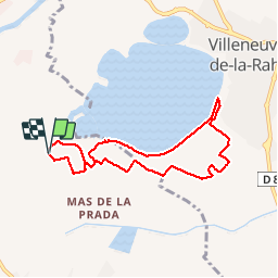
Randonnée Marche de 7,8 km à découvrir à Occitanie, Pyrénées-Orientales, Bages. Cette randonnée est proposée par jeff66.
Description
66 BAGES, Vulpillères, La Llantia, promenade sur Les crêtes,Panorama sur les Albères, Et sur le lac de VILLENEUVE DE LA RAHO, LA Sobrepera, Els Etanyots, Val Marie, stade - Salle polyvalente - Pétanque - tennis, Mas Doat, le Lac
Localisation
Pays :
France
Région :
Occitanie
Département/Province :
Pyrénées-Orientales
Commune :
Bages
Localité :
Unknown
Départ:(Dec)
Départ:(UTM)
490679 ; 4719102 (31T) N.
Commentaires
Randonnées à proximité
![Randonnée Quad Montescot - Villeneuve-de-la-Raho-Collioure (Septembre/Juin) - Photo](https://media.geolcdn.com/t/375/260/4ff70784-96c3-45ae-a310-36bc0ac2c85e.jpg&format=jpg&maxdim=2)
![Quad Quad](https://static1.geolcdn.com/sitytour/trail-icons/404.png)
Villeneuve-de-la-Raho-Collioure (Septembre/Juin)
Quad
Moyen
(1)
Montescot,
Occitanie,
Pyrénées-Orientales,
France
![](/images/other/stat-length.png)
33 km | 40 km-effort
1h 45min
![](https://static1.geolcdn.com/siteimages/upload/files/16400158638029165_repeat_loop_refresh_sync_direction_icon.png)
Non
![Randonnée Marche Montescot - 66 VILLENEUVE-DE-LA-RAHO grand tour du lac en Sens horaire - Photo](https://media.geolcdn.com/t/375/260/ext.jpg?maxdim=2&url=https%3A%2F%2Fservices.sitytrail.com%2FGeolivesWS%2FDownloadMedia.ashx%3FTrailID%3D526864%26Media%3D20160209171243.jpg)
![Marche Marche](https://static1.geolcdn.com/sitytour/trail-icons/101.png)
66 VILLENEUVE-DE-LA-RAHO grand tour du lac en Sens horaire
Marche
Facile
(1)
Montescot,
Occitanie,
Pyrénées-Orientales,
France
![](/images/other/stat-length.png)
6,7 km | 7,5 km-effort
1h 4min
![](https://static1.geolcdn.com/siteimages/upload/files/16400158638029165_repeat_loop_refresh_sync_direction_icon.png)
Oui
![Randonnée Marche Saint-Jean-Lasseille - ST-JEAN-LASSEILLE 66 - terroirs des Aspres - Photo](https://media.geolcdn.com/t/375/260/ext.jpg?maxdim=2&url=https%3A%2F%2Fservices.sitytrail.com%2FGeolivesWS%2FDownloadMedia.ashx%3FTrailID%3D419934%26Media%3D20150512183916.jpg)
![Marche Marche](https://static1.geolcdn.com/sitytour/trail-icons/101.png)
ST-JEAN-LASSEILLE 66 - terroirs des Aspres
Marche
Facile
(1)
Saint-Jean-Lasseille,
Occitanie,
Pyrénées-Orientales,
France
![](/images/other/stat-length.png)
12,2 km | 14,3 km-effort
2h 6min
![](https://static1.geolcdn.com/siteimages/upload/files/16400158638029165_repeat_loop_refresh_sync_direction_icon.png)
Oui
![Randonnée Marche Villeneuve-de-la-Raho - 66 VILLENEUVE-DE-LA-RAHO - grand tour périphérique du lac par les lignes de crêtes - Photo](https://media.geolcdn.com/t/375/260/ext.jpg?maxdim=2&url=https%3A%2F%2Fstatic1.geolcdn.com%2Fsiteimages%2Fupload%2Ffiles%2F1553511878bg_sport_marche.png)
![Marche Marche](https://static1.geolcdn.com/sitytour/trail-icons/101.png)
66 VILLENEUVE-DE-LA-RAHO - grand tour périphérique du lac par les lignes de c...
Marche
Facile
(2)
Villeneuve-de-la-Raho,
Occitanie,
Pyrénées-Orientales,
France
![](/images/other/stat-length.png)
10 km | 11,5 km-effort
1h 44min
![](https://static1.geolcdn.com/siteimages/upload/files/16400158638029165_repeat_loop_refresh_sync_direction_icon.png)
Oui
![Randonnée V.T.T. Canohès - canohes - Photo](https://media.geolcdn.com/t/375/260/ext.jpg?maxdim=2&url=https%3A%2F%2Fstatic1.geolcdn.com%2Fsiteimages%2Fupload%2Ffiles%2F1524743154velo.jpg)
![V.T.T. V.T.T.](https://static1.geolcdn.com/sitytour/trail-icons/202.png)
canohes
V.T.T.
Moyen
(2)
Canohès,
Occitanie,
Pyrénées-Orientales,
France
![](/images/other/stat-length.png)
37 km | 44 km-effort
2h 12min
![](https://static1.geolcdn.com/siteimages/upload/files/16400158638029165_repeat_loop_refresh_sync_direction_icon.png)
Oui
![Randonnée Quad Villeneuve-de-la-Raho - Villeneuve-de-la-Raho-Collioure(Juillet-Aout) - Photo](https://media.geolcdn.com/t/375/260/94b9111a-30bb-4d36-9ee6-84d7d83dae26.jpg&format=jpg&maxdim=2)
![Quad Quad](https://static1.geolcdn.com/sitytour/trail-icons/404.png)
Villeneuve-de-la-Raho-Collioure(Juillet-Aout)
Quad
Très facile
(1)
Villeneuve-de-la-Raho,
Occitanie,
Pyrénées-Orientales,
France
![](/images/other/stat-length.png)
39 km | 44 km-effort
1h 40min
![](https://static1.geolcdn.com/siteimages/upload/files/16400158638029165_repeat_loop_refresh_sync_direction_icon.png)
Non
![Randonnée Marche Perpignan - Perpignan - Photo](https://media.geolcdn.com/t/375/260/904ff4bb-4f73-47d8-906f-dc7922d74f80.jpg&format=jpg&maxdim=2)
![Marche Marche](https://static1.geolcdn.com/sitytour/trail-icons/101.png)
Perpignan
Marche
Très facile
Perpignan,
Occitanie,
Pyrénées-Orientales,
France
![](/images/other/stat-length.png)
18 km | 19,9 km-effort
2h 23min
![](https://static1.geolcdn.com/siteimages/upload/files/16400158638029165_repeat_loop_refresh_sync_direction_icon.png)
Non
![Randonnée Marche Perpignan - canal Perpignan - Photo](https://media.geolcdn.com/t/375/260/ext.jpg?maxdim=2&url=https%3A%2F%2Fservices.sitytrail.com%2FGeolivesWS%2FDownloadMedia.ashx%3FTrailID%3D745865%26Media%3Dfix__20170316151123.jpg)
![Marche Marche](https://static1.geolcdn.com/sitytour/trail-icons/101.png)
canal Perpignan
Marche
Très facile
Perpignan,
Occitanie,
Pyrénées-Orientales,
France
![](/images/other/stat-length.png)
25 km | 27 km-effort
7h 29min
![](https://static1.geolcdn.com/siteimages/upload/files/16400158638029165_repeat_loop_refresh_sync_direction_icon.png)
Non
![Randonnée Marche Montescot - 66 VILLENEUVE-DE-LA-RAHO grand tour du lac en Sens horaire - Photo](https://media.geolcdn.com/t/375/260/ext.jpg?maxdim=2&url=https%3A%2F%2Fservices.sitytrail.com%2FGeolivesWS%2FDownloadMedia.ashx%3FTrailID%3D534696%26Media%3D20160209172607.jpg)
![Marche Marche](https://static1.geolcdn.com/sitytour/trail-icons/101.png)
66 VILLENEUVE-DE-LA-RAHO grand tour du lac en Sens horaire
Marche
Facile
Montescot,
Occitanie,
Pyrénées-Orientales,
France
![](/images/other/stat-length.png)
6,7 km | 7,5 km-effort
1h 4min
![](https://static1.geolcdn.com/siteimages/upload/files/16400158638029165_repeat_loop_refresh_sync_direction_icon.png)
Oui