![](/images/other/stat-length.png)
![Randonnée V.T.T. Habscht - Hobscheid S 37km 2016 - Photo](https://media.geolcdn.com/t/1900/400/ext.pjpeg?maxdim=2&url=https%3A%2F%2Fstatic1.geolcdn.com%2Fsiteimages%2Fupload%2Ffiles%2F1524743154velo.jpg)
Hobscheid S 37km 2016
Ricco57
Utilisateur
![Longueur](/images/other/stat-length.png)
Longueur
37 km
![Altitude max](https://static1.geolcdn.com/siteimages/upload/files/1508320355ic_sort_altitude_max_24dp.png)
Altitude max
403 m
![Dénivelé positif](https://static1.geolcdn.com/siteimages/upload/files/1508320355ic_sort_den_pos_24dp.png)
Dénivelé positif
929 m
![Km-Effort](/images/other/stat-length.png)
Km-Effort
49 km
![Altitude min](https://static1.geolcdn.com/siteimages/upload/files/1508320355ic_sort_altitude_min_24dp.png)
Altitude min
275 m
![Dénivelé négatif](https://static1.geolcdn.com/siteimages/upload/files/1508320355ic_sort_den_neg_24dp.png)
Dénivelé négatif
934 m
![Boucle](https://static1.geolcdn.com/siteimages/upload/files/16400158638029165_repeat_loop_refresh_sync_direction_icon.png)
Boucle
Non
Date de création :
2016-05-09 00:00:00.0
Dernière modification :
2016-05-09 00:00:00.0
![V.T.T.](https://static1.geolcdn.com/sitytour/trail-icons/202.png)
2h24
Difficulté : Difficile
![Scannez ce code QR pour ouvrir la randonnée dans l'application SityTrail](https://capi.geolives.com/qq0zvz2zws4bq2lad0pu/sitytour/trails/566131/qr.png?size=200)
Application GPS de randonnée GRATUITE
À propos
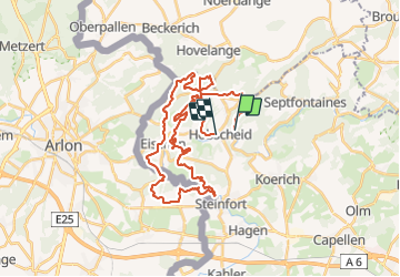
Randonnée V.T.T. de 37 km à découvrir à Inconnu, Canton Capellen, Habscht. Cette randonnée est proposée par Ricco57.
Description
Très beau parcours avec de belle descentes, des track superbe. Quelques passages difficiles et technique... Ouuuui! Vivement la prochaine...
Localisation
Pays :
Luxembourg
Région :
Inconnu
Département/Province :
Canton Capellen
Commune :
Habscht
Localité :
Hobscheid
Départ:(Dec)
Départ:(UTM)
710799 ; 5508195 (31U) N.
Commentaires
Randonnées à proximité
![Randonnée Marche Arlon - Clairefontaine - Circuit Natura 2000, des sites qui valent le détour - Lx15 - Photo](https://media.geolcdn.com/t/375/260/ext.jpg?maxdim=2&url=https%3A%2F%2Fservices.sitytrail.com%2FGeolivesWS%2FDownloadMedia.ashx%3FTrailID%3D333331%26Media%3D011bab6f-c149-41bf-be76-696578f9f696.JPG)
![Marche Marche](https://static1.geolcdn.com/sitytour/trail-icons/101.png)
Clairefontaine - Circuit Natura 2000, des sites qui valent le détour - Lx15
Marche
Facile
(2)
Arlon,
Wallonie,
Luxembourg,
Belgique
![](/images/other/stat-length.png)
4,1 km | 5,3 km-effort
1h 11min
![](https://static1.geolcdn.com/siteimages/upload/files/16400158638029165_repeat_loop_refresh_sync_direction_icon.png)
Oui
![Randonnée Marche Arlon - Guirsch, vallée des moulins - Photo](https://media.geolcdn.com/t/375/260/ext.jpg?maxdim=2&url=https%3A%2F%2Fservices.sitytrail.com%2FGeolivesWS%2FDownloadMedia.ashx%3FTrailID%3D462490%26Media%3Dfix__20150822151852.jpg)
![Marche Marche](https://static1.geolcdn.com/sitytour/trail-icons/101.png)
Guirsch, vallée des moulins
Marche
Très facile
(1)
Arlon,
Wallonie,
Luxembourg,
Belgique
![](/images/other/stat-length.png)
5,8 km | 7,2 km-effort
1h 33min
![](https://static1.geolcdn.com/siteimages/upload/files/16400158638029165_repeat_loop_refresh_sync_direction_icon.png)
Non
![Randonnée Marche Habscht - Tunnel Tour - Photo](https://media.geolcdn.com/t/375/260/82720245-2ef9-4a0b-a9f7-0bd828756b2c.jpg&format=jpg&maxdim=2)
![Marche Marche](https://static1.geolcdn.com/sitytour/trail-icons/101.png)
Tunnel Tour
Marche
Moyen
(1)
Habscht,
Inconnu,
Canton Capellen,
Luxembourg
![](/images/other/stat-length.png)
4,2 km | 6,2 km-effort
1h 24min
![](https://static1.geolcdn.com/siteimages/upload/files/16400158638029165_repeat_loop_refresh_sync_direction_icon.png)
Oui
![Randonnée Marche Arlon - RF-Lu-15 - Une randonnée (trans)frontalière : Clairefontaine - Photo](https://media.geolcdn.com/t/375/260/ext.jpg?maxdim=2&url=https%3A%2F%2Fstatic1.geolcdn.com%2Fsiteimages%2Fupload%2Ffiles%2F1553511878bg_sport_marche.png)
![Marche Marche](https://static1.geolcdn.com/sitytour/trail-icons/101.png)
RF-Lu-15 - Une randonnée (trans)frontalière : Clairefontaine
Marche
Très facile
(3)
Arlon,
Wallonie,
Luxembourg,
Belgique
![](/images/other/stat-length.png)
11,1 km | 14,7 km-effort
3h 11min
![](https://static1.geolcdn.com/siteimages/upload/files/16400158638029165_repeat_loop_refresh_sync_direction_icon.png)
Oui
![Randonnée A pied Arlon - N° 8 - Waltzing-Eischen, balade belgo-luxembourgeoise - Photo](https://media.geolcdn.com/t/375/260/b0eed337-7084-4191-bc62-985346659136.jpeg&format=jpg&maxdim=2)
![A pied A pied](https://static1.geolcdn.com/sitytour/trail-icons/100.png)
N° 8 - Waltzing-Eischen, balade belgo-luxembourgeoise
A pied
Facile
Arlon,
Wallonie,
Luxembourg,
Belgique
![](/images/other/stat-length.png)
10,3 km | 13 km-effort
2h 57min
![](https://static1.geolcdn.com/siteimages/upload/files/16400158638029165_repeat_loop_refresh_sync_direction_icon.png)
Oui
![Randonnée A pied Arlon - N° 10 - Clairefontaine : Ermesinde - Photo](https://media.geolcdn.com/t/375/260/06dc8e88-1074-4dc8-92e2-176257711686.jpeg&format=jpg&maxdim=2)
![A pied A pied](https://static1.geolcdn.com/sitytour/trail-icons/100.png)
N° 10 - Clairefontaine : Ermesinde
A pied
Facile
Arlon,
Wallonie,
Luxembourg,
Belgique
![](/images/other/stat-length.png)
4 km | 5,1 km-effort
1h 9min
![](https://static1.geolcdn.com/siteimages/upload/files/16400158638029165_repeat_loop_refresh_sync_direction_icon.png)
Oui
![Randonnée A pied Arlon - N° 7 - Clairefontaine - L'Eisch - Photo](https://media.geolcdn.com/t/375/260/06dc8e88-1074-4dc8-92e2-176257711686.jpeg&format=jpg&maxdim=2)
![A pied A pied](https://static1.geolcdn.com/sitytour/trail-icons/100.png)
N° 7 - Clairefontaine - L'Eisch
A pied
Facile
Arlon,
Wallonie,
Luxembourg,
Belgique
![](/images/other/stat-length.png)
4,1 km | 5,4 km-effort
1h 13min
![](https://static1.geolcdn.com/siteimages/upload/files/16400158638029165_repeat_loop_refresh_sync_direction_icon.png)
Oui
![Randonnée A pied Beckerich - Auto-Pedestre Beckerich - Photo](https://media.geolcdn.com/t/375/260/e2b91b31-ee5a-41a2-b3de-375bce3c0b8f.jpeg&format=jpg&maxdim=2)
![A pied A pied](https://static1.geolcdn.com/sitytour/trail-icons/100.png)
Auto-Pedestre Beckerich
A pied
Facile
Beckerich,
Inconnu,
Canton Redange,
Luxembourg
![](/images/other/stat-length.png)
11,6 km | 15,5 km-effort
3h 30min
![](https://static1.geolcdn.com/siteimages/upload/files/16400158638029165_repeat_loop_refresh_sync_direction_icon.png)
Oui
![Randonnée A pied Arlon - Steinfort 1 - Photo](https://media.geolcdn.com/t/375/260/31cbcc06-04c7-4d6a-acf8-cc6973590a10.jpeg&format=jpg&maxdim=2)
![A pied A pied](https://static1.geolcdn.com/sitytour/trail-icons/100.png)