![](/images/other/stat-length.png)
![Randonnée Marche Cassis - Rando Cassis - Calanques d'En Vau, Port Pin et Port Miou - Photo](https://media.geolcdn.com/t/1900/400/ext.pjpeg?maxdim=2&url=https%3A%2F%2Fservices.sitytrail.com%2FGeolivesWS%2FDownloadMedia.ashx%3FTrailID%3D563871%26Media%3D4a25878b-a2f7-46c4-ac52-b55ff59fafa3.jpg)
Rando Cassis - Calanques d'En Vau, Port Pin et Port Miou
lauramb
Utilisateur
![Longueur](/images/other/stat-length.png)
![Altitude max](https://static1.geolcdn.com/siteimages/upload/files/1508320355ic_sort_altitude_max_24dp.png)
![Dénivelé positif](https://static1.geolcdn.com/siteimages/upload/files/1508320355ic_sort_den_pos_24dp.png)
![Km-Effort](/images/other/stat-length.png)
![Altitude min](https://static1.geolcdn.com/siteimages/upload/files/1508320355ic_sort_altitude_min_24dp.png)
![Dénivelé négatif](https://static1.geolcdn.com/siteimages/upload/files/1508320355ic_sort_den_neg_24dp.png)
![Boucle](https://static1.geolcdn.com/siteimages/upload/files/16400158638029165_repeat_loop_refresh_sync_direction_icon.png)
![Marche](https://static1.geolcdn.com/sitytour/trail-icons/101.png)
4h00
Difficulté : Difficile
![Scannez ce code QR pour ouvrir la randonnée dans l'application SityTrail](https://capi.geolives.com/qq0zvz2zws4bq2lad0pu/sitytour/trails/563871/qr.png?size=200)
Application GPS de randonnée GRATUITE
À propos
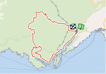
Randonnée Marche de 11,3 km à découvrir à Provence-Alpes-Côte d'Azur, Bouches-du-Rhône, Cassis. Cette randonnée est proposée par lauramb.
Description
Très belle randonnée dans les calanques d'en Vau, Port Pin et Port Miou, avec vues sur les falaises et la mer bien sur, le cap Canaille, l'île Riou, l'île Calsereigne ou île plane et l'île de Jarre. Pour ceux qui veulent se baigner porter le maillot, et n'oubliez pas votre appareil photo. La partie la plus difficile est la remontée d'en Vau jusqu'au plateau de la forêt de la Fontasse avec une pente importante dans un chemin caillouteux puis dans les rochers. La descente sur Port Miou bien que dans les rochers ne présente que peu de difficultés. D’autres informations sur le site de Rando Loisirs à Carnoux en Provence.
Localisation
Commentaires
Randonnées à proximité
![Randonnée Vélo de route Cassis - Marseille Cassis Route - Photo](https://media.geolcdn.com/t/375/260/3a21b855-f65e-4548-9ca8-5f083c8a8d79.jpg&format=jpg&maxdim=2)
![Vélo de route Vélo de route](https://static1.geolcdn.com/sitytour/trail-icons/201.png)
Vélo de route
![](/images/other/stat-length.png)
![](https://static1.geolcdn.com/siteimages/upload/files/16400158638029165_repeat_loop_refresh_sync_direction_icon.png)
![Marche Marche](https://static1.geolcdn.com/sitytour/trail-icons/101.png)
Marche
![](/images/other/stat-length.png)
![](https://static1.geolcdn.com/siteimages/upload/files/16400158638029165_repeat_loop_refresh_sync_direction_icon.png)
![Randonnée Marche Cassis - Les 3 Calanques coté Est - Port Miou - En Vau - Port Pin (2eme version) - Photo](https://media.geolcdn.com/t/375/260/6c8be29c-e655-4254-9b79-f66629a31e7b.jpg&format=jpg&maxdim=2)
![Marche Marche](https://static1.geolcdn.com/sitytour/trail-icons/101.png)
Marche
![](/images/other/stat-length.png)
![](https://static1.geolcdn.com/siteimages/upload/files/16400158638029165_repeat_loop_refresh_sync_direction_icon.png)
![Randonnée Marche Cassis - Cassis - La couronne de Charlemagne - Cap canaille - Photo](https://media.geolcdn.com/t/375/260/3dbefdc1-c4a5-41cb-82fb-882826196b25.jpg&format=jpg&maxdim=2)
![Marche Marche](https://static1.geolcdn.com/sitytour/trail-icons/101.png)
Marche
![](/images/other/stat-length.png)
![](https://static1.geolcdn.com/siteimages/upload/files/16400158638029165_repeat_loop_refresh_sync_direction_icon.png)
![Randonnée Marche Cassis - les calanques de Cassis - Photo](https://media.geolcdn.com/t/375/260/ext.jpg?maxdim=2&url=https%3A%2F%2Fservices.sitytrail.com%2FGeolivesWS%2FDownloadMedia.ashx%3FTrailID%3D572132%26Media%3Dfix__20160520153044.jpg)
![Marche Marche](https://static1.geolcdn.com/sitytour/trail-icons/101.png)
Marche
![](/images/other/stat-length.png)
![](https://static1.geolcdn.com/siteimages/upload/files/16400158638029165_repeat_loop_refresh_sync_direction_icon.png)
![Randonnée Marche Cassis - Traversée des Calanques 1/2 - Photo](https://media.geolcdn.com/t/375/260/ext.jpg?maxdim=2&url=https%3A%2F%2Fstatic1.geolcdn.com%2Fsiteimages%2Fupload%2Ffiles%2F1553511878bg_sport_marche.png)
![Marche Marche](https://static1.geolcdn.com/sitytour/trail-icons/101.png)
Marche
![](/images/other/stat-length.png)
![](https://static1.geolcdn.com/siteimages/upload/files/16400158638029165_repeat_loop_refresh_sync_direction_icon.png)
![Randonnée Marche Marseille - Calanques - Aiguille Eissadon - Col Devenson - En vau - Col l'Oule - Photo](https://media.geolcdn.com/t/375/260/ext.jpg?maxdim=2&url=https%3A%2F%2Fstatic1.geolcdn.com%2Fsiteimages%2Fupload%2Ffiles%2F1553511878bg_sport_marche.png)
![Marche Marche](https://static1.geolcdn.com/sitytour/trail-icons/101.png)
Marche
![](/images/other/stat-length.png)
![](https://static1.geolcdn.com/siteimages/upload/files/16400158638029165_repeat_loop_refresh_sync_direction_icon.png)
![Randonnée Marche Cassis - La Pointe Sud d'en Vau, depuis Cassis - Photo](https://media.geolcdn.com/t/375/260/ext.jpg?maxdim=2&url=https%3A%2F%2Fservices.sitytrail.com%2FGeolivesWS%2FDownloadMedia.ashx%3FTrailID%3D191386%26Media%3D14955_1.jpg)
![Marche Marche](https://static1.geolcdn.com/sitytour/trail-icons/101.png)
Marche
![](/images/other/stat-length.png)
![](https://static1.geolcdn.com/siteimages/upload/files/16400158638029165_repeat_loop_refresh_sync_direction_icon.png)
![Randonnée Marche Cassis - Rando Cassis - Mont Gibaou - Photo](https://media.geolcdn.com/t/375/260/ext.jpg?maxdim=2&url=https%3A%2F%2Fservices.sitytrail.com%2FGeolivesWS%2FDownloadMedia.ashx%3FTrailID%3D103791%26Media%3D6561_1.jpg)
![Marche Marche](https://static1.geolcdn.com/sitytour/trail-icons/101.png)
Marche
![](/images/other/stat-length.png)
![](https://static1.geolcdn.com/siteimages/upload/files/16400158638029165_repeat_loop_refresh_sync_direction_icon.png)