![](/images/other/stat-length.png)
![Randonnée Marche Saint-Dié-des-Vosges - Saint-Dié - La Bure 18 400m +820m - Photo](https://media.geolcdn.com/t/1900/400/ext.pjpeg?maxdim=2&url=https%3A%2F%2Fstatic1.geolcdn.com%2Fsiteimages%2Fupload%2Ffiles%2F1553511878bg_sport_marche.png)
Saint-Dié - La Bure 18 400m +820m
DanielROLLET
Utilisateur
![Longueur](/images/other/stat-length.png)
Longueur
18,4 km
![Altitude max](https://static1.geolcdn.com/siteimages/upload/files/1508320355ic_sort_altitude_max_24dp.png)
Altitude max
888 m
![Dénivelé positif](https://static1.geolcdn.com/siteimages/upload/files/1508320355ic_sort_den_pos_24dp.png)
Dénivelé positif
812 m
![Km-Effort](/images/other/stat-length.png)
Km-Effort
29 km
![Altitude min](https://static1.geolcdn.com/siteimages/upload/files/1508320355ic_sort_altitude_min_24dp.png)
Altitude min
377 m
![Dénivelé négatif](https://static1.geolcdn.com/siteimages/upload/files/1508320355ic_sort_den_neg_24dp.png)
Dénivelé négatif
850 m
![Boucle](https://static1.geolcdn.com/siteimages/upload/files/16400158638029165_repeat_loop_refresh_sync_direction_icon.png)
Boucle
Non
Date de création :
2017-09-03 00:00:00.0
Dernière modification :
2017-09-03 00:00:00.0
![Marche](https://static1.geolcdn.com/sitytour/trail-icons/101.png)
6h02
Difficulté : Difficile
![Scannez ce code QR pour ouvrir la randonnée dans l'application SityTrail](https://capi.geolives.com/qq0zvz2zws4bq2lad0pu/sitytour/trails/562816/qr.png?size=200)
Application GPS de randonnée GRATUITE
À propos
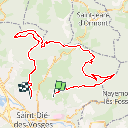
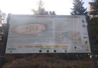
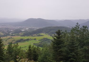
Randonnée Marche de 18,4 km à découvrir à Grand Est, Vosges, Saint-Dié-des-Vosges. Cette randonnée est proposée par DanielROLLET.
Description
Départ et arrivées à la gare SNCF de Saint Dié.
Nancy 7h50 > Saint-Dié 8h53
Saint Dié 16h31 > Nancy 17h48
Bus L2 jusqu'à l'arrêt Paradis à 9h38 > 9h49
Bus L1 à l'arrêt Tuilerie 16h09 > 16h19 à la gare.
Localisation
Pays :
France
Région :
Grand Est
Département/Province :
Vosges
Commune :
Saint-Dié-des-Vosges
Localité :
Unknown
Départ:(Dec)
Départ:(UTM)
348854 ; 5351413 (32U) N.
Commentaires
Randonnées à proximité
![Randonnée V.T.T. Saint-Dié-des-Vosges - vtt la voivre La Bure 29-03-19 - Photo](https://media.geolcdn.com/t/375/260/651ec868-e046-448c-a37f-e725fa61f50d.jpg&format=jpg&maxdim=2)
![V.T.T. V.T.T.](https://static1.geolcdn.com/sitytour/trail-icons/202.png)
vtt la voivre La Bure 29-03-19
V.T.T.
Difficile
(2)
Saint-Dié-des-Vosges,
Grand Est,
Vosges,
France
![](/images/other/stat-length.png)
20 km | 28 km-effort
2h 48min
![](https://static1.geolcdn.com/siteimages/upload/files/16400158638029165_repeat_loop_refresh_sync_direction_icon.png)
Oui
![Randonnée Marche Saint-Michel-sur-Meurthe - massif de la madeleine - Photo](https://media.geolcdn.com/t/375/260/ext.jpg?maxdim=2&url=https%3A%2F%2Fservices.sitytrail.com%2FGeolivesWS%2FDownloadMedia.ashx%3FTrailID%3D1148232%26Media%3D20190421153638.jpg)
![Marche Marche](https://static1.geolcdn.com/sitytour/trail-icons/101.png)
massif de la madeleine
Marche
Moyen
(1)
Saint-Michel-sur-Meurthe,
Grand Est,
Vosges,
France
![](/images/other/stat-length.png)
14,7 km | 22 km-effort
4h 10min
![](https://static1.geolcdn.com/siteimages/upload/files/16400158638029165_repeat_loop_refresh_sync_direction_icon.png)
Oui
![Randonnée A pied Taintrux - GR de Pays de Déodatie - Photo](https://media.geolcdn.com/t/375/260/8c9d86c2-6a8a-421f-b627-7552051e9313.jpeg&format=jpg&maxdim=2)
![A pied A pied](https://static1.geolcdn.com/sitytour/trail-icons/100.png)
GR de Pays de Déodatie
A pied
Facile
Taintrux,
Grand Est,
Vosges,
France
![](/images/other/stat-length.png)
7,9 km | 12,5 km-effort
2h 49min
![](https://static1.geolcdn.com/siteimages/upload/files/16400158638029165_repeat_loop_refresh_sync_direction_icon.png)
Non
![Randonnée Marche Saint-Dié-des-Vosges - 2019-03-07 Marche Montée des Schlitteurs - Photo](https://media.geolcdn.com/t/375/260/b6c7faad-e93b-4a65-8c3b-cd428aea5e79.jpg&format=jpg&maxdim=2)
![Marche Marche](https://static1.geolcdn.com/sitytour/trail-icons/101.png)
2019-03-07 Marche Montée des Schlitteurs
Marche
Très facile
Saint-Dié-des-Vosges,
Grand Est,
Vosges,
France
![](/images/other/stat-length.png)
11,3 km | 19,6 km-effort
4h 35min
![](https://static1.geolcdn.com/siteimages/upload/files/16400158638029165_repeat_loop_refresh_sync_direction_icon.png)
Oui
![Randonnée Marche Taintrux - 2024-05-10 Marche Taintrux - Photo](https://media.geolcdn.com/t/375/260/9fe93acc-f8ea-40c3-b435-6f108f3a2d6d.jpg&format=jpg&maxdim=2)
![Marche Marche](https://static1.geolcdn.com/sitytour/trail-icons/101.png)
2024-05-10 Marche Taintrux
Marche
Moyen
Taintrux,
Grand Est,
Vosges,
France
![](/images/other/stat-length.png)
18,8 km | 32 km-effort
7h 14min
![](https://static1.geolcdn.com/siteimages/upload/files/16400158638029165_repeat_loop_refresh_sync_direction_icon.png)
Non
![Randonnée Marche Saint-Dié-des-Vosges - Massif de l'Ormont et ses rochers remarquables - Photo](https://media.geolcdn.com/t/375/260/5bfc527b-060c-4d01-aae8-b360a5c8e4f1.jpg&format=jpg&maxdim=2)
![Marche Marche](https://static1.geolcdn.com/sitytour/trail-icons/101.png)
Massif de l'Ormont et ses rochers remarquables
Marche
Très difficile
Saint-Dié-des-Vosges,
Grand Est,
Vosges,
France
![](/images/other/stat-length.png)
15,9 km | 25 km-effort
5h 38min
![](https://static1.geolcdn.com/siteimages/upload/files/16400158638029165_repeat_loop_refresh_sync_direction_icon.png)
Oui
![Randonnée Marche Saint-Dié-des-Vosges - 2021-10-08 Marche St Die Metzeral Jour 1 - Photo](https://media.geolcdn.com/t/375/260/e22b097e-6393-4be9-8a81-a85993f41b61.jpg&format=jpg&maxdim=2)
![Marche Marche](https://static1.geolcdn.com/sitytour/trail-icons/101.png)
2021-10-08 Marche St Die Metzeral Jour 1
Marche
Très difficile
Saint-Dié-des-Vosges,
Grand Est,
Vosges,
France
![](/images/other/stat-length.png)
26 km | 39 km-effort
7h 40min
![](https://static1.geolcdn.com/siteimages/upload/files/16400158638029165_repeat_loop_refresh_sync_direction_icon.png)
Non
![Randonnée Marche Saint-Dié-des-Vosges - Balade autour du Col de la Crenée - Photo](https://media.geolcdn.com/t/375/260/b78964f0-a68e-41e2-996e-5f3508692050.jpg&format=jpg&maxdim=2)
![Marche Marche](https://static1.geolcdn.com/sitytour/trail-icons/101.png)
Balade autour du Col de la Crenée
Marche
Facile
(1)
Saint-Dié-des-Vosges,
Grand Est,
Vosges,
France
![](/images/other/stat-length.png)
11,4 km | 17 km-effort
3h 48min
![](https://static1.geolcdn.com/siteimages/upload/files/16400158638029165_repeat_loop_refresh_sync_direction_icon.png)
Oui
![Randonnée Marche Saint-Dié-des-Vosges - Marche 15km Ormont 07-05-21 - Photo](https://media.geolcdn.com/t/375/260/11be56d0-7566-44e9-9c14-ad469692e3f9.jpg&format=jpg&maxdim=2)
![Marche Marche](https://static1.geolcdn.com/sitytour/trail-icons/101.png)
Marche 15km Ormont 07-05-21
Marche
Très difficile
Saint-Dié-des-Vosges,
Grand Est,
Vosges,
France
![](/images/other/stat-length.png)
13,5 km | 25 km-effort
4h 3min
![](https://static1.geolcdn.com/siteimages/upload/files/16400158638029165_repeat_loop_refresh_sync_direction_icon.png)
Oui