![](/images/other/stat-length.png)
![Randonnée Marche Banyalbufar - RM-Banyalbufar-Port des Canonge - Photo](https://media.geolcdn.com/t/1900/400/ext.pjpeg?maxdim=2&url=https%3A%2F%2Fstatic1.geolcdn.com%2Fsiteimages%2Fupload%2Ffiles%2F1553511878bg_sport_marche.png)
RM-Banyalbufar-Port des Canonge
Polo-31
Utilisateur
![Longueur](/images/other/stat-length.png)
Longueur
5,3 km
![Altitude max](https://static1.geolcdn.com/siteimages/upload/files/1508320355ic_sort_altitude_max_24dp.png)
Altitude max
190 m
![Dénivelé positif](https://static1.geolcdn.com/siteimages/upload/files/1508320355ic_sort_den_pos_24dp.png)
Dénivelé positif
208 m
![Km-Effort](/images/other/stat-length.png)
Km-Effort
8,3 km
![Altitude min](https://static1.geolcdn.com/siteimages/upload/files/1508320355ic_sort_altitude_min_24dp.png)
Altitude min
2 m
![Dénivelé négatif](https://static1.geolcdn.com/siteimages/upload/files/1508320355ic_sort_den_neg_24dp.png)
Dénivelé négatif
269 m
![Boucle](https://static1.geolcdn.com/siteimages/upload/files/16400158638029165_repeat_loop_refresh_sync_direction_icon.png)
Boucle
Non
Date de création :
2016-04-30 00:00:00.0
Dernière modification :
2016-04-30 00:00:00.0
![Marche](https://static1.geolcdn.com/sitytour/trail-icons/101.png)
1h49
Difficulté : Facile
![Scannez ce code QR pour ouvrir la randonnée dans l'application SityTrail](https://capi.geolives.com/qq0zvz2zws4bq2lad0pu/sitytour/trails/561165/qr.png?size=200)
Application GPS de randonnée GRATUITE
À propos
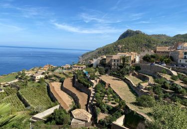
Randonnée Marche de 5,3 km à découvrir à Îles Baléares, Inconnu, Banyalbufar. Cette randonnée est proposée par Polo-31.
Description
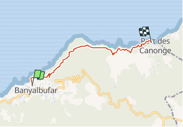
RANDO MALLORCA : de Banyalbufar à Port des Canonge via le cami de Baix. A faire en A/R au départ de Banyalbufar ou de Port des Canonge (Descente en voiture difficile).
Localisation
Pays :
Espagne
Région :
Îles Baléares
Département/Province :
Inconnu
Commune :
Banyalbufar
Localité :
Unknown
Départ:(Dec)
Départ:(UTM)
458305 ; 4393306 (31S) N.
Commentaires
Randonnées à proximité
![Randonnée A pied Banyalbufar - Camí de sa Volta des General - Photo](https://media.geolcdn.com/t/375/260/8b28ca13-a16d-4887-a8d7-ae1af2458aa6.jpeg&format=jpg&maxdim=2)
![A pied A pied](https://static1.geolcdn.com/sitytour/trail-icons/100.png)
Camí de sa Volta des General
A pied
Facile
Banyalbufar,
Îles Baléares,
Inconnu,
Espagne
![](/images/other/stat-length.png)
4,5 km | 6,2 km-effort
1h 24min
![](https://static1.geolcdn.com/siteimages/upload/files/16400158638029165_repeat_loop_refresh_sync_direction_icon.png)
Non
![Randonnée A pied Banyalbufar - Camí des Pescadors - Photo](https://media.geolcdn.com/t/375/260/ede1eb3a-e761-43e6-b1d2-8ff02557f9d3.jpeg&format=jpg&maxdim=2)
![A pied A pied](https://static1.geolcdn.com/sitytour/trail-icons/100.png)
Camí des Pescadors
A pied
Facile
Banyalbufar,
Îles Baléares,
Inconnu,
Espagne
![](/images/other/stat-length.png)
5,3 km | 7,1 km-effort
1h 37min
![](https://static1.geolcdn.com/siteimages/upload/files/16400158638029165_repeat_loop_refresh_sync_direction_icon.png)
Non
![Randonnée Marche Estellencs - GR221 # Estellencs - Banyalbufar - Esporles - Photo](https://media.geolcdn.com/t/375/260/a5f3f2da-c0dd-4223-9da3-4cd5b790682e.jpg&format=jpg&maxdim=2)
![Marche Marche](https://static1.geolcdn.com/sitytour/trail-icons/101.png)
GR221 # Estellencs - Banyalbufar - Esporles
Marche
Moyen
(2)
Estellencs,
Îles Baléares,
Inconnu,
Espagne
![](/images/other/stat-length.png)
16,1 km | 25 km-effort
4h 38min
![](https://static1.geolcdn.com/siteimages/upload/files/16400158638029165_repeat_loop_refresh_sync_direction_icon.png)
Non
![Randonnée Marche Banyalbufar - ggggggt. - Photo](https://media.geolcdn.com/t/375/260/ext.jpg?maxdim=2&url=https%3A%2F%2Fstatic1.geolcdn.com%2Fsiteimages%2Fupload%2Ffiles%2F1553511878bg_sport_marche.png)
![Marche Marche](https://static1.geolcdn.com/sitytour/trail-icons/101.png)
![Randonnée Marche Banyalbufar - Mallorca- Port d'es Canonge 13-10-2017 - Photo](https://media.geolcdn.com/t/375/260/ext.jpg?maxdim=2&url=https%3A%2F%2Fstatic1.geolcdn.com%2Fsiteimages%2Fupload%2Ffiles%2F1553511878bg_sport_marche.png)
![Marche Marche](https://static1.geolcdn.com/sitytour/trail-icons/101.png)
Mallorca- Port d'es Canonge 13-10-2017
Marche
Facile
Banyalbufar,
Îles Baléares,
Inconnu,
Espagne
![](/images/other/stat-length.png)
8,7 km | 13,4 km-effort
2h 9min
![](https://static1.geolcdn.com/siteimages/upload/files/16400158638029165_repeat_loop_refresh_sync_direction_icon.png)
Oui
![Randonnée Marche Banyalbufar - 20221023majo - Photo](https://media.geolcdn.com/t/375/260/ext.jpg?maxdim=2&url=https%3A%2F%2Fstatic1.geolcdn.com%2Fsiteimages%2Fupload%2Ffiles%2F1553511878bg_sport_marche.png)
![Marche Marche](https://static1.geolcdn.com/sitytour/trail-icons/101.png)
20221023majo
Marche
Difficile
Banyalbufar,
Îles Baléares,
Inconnu,
Espagne
![](/images/other/stat-length.png)
9,3 km | 13,6 km-effort
4h 49min
![](https://static1.geolcdn.com/siteimages/upload/files/16400158638029165_repeat_loop_refresh_sync_direction_icon.png)
Oui
![Randonnée Marche Banyalbufar - Du port d'Es canonge à Esporlès - Photo](https://media.geolcdn.com/t/375/260/ext.jpg?maxdim=2&url=https%3A%2F%2Fstatic1.geolcdn.com%2Fsiteimages%2Fupload%2Ffiles%2F1553511878bg_sport_marche.png)
![Marche Marche](https://static1.geolcdn.com/sitytour/trail-icons/101.png)
Du port d'Es canonge à Esporlès
Marche
Moyen
Banyalbufar,
Îles Baléares,
Inconnu,
Espagne
![](/images/other/stat-length.png)
7,8 km | 12,6 km-effort
1h 42min
![](https://static1.geolcdn.com/siteimages/upload/files/16400158638029165_repeat_loop_refresh_sync_direction_icon.png)
Non