![](/images/other/stat-length.png)
![Randonnée Marche Nahuja - boucle de Nahuja - Photo](https://media.geolcdn.com/t/1900/400/ext.pjpeg?maxdim=2&url=https%3A%2F%2Fservices.sitytrail.com%2FGeolivesWS%2FDownloadMedia.ashx%3FTrailID%3D558835%26Media%3D20160425135530.jpg)
boucle de Nahuja
crijack
Utilisateur
![Longueur](/images/other/stat-length.png)
Longueur
11,8 km
![Altitude max](https://static1.geolcdn.com/siteimages/upload/files/1508320355ic_sort_altitude_max_24dp.png)
Altitude max
1744 m
![Dénivelé positif](https://static1.geolcdn.com/siteimages/upload/files/1508320355ic_sort_den_pos_24dp.png)
Dénivelé positif
480 m
![Km-Effort](/images/other/stat-length.png)
Km-Effort
18,2 km
![Altitude min](https://static1.geolcdn.com/siteimages/upload/files/1508320355ic_sort_altitude_min_24dp.png)
Altitude min
1266 m
![Dénivelé négatif](https://static1.geolcdn.com/siteimages/upload/files/1508320355ic_sort_den_neg_24dp.png)
Dénivelé négatif
484 m
![Boucle](https://static1.geolcdn.com/siteimages/upload/files/16400158638029165_repeat_loop_refresh_sync_direction_icon.png)
Boucle
Oui
Date de création :
2016-04-25 00:00:00.0
Dernière modification :
2016-04-25 00:00:00.0
![Marche](https://static1.geolcdn.com/sitytour/trail-icons/101.png)
2h44
Difficulté : Moyen
![Scannez ce code QR pour ouvrir la randonnée dans l'application SityTrail](https://capi.geolives.com/qq0zvz2zws4bq2lad0pu/sitytour/trails/558835/qr.png?size=200)
Application GPS de randonnée GRATUITE
À propos
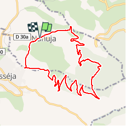
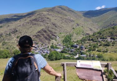
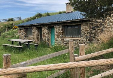
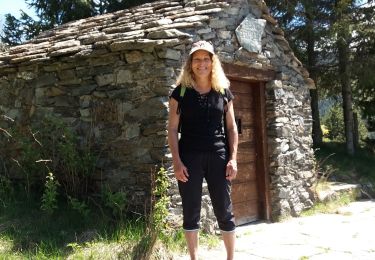
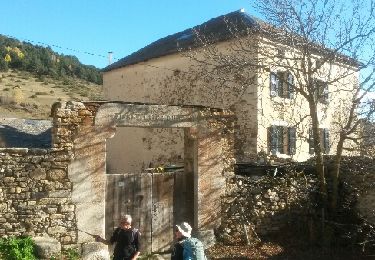
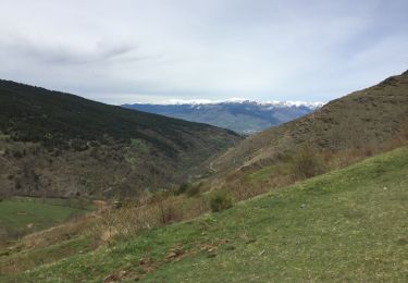
Randonnée Marche de 11,8 km à découvrir à Occitanie, Pyrénées-Orientales, Nahuja. Cette randonnée est proposée par crijack.
Description
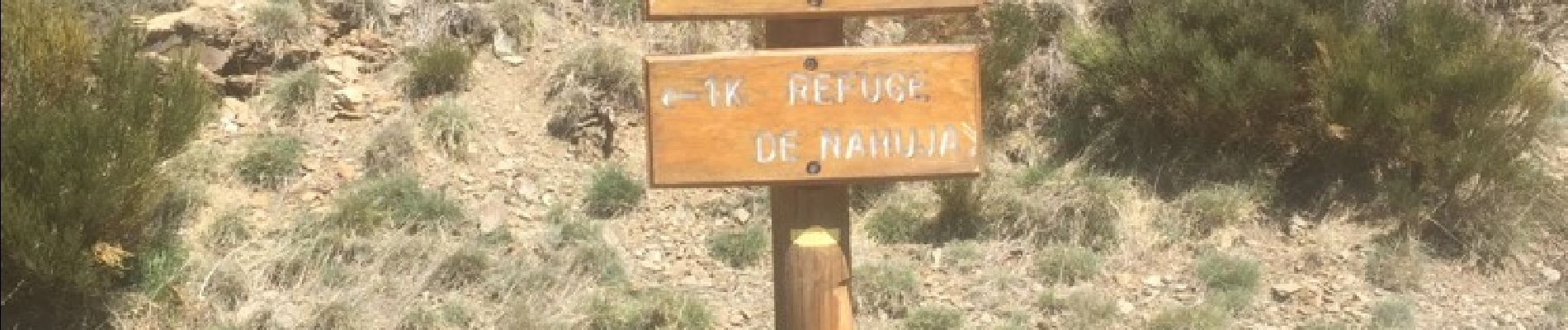
Chemin de Nahuja au refuge et retour avec une vue splendide tout au long de la descente qui se termine par un petit raccourci
Localisation
Pays :
France
Région :
Occitanie
Département/Province :
Pyrénées-Orientales
Commune :
Nahuja
Localité :
Unknown
Départ:(Dec)
Départ:(UTM)
417205 ; 4697434 (31T) N.
Commentaires
Randonnées à proximité
![Randonnée Marche Ur - de Ur vers La Chapelle de Belloc - Photo](https://media.geolcdn.com/t/375/260/ext.jpg?maxdim=2&url=https%3A%2F%2Fservices.sitytrail.com%2FGeolivesWS%2FDownloadMedia.ashx%3FTrailID%3D661447%26Media%3D20161117163202.jpg)
![Marche Marche](https://static1.geolcdn.com/sitytour/trail-icons/101.png)
de Ur vers La Chapelle de Belloc
Marche
Facile
(1)
Ur,
Occitanie,
Pyrénées-Orientales,
France
![](/images/other/stat-length.png)
20 km | 28 km-effort
7h 14min
![](https://static1.geolcdn.com/siteimages/upload/files/16400158638029165_repeat_loop_refresh_sync_direction_icon.png)
Oui
![Randonnée sport Saillagouse - 20240623 Saillagouse -Err - Photo](https://media.geolcdn.com/t/375/260/d03d78d9-6da5-4117-90c7-02839286e5c6.jpg&format=jpg&maxdim=2)
20240623 Saillagouse -Err
sport
Très facile
Saillagouse,
Occitanie,
Pyrénées-Orientales,
France
![](/images/other/stat-length.png)
11,9 km | 15,5 km-effort
Inconnu
![](https://static1.geolcdn.com/siteimages/upload/files/16400158638029165_repeat_loop_refresh_sync_direction_icon.png)
Oui
![Randonnée Marche Valcebollère - Chapelle San Bernabéu - Photo](https://media.geolcdn.com/t/375/260/9aec05f5-c983-4353-80fa-609f342769b3.jpg&format=jpg&maxdim=2)
![Marche Marche](https://static1.geolcdn.com/sitytour/trail-icons/101.png)
Chapelle San Bernabéu
Marche
Facile
Valcebollère,
Occitanie,
Pyrénées-Orientales,
France
![](/images/other/stat-length.png)
5,4 km | 8,6 km-effort
1h 50min
![](https://static1.geolcdn.com/siteimages/upload/files/16400158638029165_repeat_loop_refresh_sync_direction_icon.png)
Non
![Randonnée Marche Estavar - 20220328 Estavar-Tartassonne(?) - Photo](https://media.geolcdn.com/t/375/260/d3a84297-78f4-4823-a8d6-7ab122d863c3.jpg&format=jpg&maxdim=2)
![Marche Marche](https://static1.geolcdn.com/sitytour/trail-icons/101.png)
20220328 Estavar-Tartassonne(?)
Marche
Moyen
Estavar,
Occitanie,
Pyrénées-Orientales,
France
![](/images/other/stat-length.png)
14,8 km | 22 km-effort
3h 16min
![](https://static1.geolcdn.com/siteimages/upload/files/16400158638029165_repeat_loop_refresh_sync_direction_icon.png)
Oui
![Randonnée Marche Saillagouse - 20210627 à partir de Saillagouse - Photo](https://media.geolcdn.com/t/375/260/5a9d5a7e-3810-4051-9ba7-f647620cb7e7.jpg&format=jpg&maxdim=2)
![Marche Marche](https://static1.geolcdn.com/sitytour/trail-icons/101.png)
20210627 à partir de Saillagouse
Marche
Moyen
(1)
Saillagouse,
Occitanie,
Pyrénées-Orientales,
France
![](/images/other/stat-length.png)
16,2 km | 26 km-effort
3h 47min
![](https://static1.geolcdn.com/siteimages/upload/files/16400158638029165_repeat_loop_refresh_sync_direction_icon.png)
Oui
![Randonnée Marche Valcebollère - la cami de sant bertheleu - Photo](https://media.geolcdn.com/t/375/260/bc57d595-92e3-4ec5-83cc-2b8866de7a20.jpg&format=jpg&maxdim=2)
![Marche Marche](https://static1.geolcdn.com/sitytour/trail-icons/101.png)
la cami de sant bertheleu
Marche
Très facile
Valcebollère,
Occitanie,
Pyrénées-Orientales,
France
![](/images/other/stat-length.png)
6,2 km | 9,7 km-effort
2h 25min
![](https://static1.geolcdn.com/siteimages/upload/files/16400158638029165_repeat_loop_refresh_sync_direction_icon.png)
Oui
![Randonnée Marche Ur - ur - Photo](https://media.geolcdn.com/t/375/260/ext.jpg?maxdim=2&url=https%3A%2F%2Fservices.sitytrail.com%2FGeolivesWS%2FDownloadMedia.ashx%3FTrailID%3D664005%26Media%3Dfix__20161117140353.jpg)
![Marche Marche](https://static1.geolcdn.com/sitytour/trail-icons/101.png)
![Randonnée Marche Valcebollère - Valcebollère chapelle Saint Barnabeu - Photo](https://media.geolcdn.com/t/375/260/ext.jpg?maxdim=2&url=https%3A%2F%2Fservices.sitytrail.com%2FGeolivesWS%2FDownloadMedia.ashx%3FTrailID%3D566810%26Media%3D20160510122127.jpg)
![Marche Marche](https://static1.geolcdn.com/sitytour/trail-icons/101.png)
Valcebollère chapelle Saint Barnabeu
Marche
Moyen
Valcebollère,
Occitanie,
Pyrénées-Orientales,
France
![](/images/other/stat-length.png)
11,3 km | 17,4 km-effort
3h 27min
![](https://static1.geolcdn.com/siteimages/upload/files/16400158638029165_repeat_loop_refresh_sync_direction_icon.png)
Oui
![Randonnée Marche Valcebollère - Valcebollère chapelle Saint Barnabeu - Photo](https://media.geolcdn.com/t/375/260/ext.jpg?maxdim=2&url=https%3A%2F%2Fservices.sitytrail.com%2FGeolivesWS%2FDownloadMedia.ashx%3FTrailID%3D566797%26Media%3D20160510122127.jpg)
![Marche Marche](https://static1.geolcdn.com/sitytour/trail-icons/101.png)
Valcebollère chapelle Saint Barnabeu
Marche
Moyen
Valcebollère,
Occitanie,
Pyrénées-Orientales,
France
![](/images/other/stat-length.png)
11,3 km | 17,4 km-effort
3h 27min
![](https://static1.geolcdn.com/siteimages/upload/files/16400158638029165_repeat_loop_refresh_sync_direction_icon.png)
Oui