![](/images/other/stat-length.png)
![Randonnée Marche Peillac - Peillac - Photo](https://media.geolcdn.com/t/1900/400/ext.pjpeg?maxdim=2&url=https%3A%2F%2Fservices.sitytrail.com%2FGeolivesWS%2FDownloadMedia.ashx%3FTrailID%3D558503%26Media%3Dca741228-3170-4a38-b84f-275e9a63d49c.jpg)
Peillac
neoroll44
Utilisateur
![Longueur](/images/other/stat-length.png)
Longueur
9 km
![Altitude max](https://static1.geolcdn.com/siteimages/upload/files/1508320355ic_sort_altitude_max_24dp.png)
Altitude max
65 m
![Dénivelé positif](https://static1.geolcdn.com/siteimages/upload/files/1508320355ic_sort_den_pos_24dp.png)
Dénivelé positif
143 m
![Km-Effort](/images/other/stat-length.png)
Km-Effort
10,9 km
![Altitude min](https://static1.geolcdn.com/siteimages/upload/files/1508320355ic_sort_altitude_min_24dp.png)
Altitude min
3 m
![Dénivelé négatif](https://static1.geolcdn.com/siteimages/upload/files/1508320355ic_sort_den_neg_24dp.png)
Dénivelé négatif
147 m
![Boucle](https://static1.geolcdn.com/siteimages/upload/files/16400158638029165_repeat_loop_refresh_sync_direction_icon.png)
Boucle
Oui
Date de création :
2016-04-24 00:00:00.0
Dernière modification :
2016-04-24 00:00:00.0
![Marche](https://static1.geolcdn.com/sitytour/trail-icons/101.png)
2h20
Difficulté : Moyen
![Scannez ce code QR pour ouvrir la randonnée dans l'application SityTrail](https://capi.geolives.com/qq0zvz2zws4bq2lad0pu/sitytour/trails/558503/qr.png?size=200)
Application GPS de randonnée GRATUITE
À propos
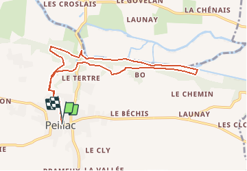
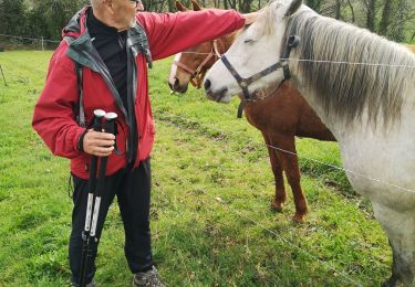
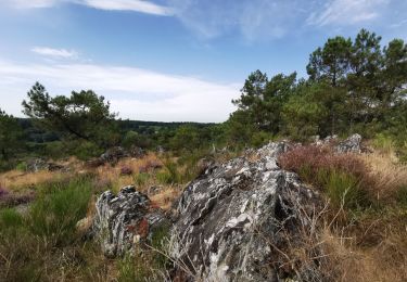
Randonnée Marche de 9 km à découvrir à Bretagne, Morbihan, Peillac. Cette randonnée est proposée par neoroll44.
Description
Echappez-vous le temps d’une balade par les sentiers ombragés pour rejoindre, depuis Peillac, le Pont d’Oust et le canal de Nantes à Brest puis sur le haut d’un coteau vous traverserez des villages traditionnels.
Localisation
Pays :
France
Région :
Bretagne
Département/Province :
Morbihan
Commune :
Peillac
Localité :
Unknown
Départ:(Dec)
Départ:(UTM)
558657 ; 5284753 (30T) N.
Commentaires
Randonnées à proximité
![Randonnée A pied Les Fougerêts - Circuit des Landes - Photo](https://media.geolcdn.com/t/375/260/33ff353e-b6ed-4246-9e2f-0764c82b7dd0.jpeg&format=jpg&maxdim=2)
![A pied A pied](https://static1.geolcdn.com/sitytour/trail-icons/100.png)
Circuit des Landes
A pied
Facile
Les Fougerêts,
Bretagne,
Morbihan,
France
![](/images/other/stat-length.png)
13,9 km | 16,6 km-effort
3h 46min
![](https://static1.geolcdn.com/siteimages/upload/files/16400158638029165_repeat_loop_refresh_sync_direction_icon.png)
Oui
![Randonnée Marche Les Fougerêts - Les Fougerêts - Photo](https://media.geolcdn.com/t/375/260/44aa5b7b-f4f4-4362-8f34-0cf8c323af37.jpg&format=jpg&maxdim=2)
![Marche Marche](https://static1.geolcdn.com/sitytour/trail-icons/101.png)
Les Fougerêts
Marche
Très facile
Les Fougerêts,
Bretagne,
Morbihan,
France
![](/images/other/stat-length.png)
13,9 km | 15,9 km-effort
4h 22min
![](https://static1.geolcdn.com/siteimages/upload/files/16400158638029165_repeat_loop_refresh_sync_direction_icon.png)
Oui
![Randonnée Marche Les Fougerêts - GR_347_AB_02_Fougerets_St-Laurent-Oust_20190324 - Photo](https://media.geolcdn.com/t/375/260/fc30711e-ce5d-4d10-a370-473bc49e3a48.jpg&format=jpg&maxdim=2)
![Marche Marche](https://static1.geolcdn.com/sitytour/trail-icons/101.png)
GR_347_AB_02_Fougerets_St-Laurent-Oust_20190324
Marche
Facile
Les Fougerêts,
Bretagne,
Morbihan,
France
![](/images/other/stat-length.png)
20 km | 24 km-effort
5h 20min
![](https://static1.geolcdn.com/siteimages/upload/files/16400158638029165_repeat_loop_refresh_sync_direction_icon.png)
Non
![Randonnée Marche Peillac - 213- rando de Peillac du côté de la Chapelle Saint Julien - Photo](https://media.geolcdn.com/t/375/260/0ea1a68c-2b28-4a76-b661-2db730755661.jpg&format=jpg&maxdim=2)
![Marche Marche](https://static1.geolcdn.com/sitytour/trail-icons/101.png)
213- rando de Peillac du côté de la Chapelle Saint Julien
Marche
Facile
Peillac,
Bretagne,
Morbihan,
France
![](/images/other/stat-length.png)
15,4 km | 17,8 km-effort
3h 25min
![](https://static1.geolcdn.com/siteimages/upload/files/16400158638029165_repeat_loop_refresh_sync_direction_icon.png)
Oui
![Randonnée Marche Saint-Gravé - Vers les grées et le mur interminable. - Photo](https://media.geolcdn.com/t/375/260/816b86f2-af85-435f-acfa-84734df68fff.jpg&format=jpg&maxdim=2)
![Marche Marche](https://static1.geolcdn.com/sitytour/trail-icons/101.png)
Vers les grées et le mur interminable.
Marche
Très facile
Saint-Gravé,
Bretagne,
Morbihan,
France
![](/images/other/stat-length.png)
9,6 km | 11,9 km-effort
2h 37min
![](https://static1.geolcdn.com/siteimages/upload/files/16400158638029165_repeat_loop_refresh_sync_direction_icon.png)
Oui
![Randonnée Marche Les Fougerêts - 13.09.2019 - DES Fougerets à Glénac.Corrigé - Photo](https://media.geolcdn.com/t/375/260/3f11c453-402e-4421-a669-65de6b1e3baf.jpg&format=jpg&maxdim=2)
![Marche Marche](https://static1.geolcdn.com/sitytour/trail-icons/101.png)
13.09.2019 - DES Fougerets à Glénac.Corrigé
Marche
Difficile
Les Fougerêts,
Bretagne,
Morbihan,
France
![](/images/other/stat-length.png)
29 km | 34 km-effort
8h 33min
![](https://static1.geolcdn.com/siteimages/upload/files/16400158638029165_repeat_loop_refresh_sync_direction_icon.png)
Oui
![Randonnée Marche Les Fougerêts - 13.04.2019 corrigé - La Gacilly sud à Glénac - Photo](https://media.geolcdn.com/t/375/260/ext.jpg?maxdim=2&url=https%3A%2F%2Fservices.sitytrail.com%2FGeolivesWS%2FDownloadMedia.ashx%3FTrailID%3D1135060%26Media%3D20190413084815.jpg)
![Marche Marche](https://static1.geolcdn.com/sitytour/trail-icons/101.png)
13.04.2019 corrigé - La Gacilly sud à Glénac
Marche
Moyen
Les Fougerêts,
Bretagne,
Morbihan,
France
![](/images/other/stat-length.png)
28 km | 34 km-effort
7h 26min
![](https://static1.geolcdn.com/siteimages/upload/files/16400158638029165_repeat_loop_refresh_sync_direction_icon.png)
Oui
![Randonnée Marche La Gacilly - 13.04.2019 - La Gacilly sud à Glénac - Photo](https://media.geolcdn.com/t/375/260/ext.jpg?maxdim=2&url=https%3A%2F%2Fservices.sitytrail.com%2FGeolivesWS%2FDownloadMedia.ashx%3FTrailID%3D1134542%26Media%3D20190413081524.jpg)
![Marche Marche](https://static1.geolcdn.com/sitytour/trail-icons/101.png)
13.04.2019 - La Gacilly sud à Glénac
Marche
Moyen
La Gacilly,
Bretagne,
Morbihan,
France
![](/images/other/stat-length.png)
31 km | 38 km-effort
8h 28min
![](https://static1.geolcdn.com/siteimages/upload/files/16400158638029165_repeat_loop_refresh_sync_direction_icon.png)
Oui
![Randonnée Marche Les Fougerêts - Circuit des Landes - Les Fougerêts - Photo](https://media.geolcdn.com/t/375/260/ext.jpg?maxdim=2&url=https%3A%2F%2Fservices.sitytrail.com%2FGeolivesWS%2FDownloadMedia.ashx%3FTrailID%3D111725%26Media%3D8073_2.jpg)
![Marche Marche](https://static1.geolcdn.com/sitytour/trail-icons/101.png)
Circuit des Landes - Les Fougerêts
Marche
Difficile
Les Fougerêts,
Bretagne,
Morbihan,
France
![](/images/other/stat-length.png)
13,8 km | 16,4 km-effort
3h 25min
![](https://static1.geolcdn.com/siteimages/upload/files/16400158638029165_repeat_loop_refresh_sync_direction_icon.png)
Oui