![](/images/other/stat-length.png)
![Randonnée Marche Louvigné-du-Désert - Louvigné_Vergers - Photo](https://media.geolcdn.com/t/1900/400/ext.pjpeg?maxdim=2&url=https%3A%2F%2Fstatic1.geolcdn.com%2Fsiteimages%2Fupload%2Ffiles%2F1553511878bg_sport_marche.png)
Louvigné_Vergers
neoroll44
Utilisateur
![Longueur](/images/other/stat-length.png)
![Altitude max](https://static1.geolcdn.com/siteimages/upload/files/1508320355ic_sort_altitude_max_24dp.png)
![Dénivelé positif](https://static1.geolcdn.com/siteimages/upload/files/1508320355ic_sort_den_pos_24dp.png)
![Km-Effort](/images/other/stat-length.png)
![Altitude min](https://static1.geolcdn.com/siteimages/upload/files/1508320355ic_sort_altitude_min_24dp.png)
![Dénivelé négatif](https://static1.geolcdn.com/siteimages/upload/files/1508320355ic_sort_den_neg_24dp.png)
![Boucle](https://static1.geolcdn.com/siteimages/upload/files/16400158638029165_repeat_loop_refresh_sync_direction_icon.png)
![Marche](https://static1.geolcdn.com/sitytour/trail-icons/101.png)
2h10
Difficulté : Facile
![Scannez ce code QR pour ouvrir la randonnée dans l'application SityTrail](https://capi.geolives.com/qq0zvz2zws4bq2lad0pu/sitytour/trails/558489/qr.png?size=200)
Application GPS de randonnée GRATUITE
À propos
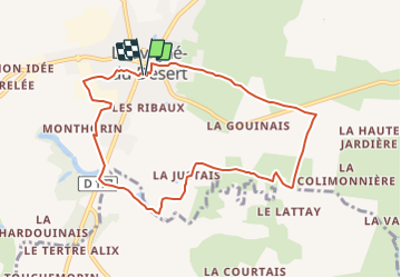
Randonnée Marche de 8,4 km à découvrir à Bretagne, Ille-et-Vilaine, Louvigné-du-Désert. Cette randonnée est proposée par neoroll44.
Description
Circuit des vergers (bleu).
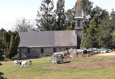
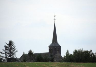
Départ Place Bochin derrière la Mairie. Prendre la rue Auvraie et tourner à droite, passer devant la Chapelle Saint-Jean. Descendre la rue
Saint-Martin et continuer tout droit.
Passé le village de La Cormerie, prendre un chemin de terre vers la droite. À La Croix Ferrand continuer tout droit sur 300 m avant de prendre vers la droite sur une bande enherbée le long de la route jusqu’au village du Lattay.
Au carrefour du Lattay prendre à droite, puis après le village, rentrer dans un chemin de terre sur la gauche. Traverser Les Champs et La Justais, prendre un chemin de terre traversant les vergers jusqu’à la
carrière de Godard.
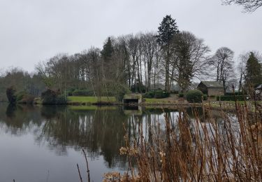
Au niveau de la carrière prendre une petite route à droite, longer le plan d’eau puis déboucher sur la route départementale. Longer
cette route à droite pendant 100 m puis traverser avant un pont pour rentrer dans le champ en face, entre une clôture et la dernière
rangée d’une plantation d’arbres. Au bout de cette plantation prendre à droite et après le pont, à gauche, contourner un lotissement.
Au bout, au niveau d’un transformateur, prendre à gauche 2 fois puis contourner les bâtiments de la Générale du Granit.
Tourner vers la droite, longer un champ et le terrain de foot. Au parking, continuer à travers
l’espace vert puis prendre un passage à droite et rejoindre la Mairie.
Localisation
Commentaires
Randonnées à proximité
![Randonnée A pied Monthault - Paysages et couleurs - Photo](https://media.geolcdn.com/t/375/260/c798034c-7fdc-45d8-a884-df843ba3721e.jpeg&format=jpg&maxdim=2)
![A pied A pied](https://static1.geolcdn.com/sitytour/trail-icons/100.png)
A pied
![](/images/other/stat-length.png)
![](https://static1.geolcdn.com/siteimages/upload/files/16400158638029165_repeat_loop_refresh_sync_direction_icon.png)
![Randonnée Marche Pontmain - Pontmain - Photo](https://media.geolcdn.com/t/375/260/90262822-4f6f-4ff3-b974-3007b0fde0bd.jpg&format=jpg&maxdim=2)
![Marche Marche](https://static1.geolcdn.com/sitytour/trail-icons/101.png)
Marche
![](/images/other/stat-length.png)
![](https://static1.geolcdn.com/siteimages/upload/files/16400158638029165_repeat_loop_refresh_sync_direction_icon.png)
![Randonnée Marche Louvigné-du-Désert - Balade Saint-Guillaume - Louvigné du Désert - Photo](https://media.geolcdn.com/t/375/260/ext.jpg?maxdim=2&url=https%3A%2F%2Fservices.sitytrail.com%2FGeolivesWS%2FDownloadMedia.ashx%3FTrailID%3D317807%26Media%3D17138_3.jpg)
![Marche Marche](https://static1.geolcdn.com/sitytour/trail-icons/101.png)
Marche
![](/images/other/stat-length.png)
![](https://static1.geolcdn.com/siteimages/upload/files/16400158638029165_repeat_loop_refresh_sync_direction_icon.png)
![Randonnée Marche Mellé - Sentier Pierre & Nature - Mellé - Photo](https://media.geolcdn.com/t/375/260/ext.jpg?maxdim=2&url=https%3A%2F%2Fservices.sitytrail.com%2FGeolivesWS%2FDownloadMedia.ashx%3FTrailID%3D317764%26Media%3D17076_6.jpg)
![Marche Marche](https://static1.geolcdn.com/sitytour/trail-icons/101.png)
Marche
![](/images/other/stat-length.png)
![](https://static1.geolcdn.com/siteimages/upload/files/16400158638029165_repeat_loop_refresh_sync_direction_icon.png)
![Randonnée Marche nordique Louvigné-du-Désert - louvigné du desert - Photo](https://media.geolcdn.com/t/375/260/c0f0f5f5-327e-430a-806e-47e7180dff3e.jpg&format=jpg&maxdim=2)
![Marche nordique Marche nordique](https://static1.geolcdn.com/sitytour/trail-icons/102.png)
Marche nordique
![](/images/other/stat-length.png)
![](https://static1.geolcdn.com/siteimages/upload/files/16400158638029165_repeat_loop_refresh_sync_direction_icon.png)
![Randonnée Marche La Bazouge-du-Désert - La Bazouge_Epinay - Photo](https://media.geolcdn.com/t/375/260/ext.jpg?maxdim=2&url=https%3A%2F%2Fservices.sitytrail.com%2FGeolivesWS%2FDownloadMedia.ashx%3FTrailID%3D557504%26Media%3D847d43f0-82a6-4fba-b64f-67e6d0bf5f48.jpg)
![Marche Marche](https://static1.geolcdn.com/sitytour/trail-icons/101.png)
Marche
![](/images/other/stat-length.png)
![](https://static1.geolcdn.com/siteimages/upload/files/16400158638029165_repeat_loop_refresh_sync_direction_icon.png)
![Randonnée Marche Louvigné-du-Désert - La Morinais 13 kms - Photo](https://media.geolcdn.com/t/375/260/ext.jpg?maxdim=2&url=https%3A%2F%2Fstatic1.geolcdn.com%2Fsiteimages%2Fupload%2Ffiles%2F1553511878bg_sport_marche.png)
![Marche Marche](https://static1.geolcdn.com/sitytour/trail-icons/101.png)
Marche
![](/images/other/stat-length.png)
![](https://static1.geolcdn.com/siteimages/upload/files/16400158638029165_repeat_loop_refresh_sync_direction_icon.png)
![Randonnée Marche Louvigné-du-Désert - Pierrelée - Photo](https://media.geolcdn.com/t/375/260/ext.jpg?maxdim=2&url=https%3A%2F%2Fstatic1.geolcdn.com%2Fsiteimages%2Fupload%2Ffiles%2F1553511878bg_sport_marche.png)
![Marche Marche](https://static1.geolcdn.com/sitytour/trail-icons/101.png)
Marche
![](/images/other/stat-length.png)
![](https://static1.geolcdn.com/siteimages/upload/files/16400158638029165_repeat_loop_refresh_sync_direction_icon.png)
![Randonnée Autre activité Louvigné-du-Désert - Circuit St Guillaume Louvigne´ du De´sert VR 10,4 km - Photo](https://media.geolcdn.com/t/375/260/ext.jpg?maxdim=2&url=https%3A%2F%2Fstatic1.geolcdn.com%2Fsiteimages%2Fupload%2Ffiles%2F1545311037marcheuse_200dpi.jpg)
![Autre activité Autre activité](https://static1.geolcdn.com/sitytour/trail-icons/900.png)
Autre activité
![](/images/other/stat-length.png)
![](https://static1.geolcdn.com/siteimages/upload/files/16400158638029165_repeat_loop_refresh_sync_direction_icon.png)