![](/images/other/stat-length.png)
![Randonnée Marche Rösrath - Rösrath Athénée 5,5 km - Photo](https://media.geolcdn.com/t/1900/400/ext.pjpeg?maxdim=2&url=https%3A%2F%2Fstatic1.geolcdn.com%2Fsiteimages%2Fupload%2Ffiles%2F1553511878bg_sport_marche.png)
Rösrath Athénée 5,5 km
lucspa
Utilisateur
![Longueur](/images/other/stat-length.png)
Longueur
5,5 km
![Altitude max](https://static1.geolcdn.com/siteimages/upload/files/1508320355ic_sort_altitude_max_24dp.png)
Altitude max
139 m
![Dénivelé positif](https://static1.geolcdn.com/siteimages/upload/files/1508320355ic_sort_den_pos_24dp.png)
Dénivelé positif
91 m
![Km-Effort](/images/other/stat-length.png)
Km-Effort
6,7 km
![Altitude min](https://static1.geolcdn.com/siteimages/upload/files/1508320355ic_sort_altitude_min_24dp.png)
Altitude min
76 m
![Dénivelé négatif](https://static1.geolcdn.com/siteimages/upload/files/1508320355ic_sort_den_neg_24dp.png)
Dénivelé négatif
91 m
![Boucle](https://static1.geolcdn.com/siteimages/upload/files/16400158638029165_repeat_loop_refresh_sync_direction_icon.png)
Boucle
Oui
Date de création :
2016-04-23 00:00:00.0
Dernière modification :
2020-07-27 08:45:55.662
![Marche](https://static1.geolcdn.com/sitytour/trail-icons/101.png)
1h27
Difficulté : Moyen
![Scannez ce code QR pour ouvrir la randonnée dans l'application SityTrail](https://capi.geolives.com/qq0zvz2zws4bq2lad0pu/sitytour/trails/557708/qr.png?size=200)
Application GPS de randonnée GRATUITE
À propos
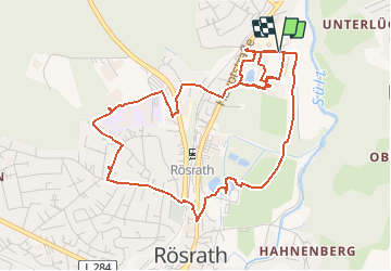
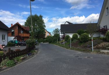
Randonnée Marche de 5,5 km à découvrir à Rhénanie-du-Nord-Westphalie, Rheinisch-Bergischer Kreis, Rösrath. Cette randonnée est proposée par lucspa.
Description
Petit circuit souvenir, l'A.R.R.(Athénéé Royal de Rösrath), la Claudiusstrasse, la Friedenstrasse, l'école primaire, ...
Localisation
Pays :
Allemagne
Région :
Rhénanie-du-Nord-Westphalie
Département/Province :
Rheinisch-Bergischer Kreis
Commune :
Rösrath
Localité :
Unknown
Départ:(Dec)
Départ:(UTM)
372712 ; 5640988 (32U) N.
Commentaires
Randonnées à proximité
![Randonnée A pied Lohmar - 18 Bauernhofweg - Photo](https://media.geolcdn.com/t/375/260/771a7b7d-5220-4a2a-b056-9251c7baf4c4.jpeg&format=jpg&maxdim=2)
![A pied A pied](https://static1.geolcdn.com/sitytour/trail-icons/100.png)
18 Bauernhofweg
A pied
Facile
Lohmar,
Rhénanie-du-Nord-Westphalie,
Rhein-Sieg-Kreis,
Allemagne
![](/images/other/stat-length.png)
12,5 km | 16,3 km-effort
3h 42min
![](https://static1.geolcdn.com/siteimages/upload/files/16400158638029165_repeat_loop_refresh_sync_direction_icon.png)
Oui
![Randonnée A pied Rösrath - Steinenbrück Rundweg A1 - Photo](https://media.geolcdn.com/t/375/260/f9384976-73ea-43d1-881f-62b07725c51f.jpeg&format=jpg&maxdim=2)
![A pied A pied](https://static1.geolcdn.com/sitytour/trail-icons/100.png)
Steinenbrück Rundweg A1
A pied
Facile
Rösrath,
Rhénanie-du-Nord-Westphalie,
Rheinisch-Bergischer Kreis,
Allemagne
![](/images/other/stat-length.png)
7,7 km | 10,4 km-effort
2h 22min
![](https://static1.geolcdn.com/siteimages/upload/files/16400158638029165_repeat_loop_refresh_sync_direction_icon.png)
Oui
![Randonnée A pied Bergisch Gladbach - BASt Rundweg A2 - Photo](https://media.geolcdn.com/t/375/260/c81d1256-cff1-40ad-9978-d43cbbb8cc9c.jpeg&format=jpg&maxdim=2)
![A pied A pied](https://static1.geolcdn.com/sitytour/trail-icons/100.png)
BASt Rundweg A2
A pied
Facile
Bergisch Gladbach,
Rhénanie-du-Nord-Westphalie,
Rheinisch-Bergischer Kreis,
Allemagne
![](/images/other/stat-length.png)
5,9 km | 6,9 km-effort
1h 34min
![](https://static1.geolcdn.com/siteimages/upload/files/16400158638029165_repeat_loop_refresh_sync_direction_icon.png)
Non
![Randonnée A pied Overath - Heiligenhaus Rundweg A3 - Photo](https://media.geolcdn.com/t/375/260/719b5283-a20c-4b41-9412-7ced6533fa5d.jpeg&format=jpg&maxdim=2)
![A pied A pied](https://static1.geolcdn.com/sitytour/trail-icons/100.png)
Heiligenhaus Rundweg A3
A pied
Facile
Overath,
Rhénanie-du-Nord-Westphalie,
Rheinisch-Bergischer Kreis,
Allemagne
![](/images/other/stat-length.png)
4 km | 4,8 km-effort
1h 5min
![](https://static1.geolcdn.com/siteimages/upload/files/16400158638029165_repeat_loop_refresh_sync_direction_icon.png)
Non
![Randonnée A pied Overath - Steinenbrück Rundweg A2 - Photo](https://media.geolcdn.com/t/375/260/f9384976-73ea-43d1-881f-62b07725c51f.jpeg&format=jpg&maxdim=2)
![A pied A pied](https://static1.geolcdn.com/sitytour/trail-icons/100.png)
Steinenbrück Rundweg A2
A pied
Facile
Overath,
Rhénanie-du-Nord-Westphalie,
Rheinisch-Bergischer Kreis,
Allemagne
![](/images/other/stat-length.png)
7,7 km | 10,4 km-effort
2h 21min
![](https://static1.geolcdn.com/siteimages/upload/files/16400158638029165_repeat_loop_refresh_sync_direction_icon.png)
Oui
![Randonnée A pied Overath - Heiligenhaus Rundweg A1 - Photo](https://media.geolcdn.com/t/375/260/f9384976-73ea-43d1-881f-62b07725c51f.jpeg&format=jpg&maxdim=2)
![A pied A pied](https://static1.geolcdn.com/sitytour/trail-icons/100.png)
Heiligenhaus Rundweg A1
A pied
Facile
Overath,
Rhénanie-du-Nord-Westphalie,
Rheinisch-Bergischer Kreis,
Allemagne
![](/images/other/stat-length.png)
4,1 km | 5,5 km-effort
1h 15min
![](https://static1.geolcdn.com/siteimages/upload/files/16400158638029165_repeat_loop_refresh_sync_direction_icon.png)
Non
![Randonnée A pied Rösrath - Bergbauweg - Photo](https://media.geolcdn.com/t/375/260/e5dc77b0-962f-4675-9a42-618afbef4542.jpeg&format=jpg&maxdim=2)
![A pied A pied](https://static1.geolcdn.com/sitytour/trail-icons/100.png)
Bergbauweg
A pied
Facile
Rösrath,
Rhénanie-du-Nord-Westphalie,
Rheinisch-Bergischer Kreis,
Allemagne
![](/images/other/stat-length.png)
3,5 km | 4,6 km-effort
1h 2min
![](https://static1.geolcdn.com/siteimages/upload/files/16400158638029165_repeat_loop_refresh_sync_direction_icon.png)
Non
![Randonnée A pied Troisdorf - Herfeld-Tour - Photo](https://media.geolcdn.com/t/375/260/4ec2d29e-cf99-4b0e-bdb1-b676e8c414dd.jpeg&format=jpg&maxdim=2)
![A pied A pied](https://static1.geolcdn.com/sitytour/trail-icons/100.png)
Herfeld-Tour
A pied
Facile
Troisdorf,
Rhénanie-du-Nord-Westphalie,
Rhein-Sieg-Kreis,
Allemagne
![](/images/other/stat-length.png)
6,8 km | 7,7 km-effort
1h 45min
![](https://static1.geolcdn.com/siteimages/upload/files/16400158638029165_repeat_loop_refresh_sync_direction_icon.png)
Oui
![Randonnée A pied Lohmar - Rundweg A1 (Naafshäuschen) - Photo](https://media.geolcdn.com/t/375/260/771a7b7d-5220-4a2a-b056-9251c7baf4c4.jpeg&format=jpg&maxdim=2)
![A pied A pied](https://static1.geolcdn.com/sitytour/trail-icons/100.png)
Rundweg A1 (Naafshäuschen)
A pied
Facile
Lohmar,
Rhénanie-du-Nord-Westphalie,
Rhein-Sieg-Kreis,
Allemagne
![](/images/other/stat-length.png)
8,4 km | 11 km-effort
2h 30min
![](https://static1.geolcdn.com/siteimages/upload/files/16400158638029165_repeat_loop_refresh_sync_direction_icon.png)
Oui