![](/images/other/stat-length.png)
![Randonnée Marche Bernac - Bernac - Photo](https://media.geolcdn.com/t/1900/400/ext.pjpeg?maxdim=2&url=https%3A%2F%2Fstatic1.geolcdn.com%2Fsiteimages%2Fupload%2Ffiles%2F1553511878bg_sport_marche.png)
Bernac
neoroll44
Utilisateur
![Longueur](/images/other/stat-length.png)
Longueur
12,6 km
![Altitude max](https://static1.geolcdn.com/siteimages/upload/files/1508320355ic_sort_altitude_max_24dp.png)
Altitude max
137 m
![Dénivelé positif](https://static1.geolcdn.com/siteimages/upload/files/1508320355ic_sort_den_pos_24dp.png)
Dénivelé positif
150 m
![Km-Effort](/images/other/stat-length.png)
Km-Effort
14,6 km
![Altitude min](https://static1.geolcdn.com/siteimages/upload/files/1508320355ic_sort_altitude_min_24dp.png)
Altitude min
96 m
![Dénivelé négatif](https://static1.geolcdn.com/siteimages/upload/files/1508320355ic_sort_den_neg_24dp.png)
Dénivelé négatif
149 m
![Boucle](https://static1.geolcdn.com/siteimages/upload/files/16400158638029165_repeat_loop_refresh_sync_direction_icon.png)
Boucle
Oui
Date de création :
2016-04-20 00:00:00.0
Dernière modification :
2016-04-20 00:00:00.0
![Marche](https://static1.geolcdn.com/sitytour/trail-icons/101.png)
3h20
Difficulté : Facile
![Scannez ce code QR pour ouvrir la randonnée dans l'application SityTrail](https://capi.geolives.com/qq0zvz2zws4bq2lad0pu/sitytour/trails/556598/qr.png?size=200)
Application GPS de randonnée GRATUITE
À propos
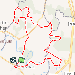
Randonnée Marche de 12,6 km à découvrir à Nouvelle-Aquitaine, Charente, Bernac. Cette randonnée est proposée par neoroll44.
Description
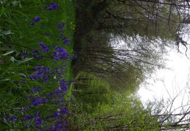
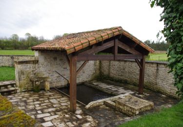
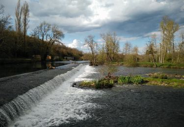
Circuit de la Font du Maçon (vert). Départ du parking du cimetière. Vers la Paizière, le bois des Jarris et le logis des Nouzières.
Localisation
Pays :
France
Région :
Nouvelle-Aquitaine
Département/Province :
Charente
Commune :
Bernac
Localité :
Unknown
Départ:(Dec)
Départ:(UTM)
280814 ; 5102862 (31T) N.
Commentaires
Randonnées à proximité
![Randonnée V.T.C. Condac - rejellant chassane - Photo](https://media.geolcdn.com/t/375/260/f941dbf9-6f50-4e7d-8c40-12817a339d98.jpg&format=jpg&maxdim=2)
![V.T.C. V.T.C.](https://static1.geolcdn.com/sitytour/trail-icons/203.png)
rejellant chassane
V.T.C.
Facile
Condac,
Nouvelle-Aquitaine,
Charente,
France
![](/images/other/stat-length.png)
17,5 km | 19,6 km-effort
5h 11min
![](https://static1.geolcdn.com/siteimages/upload/files/16400158638029165_repeat_loop_refresh_sync_direction_icon.png)
Non
![Randonnée Marche Ruffec - Ruffec_Logis - Photo](https://media.geolcdn.com/t/375/260/ext.jpg?maxdim=2&url=https%3A%2F%2Fservices.sitytrail.com%2FGeolivesWS%2FDownloadMedia.ashx%3FTrailID%3D556592%26Media%3D8a704e77-b4ef-4ee8-815d-c58a809173e3.JPG)
![Marche Marche](https://static1.geolcdn.com/sitytour/trail-icons/101.png)
Ruffec_Logis
Marche
Moyen
Ruffec,
Nouvelle-Aquitaine,
Charente,
France
![](/images/other/stat-length.png)
17,3 km | 19,7 km-effort
4h 20min
![](https://static1.geolcdn.com/siteimages/upload/files/16400158638029165_repeat_loop_refresh_sync_direction_icon.png)
Oui
![Randonnée Marche Condac - Condac - Photo](https://media.geolcdn.com/t/375/260/ext.jpg?maxdim=2&url=https%3A%2F%2Fservices.sitytrail.com%2FGeolivesWS%2FDownloadMedia.ashx%3FTrailID%3D556317%26Media%3Ddcadb249-373c-4f07-b689-15b2cfca5ca5.JPG)
![Marche Marche](https://static1.geolcdn.com/sitytour/trail-icons/101.png)
Condac
Marche
Moyen
Condac,
Nouvelle-Aquitaine,
Charente,
France
![](/images/other/stat-length.png)
11,2 km | 13,1 km-effort
3h 0min
![](https://static1.geolcdn.com/siteimages/upload/files/16400158638029165_repeat_loop_refresh_sync_direction_icon.png)
Oui
![Randonnée Marche Ruffec - Ruffec_Forêt - Photo](https://media.geolcdn.com/t/375/260/ext.jpg?maxdim=2&url=https%3A%2F%2Fservices.sitytrail.com%2FGeolivesWS%2FDownloadMedia.ashx%3FTrailID%3D554305%26Media%3D4db66742-d552-44a5-85d9-ad956cf37102.JPG)
![Marche Marche](https://static1.geolcdn.com/sitytour/trail-icons/101.png)
Ruffec_Forêt
Marche
Facile
Ruffec,
Nouvelle-Aquitaine,
Charente,
France
![](/images/other/stat-length.png)
8,5 km | 10 km-effort
2h 20min
![](https://static1.geolcdn.com/siteimages/upload/files/16400158638029165_repeat_loop_refresh_sync_direction_icon.png)
Oui
![Randonnée Marche Condac - Condac_Bioussac_Barro - Photo](https://media.geolcdn.com/t/375/260/ext.jpg?maxdim=2&url=https%3A%2F%2Fservices.sitytrail.com%2FGeolivesWS%2FDownloadMedia.ashx%3FTrailID%3D554281%26Media%3Dad2440e1-83f4-4ca4-9ca5-3c359047fce4.JPG)
![Marche Marche](https://static1.geolcdn.com/sitytour/trail-icons/101.png)
Condac_Bioussac_Barro
Marche
Moyen
Condac,
Nouvelle-Aquitaine,
Charente,
France
![](/images/other/stat-length.png)
26 km | 31 km-effort
6h 40min
![](https://static1.geolcdn.com/siteimages/upload/files/16400158638029165_repeat_loop_refresh_sync_direction_icon.png)
Oui
![Randonnée Marche Ruffec - Ruffec_Jardins - Photo](https://media.geolcdn.com/t/375/260/ext.jpg?maxdim=2&url=https%3A%2F%2Fservices.sitytrail.com%2FGeolivesWS%2FDownloadMedia.ashx%3FTrailID%3D555645%26Media%3Da0f43bbb-0193-406e-8ccd-743115a33ead.jpg)
![Marche Marche](https://static1.geolcdn.com/sitytour/trail-icons/101.png)
Ruffec_Jardins
Marche
Facile
(2)
Ruffec,
Nouvelle-Aquitaine,
Charente,
France
![](/images/other/stat-length.png)
5,4 km | 6,2 km-effort
1h 30min
![](https://static1.geolcdn.com/siteimages/upload/files/16400158638029165_repeat_loop_refresh_sync_direction_icon.png)
Oui
![Randonnée Marche Les Adjots - Les Adjots - Photo](https://media.geolcdn.com/t/375/260/ext.jpg?maxdim=2&url=https%3A%2F%2Fstatic1.geolcdn.com%2Fsiteimages%2Fupload%2Ffiles%2F1553511878bg_sport_marche.png)
![Marche Marche](https://static1.geolcdn.com/sitytour/trail-icons/101.png)
Les Adjots
Marche
Moyen
Les Adjots,
Nouvelle-Aquitaine,
Charente,
France
![](/images/other/stat-length.png)
17,5 km | 19,7 km-effort
4h 20min
![](https://static1.geolcdn.com/siteimages/upload/files/16400158638029165_repeat_loop_refresh_sync_direction_icon.png)
Oui
![Randonnée Marche La Faye - La Faye - Photo](https://media.geolcdn.com/t/375/260/ext.jpg?maxdim=2&url=https%3A%2F%2Fstatic1.geolcdn.com%2Fsiteimages%2Fupload%2Ffiles%2F1553511878bg_sport_marche.png)
![Marche Marche](https://static1.geolcdn.com/sitytour/trail-icons/101.png)
La Faye
Marche
Facile
La Faye,
Nouvelle-Aquitaine,
Charente,
France
![](/images/other/stat-length.png)
9 km | 10,1 km-effort
2h 20min
![](https://static1.geolcdn.com/siteimages/upload/files/16400158638029165_repeat_loop_refresh_sync_direction_icon.png)
Oui