Randonnée Marche Haspelschiedt - Haspelschiedt-Sturzelbronn - Photo

Haspelschiedt-Sturzelbronn

 edouard_bieber
edouard_bieber

Utilisateur

© OpenStreetMap contributors
Longueur
Longueur
21 km
Altitude max
Altitude max
427 m
Dénivelé positif
Dénivelé positif
570 m
Km-Effort
Km-Effort  
28 km
Altitude min
Altitude min
245 m
Dénivelé négatif
Dénivelé négatif
606 m
Boucle
Boucle
Non
Date de création :
2018-03-30 00:00:00.0
Dernière modification :
2018-03-30 00:00:00.0

(0 Avis)

Marche
Marche
5h57
Difficulté : Moyen

Scannez ce code QR pour ouvrir la randonnée dans l'application SityTrail

Application GPS de randonnée GRATUITE

Logo SityTrail SityTrail

IGN / Instituts géographiques

Télécharger SityTrail sur l'App Store Télécharger SityTrail sur Google Play

Logo SityTrail SityTrail World

Le monde est à vous

Télécharger SityTrail sur l'App Store Télécharger SityTrail sur Google Play Télécharger SityTrail sur Huawei AppGallery

À propos

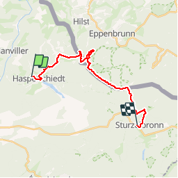
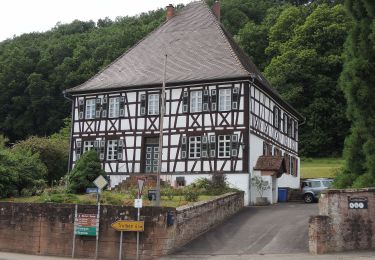
Randonnée Marche de 21 km à découvrir à Grand Est, Moselle, Haspelschiedt. Cette randonnée est proposée par edouard_bieber.

Description

19/04/2016

Profil altimétrique

Localisation

Pays :
France
Région :
Grand Est
Département/Province :
Moselle
Commune :
Haspelschiedt
Localité :
Unknown
Départ:(Dec)
Départ:(UTM)
389038 ; 5438327 (32U) N.

Randonnées à proximité

Randonnée Marche Roppeviller - Le rocher de l'Altschlossfelsen - Photo
Marche
VacheKiri67

Marche

Facile
(2)
Roppeviller, Grand Est, Moselle, France
13 km | 16,1 km-effort
3h 30min
Oui
Randonnée Marche Bitche - Circuit panoramique de Bitche - Photo
Marche
tracegps

Marche

Moyen
(2)
Bitche, Grand Est, Moselle, France
12,7 km | 16,7 km-effort
3h 25min
Oui
Randonnée A pied Hanviller - Chevalet jaune - Photo
A pied
GUIDE+

A pied

Facile
Hanviller, Grand Est, Moselle, France
6,3 km | 7,1 km-effort
1h 37min
Non
Randonnée A pied Schorbach - Anneau bleu - Photo
A pied
GUIDE+

A pied

Facile
Schorbach, Grand Est, Moselle, France
14,6 km | 18,7 km-effort
4h 15min
Oui
Randonnée A pied Bitche - Rectangle jaune-blanc-jaune - Photo
A pied
GUIDE+

A pied

Difficile
Bitche, Grand Est, Moselle, France
26 km | 35 km-effort
7h 58min
Non
Randonnée A pied Bitche - Chevalet jaune - Photo
A pied
GUIDE+

A pied

Facile
Bitche, Grand Est, Moselle, France
12,1 km | 18,2 km-effort
4h 7min
Non
Randonnée A pied Roppeviller - Circuit du rocher de l'Altschlossfelsen - Photo
A pied
GUIDE+

A pied

Facile
Roppeviller, Grand Est, Moselle, France
7,1 km | 9,7 km-effort
2h 12min
Oui
Randonnée A pied Eppenbrunn - Rundwanderweg Eppenbrunn 4 - Photo
A pied
GUIDE+

A pied

Facile
Eppenbrunn, Rhénanie-Palatinat, Südwestpfalz, Allemagne
7 km | 9,3 km-effort
2h 7min
Oui
Randonnée A pied Eppenbrunn - Grenzweg - Photo
A pied
GUIDE+

A pied

Facile
Eppenbrunn, Rhénanie-Palatinat, Südwestpfalz, Allemagne
11,3 km | 15 km-effort
3h 24min
Oui


Fermer
Mes abonnements