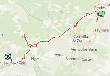
![](/images/other/stat-length.png)
![Randonnée Moteur Codalet - Prades - Villefranche de Conflent - Evol - Photo](https://media.geolcdn.com/t/1900/400/ext.pjpeg?maxdim=2&url=https%3A%2F%2Fservices.sitytrail.com%2FGeolivesWS%2FDownloadMedia.ashx%3FTrailID%3D554984%26Media%3D20160417170544.jpg)
Prades - Villefranche de Conflent - Evol
crijack
Utilisateur
![Longueur](/images/other/stat-length.png)
![Altitude max](https://static1.geolcdn.com/siteimages/upload/files/1508320355ic_sort_altitude_max_24dp.png)
![Dénivelé positif](https://static1.geolcdn.com/siteimages/upload/files/1508320355ic_sort_den_pos_24dp.png)
![Km-Effort](/images/other/stat-length.png)
![Altitude min](https://static1.geolcdn.com/siteimages/upload/files/1508320355ic_sort_altitude_min_24dp.png)
![Dénivelé négatif](https://static1.geolcdn.com/siteimages/upload/files/1508320355ic_sort_den_neg_24dp.png)
![Boucle](https://static1.geolcdn.com/siteimages/upload/files/16400158638029165_repeat_loop_refresh_sync_direction_icon.png)
![Moteur](https://static1.geolcdn.com/sitytour/trail-icons/400.png)
3h47
Difficulté : Facile
![Scannez ce code QR pour ouvrir la randonnée dans l'application SityTrail](https://capi.geolives.com/qq0zvz2zws4bq2lad0pu/sitytour/trails/554984/qr.png?size=200)
Application GPS de randonnée GRATUITE
À propos
Randonnée Moteur de 36 km à découvrir à Occitanie, Pyrénées-Orientales, Codalet. Cette randonnée est proposée par crijack.
Description
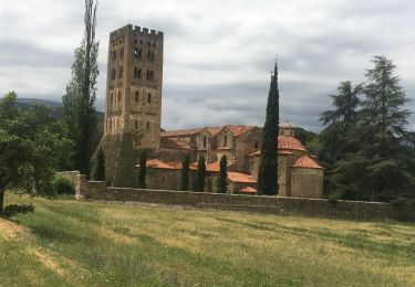
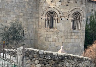
Route touristique au départ de Ste Marie de Cuxa, direction Font Romeu, arrêt à Villefranche de Conflent pour une promenade dans la ville fortifiée par Vauban, ensuite arrêt à Evol tout petit village pittoresque magnifique, petite promenade jusqu'à La Chapelle et les ruines du château qui surplombe ce petit village, pour enfin reprendre la route de Font Romeu et s'arrêter à l'air de Thuis où j'ai oublié de remettre en route SityTrail le voyage s'arrête donc là, prenez autant de plaisir que moi j'en ai pris par un dimanche ensoleillé.
Localisation
Commentaires
Randonnées à proximité
![Randonnée Marche Ria-Sirach - Sirach-Taurinya-Saint Michel de Cuxa - Photo](https://media.geolcdn.com/t/375/260/ext.jpg?maxdim=2&url=https%3A%2F%2Fservices.sitytrail.com%2FGeolivesWS%2FDownloadMedia.ashx%3FTrailID%3D631724%26Media%3D20160916113736.jpg)
![Marche Marche](https://static1.geolcdn.com/sitytour/trail-icons/101.png)
Marche
![](/images/other/stat-length.png)
![](https://static1.geolcdn.com/siteimages/upload/files/16400158638029165_repeat_loop_refresh_sync_direction_icon.png)
![Randonnée V.T.T. Ria-Sirach - cami del pi - Photo](https://media.geolcdn.com/t/375/260/ext.jpg?maxdim=2&url=https%3A%2F%2Fstatic1.geolcdn.com%2Fsiteimages%2Fupload%2Ffiles%2F1524743154velo.jpg)
![V.T.T. V.T.T.](https://static1.geolcdn.com/sitytour/trail-icons/202.png)
V.T.T.
![](/images/other/stat-length.png)
![](https://static1.geolcdn.com/siteimages/upload/files/16400158638029165_repeat_loop_refresh_sync_direction_icon.png)
![Randonnée Marche Taurinya - le Canigou depuis le col de Millères - Photo](https://media.geolcdn.com/t/375/260/ext.jpg?maxdim=2&url=https%3A%2F%2Fstatic1.geolcdn.com%2Fsiteimages%2Fupload%2Ffiles%2F1553511878bg_sport_marche.png)
![Marche Marche](https://static1.geolcdn.com/sitytour/trail-icons/101.png)
Marche
![](/images/other/stat-length.png)
![](https://static1.geolcdn.com/siteimages/upload/files/16400158638029165_repeat_loop_refresh_sync_direction_icon.png)
![Randonnée Marche Taurinya - b - Photo](https://media.geolcdn.com/t/375/260/3dd340e8-99b2-41f7-a00f-44f941b5bfec.jpg&format=jpg&maxdim=2)
![Marche Marche](https://static1.geolcdn.com/sitytour/trail-icons/101.png)
Marche
![](/images/other/stat-length.png)
![](https://static1.geolcdn.com/siteimages/upload/files/16400158638029165_repeat_loop_refresh_sync_direction_icon.png)
![Randonnée sport Corneilla-de-Conflent - 20241219 Boucle depuis Villefranche-de-Conflent - Photo](https://media.geolcdn.com/t/375/260/181e15a5-6185-4f02-acf7-8c66afb44142.jpg&format=jpg&maxdim=2)
sport
![](/images/other/stat-length.png)
![](https://static1.geolcdn.com/siteimages/upload/files/16400158638029165_repeat_loop_refresh_sync_direction_icon.png)
![Randonnée Marche Codalet - le tour de saint Michel de cuxià - Photo](https://media.geolcdn.com/t/375/260/f5bc736e-d2e4-4509-97da-24e2dac475ec.jpg&format=jpg&maxdim=2)
![Marche Marche](https://static1.geolcdn.com/sitytour/trail-icons/101.png)
Marche
![](/images/other/stat-length.png)
![](https://static1.geolcdn.com/siteimages/upload/files/16400158638029165_repeat_loop_refresh_sync_direction_icon.png)
![Randonnée Marche Codalet - Codalet /Taurinya / St Michel de cuca - Photo](https://media.geolcdn.com/t/375/260/79b1aac1-078d-49c1-b315-5474fef3ade2.jpg&format=jpg&maxdim=2)
![Marche Marche](https://static1.geolcdn.com/sitytour/trail-icons/101.png)
Marche
![](/images/other/stat-length.png)
![](https://static1.geolcdn.com/siteimages/upload/files/16400158638029165_repeat_loop_refresh_sync_direction_icon.png)
![Randonnée Marche Fuilla - fuilla (66) - Photo](https://media.geolcdn.com/t/375/260/52a4cc98-58c8-4d12-9f81-88a2231fa3d3.jpg&format=jpg&maxdim=2)
![Marche Marche](https://static1.geolcdn.com/sitytour/trail-icons/101.png)
Marche
![](/images/other/stat-length.png)
![](https://static1.geolcdn.com/siteimages/upload/files/16400158638029165_repeat_loop_refresh_sync_direction_icon.png)
![Randonnée Marche Corneilla-de-Conflent - Corneilla de Conflent - Photo](https://media.geolcdn.com/t/375/260/87184567-2ca4-4199-b850-a35026a3725a.jpg&format=jpg&maxdim=2)
![Marche Marche](https://static1.geolcdn.com/sitytour/trail-icons/101.png)
Marche
![](/images/other/stat-length.png)
![](https://static1.geolcdn.com/siteimages/upload/files/16400158638029165_repeat_loop_refresh_sync_direction_icon.png)
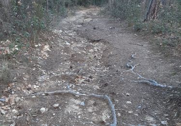
Superbe circuit alliant balade en voiture et petite randonnée pédestre