![](/images/other/stat-length.png)
![Randonnée Marche Ventes-Saint-Rémy - Forêt d'Eawy 2016-04-28 - GD 11km - Photo](https://media.geolcdn.com/t/1900/400/ext.pjpeg?maxdim=2&url=https%3A%2F%2Fstatic1.geolcdn.com%2Fsiteimages%2Fupload%2Ffiles%2F1553511878bg_sport_marche.png)
Forêt d'Eawy 2016-04-28 - GD 11km
philippe76
Utilisateur
![Longueur](/images/other/stat-length.png)
![Altitude max](https://static1.geolcdn.com/siteimages/upload/files/1508320355ic_sort_altitude_max_24dp.png)
![Dénivelé positif](https://static1.geolcdn.com/siteimages/upload/files/1508320355ic_sort_den_pos_24dp.png)
![Km-Effort](/images/other/stat-length.png)
![Altitude min](https://static1.geolcdn.com/siteimages/upload/files/1508320355ic_sort_altitude_min_24dp.png)
![Dénivelé négatif](https://static1.geolcdn.com/siteimages/upload/files/1508320355ic_sort_den_neg_24dp.png)
![Boucle](https://static1.geolcdn.com/siteimages/upload/files/16400158638029165_repeat_loop_refresh_sync_direction_icon.png)
![Marche](https://static1.geolcdn.com/sitytour/trail-icons/101.png)
2h52
Difficulté : Facile
![Scannez ce code QR pour ouvrir la randonnée dans l'application SityTrail](https://capi.geolives.com/qq0zvz2zws4bq2lad0pu/sitytour/trails/554953/qr.png?size=200)
Application GPS de randonnée GRATUITE
À propos
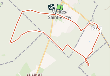
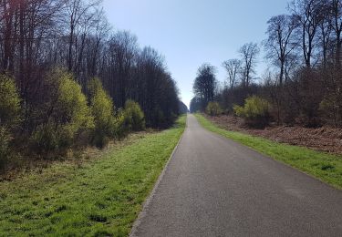
Randonnée Marche de 10,9 km à découvrir à Normandie, Seine-Maritime, Ventes-Saint-Rémy. Cette randonnée est proposée par philippe76.
Description
départ aux Ventes-St-Rémy, au parking du jardin du roi de Rome. Prende la rte fre de l'église, puis AG rte fre des trois Saules. Au carrefour des Saules prendre AG le chemin vert. TD jusqu'au carrefour Alt 165? AG rte du fond St Etienne, jusqu'au carrefour George Bénard. AD rte fre des Limousins, couper la D12, jusqu'au carrefour Alt 193; AG, AD jusqu'à alt 205.
PETITE : AG pour longer le Camp Souverain, le chemin des écoliers, AG et rejoindre la rte de l'église jusqu'au PKG.
GRANDE : TD jusqu'à la rte fre de Bully, la traverser et aller au Puits Merveilleux. Revenir à la rte fre, et prendre le sentier botanique pour longer le Camp Souverain. TD dans le sentier, traverser la D118 et prendre le chemin des écoliers. puis à l'endroit le Carcahoux AD et rejoindre la rte de l'église et le PKG;
Localisation
Commentaires
Randonnées à proximité
![Randonnée Marche Ventes-Saint-Rémy - Forêt d'Eawy rando douce - Photo](https://media.geolcdn.com/t/375/260/46ed799a-be1a-46c2-a0e8-32b921a7c1f2.jpg&format=jpg&maxdim=2)
![Marche Marche](https://static1.geolcdn.com/sitytour/trail-icons/101.png)
Marche
![](/images/other/stat-length.png)
![](https://static1.geolcdn.com/siteimages/upload/files/16400158638029165_repeat_loop_refresh_sync_direction_icon.png)
![Randonnée Marche Ventes-Saint-Rémy - Ventes St Remy 76 - Photo](https://media.geolcdn.com/t/375/260/48ee858b-9520-454b-b6ed-e614f9b4caff.jpg&format=jpg&maxdim=2)
![Marche Marche](https://static1.geolcdn.com/sitytour/trail-icons/101.png)
Marche
![](/images/other/stat-length.png)
![](https://static1.geolcdn.com/siteimages/upload/files/16400158638029165_repeat_loop_refresh_sync_direction_icon.png)
![Marche Marche](https://static1.geolcdn.com/sitytour/trail-icons/101.png)
Marche
![](/images/other/stat-length.png)
![](https://static1.geolcdn.com/siteimages/upload/files/16400158638029165_repeat_loop_refresh_sync_direction_icon.png)
![Marche Marche](https://static1.geolcdn.com/sitytour/trail-icons/101.png)
Marche
![](/images/other/stat-length.png)
![](https://static1.geolcdn.com/siteimages/upload/files/16400158638029165_repeat_loop_refresh_sync_direction_icon.png)
![Randonnée Marche Saint-Saëns - 20190404 st saens - Photo](https://media.geolcdn.com/t/375/260/9151aba8-5cfd-4af0-b66f-cbd6d119bb92.jpg&format=jpg&maxdim=2)
![Marche Marche](https://static1.geolcdn.com/sitytour/trail-icons/101.png)
Marche
![](/images/other/stat-length.png)
![](https://static1.geolcdn.com/siteimages/upload/files/16400158638029165_repeat_loop_refresh_sync_direction_icon.png)
![Randonnée Marche Saint-Saëns - 20190404 st saens - Photo](https://media.geolcdn.com/t/375/260/file:///storage/emulated/0/Android/data/com.geolives.apps.sitytrail.beta/files/ressources/captured_photos/20180706151129.jpg&format=jpg&maxdim=2)
![Marche Marche](https://static1.geolcdn.com/sitytour/trail-icons/101.png)
Marche
![](/images/other/stat-length.png)
![](https://static1.geolcdn.com/siteimages/upload/files/16400158638029165_repeat_loop_refresh_sync_direction_icon.png)
![Randonnée Marche Saint-Saëns - 20160428-St Saens - Photo](https://media.geolcdn.com/t/375/260/ext.jpg?maxdim=2&url=https%3A%2F%2Fservices.sitytrail.com%2FGeolivesWS%2FDownloadMedia.ashx%3FTrailID%3D560247%26Media%3Dd971c4ae-ceef-469f-a1b9-979b7cf70306.JPG)
![Marche Marche](https://static1.geolcdn.com/sitytour/trail-icons/101.png)
Marche
![](/images/other/stat-length.png)
![](https://static1.geolcdn.com/siteimages/upload/files/16400158638029165_repeat_loop_refresh_sync_direction_icon.png)