Randonnée Marche Savonnières-en-Perthois - 17/17a Vallées de l'Ornain et de la Saulx - Photo

17/17a Vallées de l'Ornain et de la Saulx

 cath310
cath310

Utilisateur

© OpenStreetMap contributors
Longueur
Longueur
26 km
Altitude max
Altitude max
298 m
Dénivelé positif
Dénivelé positif
384 m
Km-Effort
Km-Effort  
31 km
Altitude min
Altitude min
161 m
Dénivelé négatif
Dénivelé négatif
375 m
Boucle
Boucle
Oui
Date de création :
2016-04-11 00:00:00.0
Dernière modification :
2016-04-11 00:00:00.0

(2 Avis)

Marche
Marche
6h45
Difficulté : Moyen

Scannez ce code QR pour ouvrir la randonnée dans l'application SityTrail

Application GPS de randonnée GRATUITE

Logo SityTrail SityTrail

IGN / Instituts géographiques

Télécharger SityTrail sur l'App Store Télécharger SityTrail sur Google Play

Logo SityTrail SityTrail World

Le monde est à vous

Télécharger SityTrail sur l'App Store Télécharger SityTrail sur Google Play Télécharger SityTrail sur Huawei AppGallery

À propos

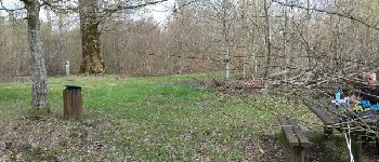
Randonnée Marche de 26 km à découvrir à Grand Est, Meuse, Savonnières-en-Perthois. Cette randonnée est proposée par cath310.

Description

D/R : SAVONNIERES-EN-PERTHOIS
Place de l'église
sur la route chêne PARIS-SAIGON avc coin pique-nique, abbaye de Jovilliers...
tbelle randonnée faite le 10/04/2016

Profil altimétrique

Photos

Points d'intérêt

Point d'intérêt Juvigny-en-Perthois - Point 1 - Photo
cath310
JUVIGNY-EN-PERTHOIS 
Point d'intérêt Stainville - Point 3 - Photo
cath310
STAINVILLE 
Point d'intérêt Stainville - Point 4 - Photo
cath310
STAINVILLE 
Point d'intérêt Savonnières-en-Perthois - Point 5 - Photo
cath310
SAVONNIÈRES-EN-PERTHOIS 
Point d'intérêt Aulnois-en-Perthois - Point 7 - Photo
cath310
AULNOIS-EN-PERTHOIS 

Localisation

Pays :
France
Région :
Grand Est
Département/Province :
Meuse
Commune :
Savonnières-en-Perthois
Localité :
Unknown
Départ:(Dec)
Départ:(UTM)
657064 ; 5385520 (31U) N.

Commentaires

Veuillez vous connecter pour laisser un commentaire ou une note


tbelle randonnée


tbelle randonnée


Randonnées à proximité

Randonnée Marche Aulnois-en-Perthois - Aulnoye en Perthois - Photo
Marche
JD51290

Marche

Très facile
(1)
Aulnois-en-Perthois, Grand Est, Meuse, France
24 km | 28 km-effort
6h 26min
Oui
Randonnée Marche Cousances-les-Forges - Cousancelles église Claude - Photo
Marche
René Kovac

Marche

Cousances-les-Forges, Grand Est, Meuse, France
8,5 km | 10,1 km-effort
2h 33min
Oui
Randonnée Marche Cousances-les-Forges - Cousancelles église  - Photo
Marche
René Kovac

Marche

Cousances-les-Forges, Grand Est, Meuse, France
10,2 km | 12,3 km-effort
2h 50min
Oui
Randonnée V.T.T. Narcy - Circuit Les fourmies rouges NARCY  - Photo
V.T.T.
delestrai

V.T.T.

Facile
Narcy, Grand Est, Haute-Marne, France
12 km | 14,8 km-effort
1h 30min
Oui
Randonnée V.T.T. Narcy -  Circuit du grand étang NARCY - Photo
V.T.T.
delestrai

V.T.T.

Facile
Narcy, Grand Est, Haute-Marne, France
7,9 km | 9,5 km-effort
1h 0min
Oui
Randonnée Marche Stainville - paris saigon - Photo
Marche
cath310

Marche

Moyen
Stainville, Grand Est, Meuse, France
20 km | 23 km-effort
4h 12min
Oui
Randonnée Marche Cousances-les-Forges - Cousancelles église (Claude) - Photo
Marche
René Kovac

Marche

Cousances-les-Forges, Grand Est, Meuse, France
10,9 km | 12,9 km-effort
3h 8min
Oui
Randonnée Marche Juvigny-en-Perthois - Juvigny en Perthois  - Photo
Marche
René Kovac

Marche

Juvigny-en-Perthois, Grand Est, Meuse, France
10,3 km | 12,2 km-effort
2h 54min
Oui
Randonnée Marche Narcy - Narcy étang - Photo
Marche
René Kovac

Marche

Narcy, Grand Est, Haute-Marne, France
9,8 km | 11,9 km-effort
3h 9min
Oui


Fermer
Mes abonnements