![](/images/other/stat-length.png)
![Randonnée V.T.T. Braine-l'Alleud - VTT de Waterloo - Photo](https://media.geolcdn.com/t/1900/400/ext.pjpeg?maxdim=2&url=https%3A%2F%2Fservices.sitytrail.com%2FGeolivesWS%2FDownloadMedia.ashx%3FTrailID%3D550473%26Media%3Ddfde0240-b743-4900-be5a-df0504f029fd.jpg)
VTT de Waterloo
pascalou73
Utilisateur GUIDE
![Longueur](/images/other/stat-length.png)
Longueur
36 km
![Altitude max](https://static1.geolcdn.com/siteimages/upload/files/1508320355ic_sort_altitude_max_24dp.png)
Altitude max
152 m
![Dénivelé positif](https://static1.geolcdn.com/siteimages/upload/files/1508320355ic_sort_den_pos_24dp.png)
Dénivelé positif
554 m
![Km-Effort](/images/other/stat-length.png)
Km-Effort
43 km
![Altitude min](https://static1.geolcdn.com/siteimages/upload/files/1508320355ic_sort_altitude_min_24dp.png)
Altitude min
71 m
![Dénivelé négatif](https://static1.geolcdn.com/siteimages/upload/files/1508320355ic_sort_den_neg_24dp.png)
Dénivelé négatif
553 m
![Boucle](https://static1.geolcdn.com/siteimages/upload/files/16400158638029165_repeat_loop_refresh_sync_direction_icon.png)
Boucle
Oui
Date de création :
2016-04-07 00:00:00.0
Dernière modification :
2016-04-07 00:00:00.0
![V.T.T.](https://static1.geolcdn.com/sitytour/trail-icons/202.png)
2h52
Difficulté : Moyen
![Scannez ce code QR pour ouvrir la randonnée dans l'application SityTrail](https://capi.geolives.com/qq0zvz2zws4bq2lad0pu/sitytour/trails/550473/qr.png?size=200)
Application GPS de randonnée GRATUITE
À propos
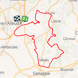
Randonnée V.T.T. de 36 km à découvrir à Wallonie, Brabant wallon, Braine-l'Alleud. Cette randonnée est proposée par pascalou73.
Description
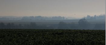
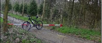
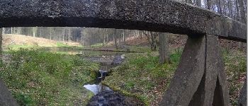
Une belle rando en VTT dans la province du Brabant Wallon. Au départ de la butte du lion de Waterloo.Elle permet de découvrir des villages de beaux sentiers.la beauté des paysages de cette rando offre une belle occasion de découvrir le patrimoine naturel
Localisation
Pays :
Belgique
Région :
Wallonie
Département/Province :
Brabant wallon
Commune :
Braine-l'Alleud
Localité :
Braine-l'Alleud
Départ:(Dec)
Départ:(UTM)
599238 ; 5615104 (31U) N.
Commentaires
Randonnées à proximité
![Randonnée Marche Braine-l'Alleud - RB-Bw-13_Braine-l'Alleud - Photo](https://media.geolcdn.com/t/375/260/ext.jpg?maxdim=2&url=https%3A%2F%2Fservices.sitytrail.com%2FGeolivesWS%2FDownloadMedia.ashx%3FTrailID%3D179588%26Media%3D9ffdd7b7-2039-4356-b235-ee33d9a18bd7.jpg)
![Marche Marche](https://static1.geolcdn.com/sitytour/trail-icons/101.png)
RB-Bw-13_Braine-l'Alleud
Marche
Très difficile
(5)
Braine-l'Alleud,
Wallonie,
Brabant wallon,
Belgique
![](/images/other/stat-length.png)
21 km | 27 km-effort
6h 2min
![](https://static1.geolcdn.com/siteimages/upload/files/16400158638029165_repeat_loop_refresh_sync_direction_icon.png)
Oui
![Randonnée Marche Braine-l'Alleud - RB-Bw-13_Braine-l'Alleud_via-racc-1-et-var - Photo](https://media.geolcdn.com/t/375/260/ext.jpg?maxdim=2&url=https%3A%2F%2Fservices.sitytrail.com%2FGeolivesWS%2FDownloadMedia.ashx%3FTrailID%3D220430%26Media%3D9ffdd7b7-2039-4356-b235-ee33d9a18bd7.jpg)
![Marche Marche](https://static1.geolcdn.com/sitytour/trail-icons/101.png)
RB-Bw-13_Braine-l'Alleud_via-racc-1-et-var
Marche
Difficile
(6)
Braine-l'Alleud,
Wallonie,
Brabant wallon,
Belgique
![](/images/other/stat-length.png)
14,8 km | 18,8 km-effort
4h 16min
![](https://static1.geolcdn.com/siteimages/upload/files/16400158638029165_repeat_loop_refresh_sync_direction_icon.png)
Oui
![Randonnée V.T.T. Braine-l'Alleud - O2bikers_58_Waterloo - Photo](https://media.geolcdn.com/t/375/260/ext.jpg?maxdim=2&url=https%3A%2F%2Fstatic1.geolcdn.com%2Fsiteimages%2Fupload%2Ffiles%2F1524743154velo.jpg)
![V.T.T. V.T.T.](https://static1.geolcdn.com/sitytour/trail-icons/202.png)
O2bikers_58_Waterloo
V.T.T.
Très facile
(5)
Braine-l'Alleud,
Wallonie,
Brabant wallon,
Belgique
![](/images/other/stat-length.png)
30 km | 37 km-effort
4h 11min
![](https://static1.geolcdn.com/siteimages/upload/files/16400158638029165_repeat_loop_refresh_sync_direction_icon.png)
Oui
![V.T.T. V.T.T.](https://static1.geolcdn.com/sitytour/trail-icons/202.png)
VTT de Maransart à la forêt de soigne
V.T.T.
Difficile
(1)
Lasne,
Wallonie,
Brabant wallon,
Belgique
![](/images/other/stat-length.png)
40 km | 49 km-effort
Inconnu
![](https://static1.geolcdn.com/siteimages/upload/files/16400158638029165_repeat_loop_refresh_sync_direction_icon.png)
Oui
![V.T.T. V.T.T.](https://static1.geolcdn.com/sitytour/trail-icons/202.png)
VTT a plancenoit
V.T.T.
Difficile
(1)
Lasne,
Wallonie,
Brabant wallon,
Belgique
![](/images/other/stat-length.png)
28 km | 34 km-effort
2h 20min
![](https://static1.geolcdn.com/siteimages/upload/files/16400158638029165_repeat_loop_refresh_sync_direction_icon.png)
Oui
![Randonnée V.T.T. Waterloo - De Waterloo à la forêt de Soignes - Photo](https://media.geolcdn.com/t/375/260/ext.jpg?maxdim=2&url=https%3A%2F%2Fservices.sitytrail.com%2FGeolivesWS%2FDownloadMedia.ashx%3FTrailID%3D688453%26Media%3D31ac41f9-68d5-4a4a-9a8e-a882e9787769.JPG)
![V.T.T. V.T.T.](https://static1.geolcdn.com/sitytour/trail-icons/202.png)
De Waterloo à la forêt de Soignes
V.T.T.
Moyen
(1)
Waterloo,
Wallonie,
Brabant wallon,
Belgique
![](/images/other/stat-length.png)
39 km | 47 km-effort
3h 1min
![](https://static1.geolcdn.com/siteimages/upload/files/16400158638029165_repeat_loop_refresh_sync_direction_icon.png)
Oui
![Marche Marche](https://static1.geolcdn.com/sitytour/trail-icons/101.png)
#240315 - Ohain Golf de Waterloo Marache****
Marche
Moyen
(1)
Lasne,
Wallonie,
Brabant wallon,
Belgique
![](/images/other/stat-length.png)
6,3 km | 7,4 km-effort
1h 41min
![](https://static1.geolcdn.com/siteimages/upload/files/16400158638029165_repeat_loop_refresh_sync_direction_icon.png)
Oui
![Randonnée Marche Braine-l'Alleud - #221003 - Braine-l'Alleud, Timpe et Tard et Bois du Foriest, Parc et Lac du Paradis**** - Photo](https://media.geolcdn.com/t/375/260/7ca9587d-0fe0-4627-96a6-2d18fe7f584a.jpg&format=jpg&maxdim=2)
![Marche Marche](https://static1.geolcdn.com/sitytour/trail-icons/101.png)
#221003 - Braine-l'Alleud, Timpe et Tard et Bois du Foriest, Parc et Lac du P...
Marche
Moyen
(1)
Braine-l'Alleud,
Wallonie,
Brabant wallon,
Belgique
![](/images/other/stat-length.png)
8,1 km | 9,8 km-effort
2h 13min
![](https://static1.geolcdn.com/siteimages/upload/files/16400158638029165_repeat_loop_refresh_sync_direction_icon.png)
Oui
![Marche Marche](https://static1.geolcdn.com/sitytour/trail-icons/101.png)
RB 11 Plancenoit - Lasnes
Marche
Facile
(1)
Lasne,
Wallonie,
Brabant wallon,
Belgique
![](/images/other/stat-length.png)
12,8 km | 15,6 km-effort
2h 42min
![](https://static1.geolcdn.com/siteimages/upload/files/16400158638029165_repeat_loop_refresh_sync_direction_icon.png)
Oui