![](/images/other/stat-length.png)
![Randonnée Marche Profondeville - LUSTIN (N-D de le Salette) - Photo](https://media.geolcdn.com/t/1900/400/ext.pjpeg?maxdim=2&url=https%3A%2F%2Fservices.sitytrail.com%2FGeolivesWS%2FDownloadMedia.ashx%3FTrailID%3D548265%26Media%3Dfix__20160403102737.jpg)
LUSTIN (N-D de le Salette)
GerardBouche
Utilisateur
![Longueur](/images/other/stat-length.png)
Longueur
11,1 km
![Altitude max](https://static1.geolcdn.com/siteimages/upload/files/1508320355ic_sort_altitude_max_24dp.png)
Altitude max
279 m
![Dénivelé positif](https://static1.geolcdn.com/siteimages/upload/files/1508320355ic_sort_den_pos_24dp.png)
Dénivelé positif
217 m
![Km-Effort](/images/other/stat-length.png)
Km-Effort
14 km
![Altitude min](https://static1.geolcdn.com/siteimages/upload/files/1508320355ic_sort_altitude_min_24dp.png)
Altitude min
167 m
![Dénivelé négatif](https://static1.geolcdn.com/siteimages/upload/files/1508320355ic_sort_den_neg_24dp.png)
Dénivelé négatif
217 m
![Boucle](https://static1.geolcdn.com/siteimages/upload/files/16400158638029165_repeat_loop_refresh_sync_direction_icon.png)
Boucle
Oui
Date de création :
2016-04-03 00:00:00.0
Dernière modification :
2016-04-03 00:00:00.0
![Marche](https://static1.geolcdn.com/sitytour/trail-icons/101.png)
3h01
Difficulté : Facile
![Scannez ce code QR pour ouvrir la randonnée dans l'application SityTrail](https://capi.geolives.com/qq0zvz2zws4bq2lad0pu/sitytour/trails/548265/qr.png?size=200)
Application GPS de randonnée GRATUITE
À propos
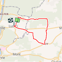
Randonnée Marche de 11,1 km à découvrir à Wallonie, Namur, Profondeville. Cette randonnée est proposée par GerardBouche.
Description
Par le Fond d'Arche vers la chapelle de la Salette, le Château Fme-d'Arche, la chapelle St-Martin d'Ivoy et l'aérodrome de Maillen.
Localisation
Pays :
Belgique
Région :
Wallonie
Département/Province :
Namur
Commune :
Profondeville
Localité :
Lustin
Départ:(Dec)
Départ:(UTM)
634967 ; 5582561 (31U) N.
Commentaires
Randonnées à proximité
![Randonnée Marche Profondeville - RL-GG-19_Lustin_Namur - Photo](https://media.geolcdn.com/t/375/260/ext.jpg?maxdim=2&url=https%3A%2F%2Fmedia.geolcdn.com%2Ff%2Fb0b5ef2e-bf0c-4965-a3a2-62d0da2d07c7.jpg)
![Marche Marche](https://static1.geolcdn.com/sitytour/trail-icons/101.png)
RL-GG-19_Lustin_Namur
Marche
Très difficile
(13)
Profondeville,
Wallonie,
Namur,
Belgique
![](/images/other/stat-length.png)
22 km | 28 km-effort
6h 7min
![](https://static1.geolcdn.com/siteimages/upload/files/16400158638029165_repeat_loop_refresh_sync_direction_icon.png)
Non
![Randonnée Marche Yvoir - RB-Na-21_Mont - Photo](https://media.geolcdn.com/t/375/260/ext.jpg?maxdim=2&url=https%3A%2F%2Fmedia.geolcdn.com%2Ff%2F77bdfe07-c4c1-4d1b-a54a-f48ca19ed07c.JPG)
![Marche Marche](https://static1.geolcdn.com/sitytour/trail-icons/101.png)
RB-Na-21_Mont
Marche
Très difficile
(6)
Yvoir,
Wallonie,
Namur,
Belgique
![](/images/other/stat-length.png)
22 km | 30 km-effort
6h 51min
![](https://static1.geolcdn.com/siteimages/upload/files/16400158638029165_repeat_loop_refresh_sync_direction_icon.png)
Oui
![Randonnée Marche Profondeville - RB-Na-20_Profondeville_via-racc-2 - Photo](https://media.geolcdn.com/t/375/260/ext.jpg?maxdim=2&url=https%3A%2F%2Fmedia.geolcdn.com%2Ff%2F8204f516-cdb2-4e3b-8381-1ddcd8c9015d.JPG)
![Marche Marche](https://static1.geolcdn.com/sitytour/trail-icons/101.png)
RB-Na-20_Profondeville_via-racc-2
Marche
Très difficile
(11)
Profondeville,
Wallonie,
Namur,
Belgique
![](/images/other/stat-length.png)
14,6 km | 22 km-effort
4h 53min
![](https://static1.geolcdn.com/siteimages/upload/files/16400158638029165_repeat_loop_refresh_sync_direction_icon.png)
Oui
![Randonnée Marche Profondeville - RB-Na-20_Profondeville - Photo](https://media.geolcdn.com/t/375/260/ext.jpg?maxdim=2&url=https%3A%2F%2Fmedia.geolcdn.com%2Ff%2F62b35a3a-8c39-4ffb-925a-863a1d62e013.JPG)
![Marche Marche](https://static1.geolcdn.com/sitytour/trail-icons/101.png)
RB-Na-20_Profondeville
Marche
Très difficile
(15)
Profondeville,
Wallonie,
Namur,
Belgique
![](/images/other/stat-length.png)
18,5 km | 26 km-effort
5h 55min
![](https://static1.geolcdn.com/siteimages/upload/files/16400158638029165_repeat_loop_refresh_sync_direction_icon.png)
Oui
![Randonnée Marche Assesse - RB-Na-02_Crupet_via-racc - Photo](https://media.geolcdn.com/t/375/260/ext.jpg?maxdim=2&url=https%3A%2F%2Fservices.sitytrail.com%2FGeolivesWS%2FDownloadMedia.ashx%3FTrailID%3D794014%26Media%3Dc4c97e29-7bfb-495c-ae56-13528ce8d0b3.JPG)
![Marche Marche](https://static1.geolcdn.com/sitytour/trail-icons/101.png)
RB-Na-02_Crupet_via-racc
Marche
Moyen
(7)
Assesse,
Wallonie,
Namur,
Belgique
![](/images/other/stat-length.png)
17 km | 23 km-effort
5h 32min
![](https://static1.geolcdn.com/siteimages/upload/files/16400158638029165_repeat_loop_refresh_sync_direction_icon.png)
Oui
![Randonnée Marche Assesse - RB-Na-02_Crupet - Photo](https://media.geolcdn.com/t/375/260/ext.jpg?maxdim=2&url=https%3A%2F%2Fservices.sitytrail.com%2FGeolivesWS%2FDownloadMedia.ashx%3FTrailID%3D250531%26Media%3Dc4c97e29-7bfb-495c-ae56-13528ce8d0b3.JPG)
![Marche Marche](https://static1.geolcdn.com/sitytour/trail-icons/101.png)
RB-Na-02_Crupet
Marche
Moyen
(20)
Assesse,
Wallonie,
Namur,
Belgique
![](/images/other/stat-length.png)
21 km | 28 km-effort
5h 32min
![](https://static1.geolcdn.com/siteimages/upload/files/16400158638029165_repeat_loop_refresh_sync_direction_icon.png)
Oui
![Randonnée Marche Assesse - 05 Paysage condruzien - Photo](https://media.geolcdn.com/t/375/260/ext.jpg?maxdim=2&url=https%3A%2F%2Fservices.sitytrail.com%2FGeolivesWS%2FDownloadMedia.ashx%3FTrailID%3D121392%26Media%3D31d83d0c-5bcd-44cd-b8d6-1cc6a3d25bf9.jpg)
![Marche Marche](https://static1.geolcdn.com/sitytour/trail-icons/101.png)
05 Paysage condruzien
Marche
Facile
(5)
Assesse,
Wallonie,
Namur,
Belgique
![](/images/other/stat-length.png)
10,2 km | 13,3 km-effort
2h 11min
![](https://static1.geolcdn.com/siteimages/upload/files/16400158638029165_repeat_loop_refresh_sync_direction_icon.png)
Non
![Randonnée Marche Yvoir - RL-GG-38_Godinne_Dinant - Photo](https://media.geolcdn.com/t/375/260/ext.jpg?maxdim=2&url=https%3A%2F%2Fmedia.geolcdn.com%2Ff%2F4b7f8162-b405-4557-afe1-7567462c4aff.jpg)
![Marche Marche](https://static1.geolcdn.com/sitytour/trail-icons/101.png)
RL-GG-38_Godinne_Dinant
Marche
Très difficile
(6)
Yvoir,
Wallonie,
Namur,
Belgique
![](/images/other/stat-length.png)
19,5 km | 27 km-effort
6h 13min
![](https://static1.geolcdn.com/siteimages/upload/files/16400158638029165_repeat_loop_refresh_sync_direction_icon.png)
Non
![Randonnée Marche Anhée - RF-Na-05 Annevoie, côté Jardins_Grande-boucle - Photo](https://media.geolcdn.com/t/375/260/ext.jpg?maxdim=2&url=https%3A%2F%2Fservices.sitytrail.com%2FGeolivesWS%2FDownloadMedia.ashx%3FTrailID%3D545753%26Media%3D5d973c83-4a6c-40fc-a026-25de6c754887.JPG)
![Marche Marche](https://static1.geolcdn.com/sitytour/trail-icons/101.png)
RF-Na-05 Annevoie, côté Jardins_Grande-boucle
Marche
Moyen
(11)
Anhée,
Wallonie,
Namur,
Belgique
![](/images/other/stat-length.png)
11,3 km | 14,5 km-effort
3h 6min
![](https://static1.geolcdn.com/siteimages/upload/files/16400158638029165_repeat_loop_refresh_sync_direction_icon.png)
Oui