![](/images/other/stat-length.png)
![Randonnée Marche Tours - Rochecorbon - Photo](https://media.geolcdn.com/t/1900/400/ext.pjpeg?maxdim=2&url=https%3A%2F%2Fservices.sitytrail.com%2FGeolivesWS%2FDownloadMedia.ashx%3FTrailID%3D546447%26Media%3Dfix__20160330135209.jpg)
Rochecorbon
Daguier
Utilisateur
![Longueur](/images/other/stat-length.png)
Longueur
16,5 km
![Altitude max](https://static1.geolcdn.com/siteimages/upload/files/1508320355ic_sort_altitude_max_24dp.png)
Altitude max
104 m
![Dénivelé positif](https://static1.geolcdn.com/siteimages/upload/files/1508320355ic_sort_den_pos_24dp.png)
Dénivelé positif
202 m
![Km-Effort](/images/other/stat-length.png)
Km-Effort
19,1 km
![Altitude min](https://static1.geolcdn.com/siteimages/upload/files/1508320355ic_sort_altitude_min_24dp.png)
Altitude min
44 m
![Dénivelé négatif](https://static1.geolcdn.com/siteimages/upload/files/1508320355ic_sort_den_neg_24dp.png)
Dénivelé négatif
173 m
![Boucle](https://static1.geolcdn.com/siteimages/upload/files/16400158638029165_repeat_loop_refresh_sync_direction_icon.png)
Boucle
Non
Date de création :
2016-03-30 00:00:00.0
Dernière modification :
2016-03-30 00:00:00.0
![Marche](https://static1.geolcdn.com/sitytour/trail-icons/101.png)
3h37
Difficulté : Inconnu
![Scannez ce code QR pour ouvrir la randonnée dans l'application SityTrail](https://capi.geolives.com/qq0zvz2zws4bq2lad0pu/sitytour/trails/546447/qr.png?size=200)
Application GPS de randonnée GRATUITE
À propos
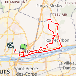
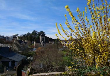
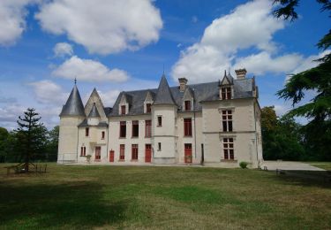
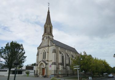
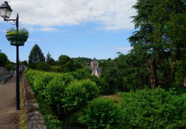
Randonnée Marche de 16,5 km à découvrir à Centre-Val de Loire, Indre-et-Loire, Tours. Cette randonnée est proposée par Daguier.
Description
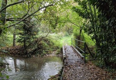
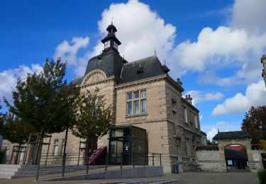
Départ Mairie de Ste Radegonde, direction St Georges, traversée des vignes et descente vers la Loire le long d'un charmant ruisseau (le Bedoire). Retour par le GR3.
Localisation
Pays :
France
Région :
Centre-Val de Loire
Département/Province :
Indre-et-Loire
Commune :
Tours
Localité :
Unknown
Départ:(Dec)
Départ:(UTM)
327295 ; 5252587 (31T) N.
Commentaires
Randonnées à proximité
![Randonnée Marche Tours - Tours - Marmoutier GR3 GR655 Rochecorbon - 8.2km 105m 1h50 - 2021 10 09 - Photo](https://media.geolcdn.com/t/375/260/8eec29df-bf69-4696-8607-c35bff826c99.jpg&format=jpg&maxdim=2)
![Marche Marche](https://static1.geolcdn.com/sitytour/trail-icons/101.png)
Tours - Marmoutier GR3 GR655 Rochecorbon - 8.2km 105m 1h50 - 2021 10 09
Marche
Très facile
(1)
Tours,
Centre-Val de Loire,
Indre-et-Loire,
France
![](/images/other/stat-length.png)
8,2 km | 9,6 km-effort
1h 50min
![](https://static1.geolcdn.com/siteimages/upload/files/16400158638029165_repeat_loop_refresh_sync_direction_icon.png)
Oui
![Randonnée Marche Fondettes - Fondettes Gare - Saint-Cyr-sur-Loire Tours - 23.4km 345m 5h10 (40mn) - 2024 10 27 - Photo](https://media.geolcdn.com/t/375/260/8177205d-60d4-4a9b-baf6-cca40bb2f1c5.jpg&format=jpg&maxdim=2)
![Marche Marche](https://static1.geolcdn.com/sitytour/trail-icons/101.png)
Fondettes Gare - Saint-Cyr-sur-Loire Tours - 23.4km 345m 5h10 (40mn) - 2024 1...
Marche
Facile
Fondettes,
Centre-Val de Loire,
Indre-et-Loire,
France
![](/images/other/stat-length.png)
23 km | 28 km-effort
5h 10min
![](https://static1.geolcdn.com/siteimages/upload/files/16400158638029165_repeat_loop_refresh_sync_direction_icon.png)
Oui
![Randonnée Marche Saint-Cyr-sur-Loire - Saint-Cyr-sur-Loire la Gagnerie - la Membrolle-sur-Choisille Mettray - 24km 405m 5h15 (50mn) - 2024 10 20 - Photo](https://media.geolcdn.com/t/375/260/21cd2b46-14f0-4eaa-a3c8-0e5f8e58cc4a.jpg&format=jpg&maxdim=2)
![Marche Marche](https://static1.geolcdn.com/sitytour/trail-icons/101.png)
Saint-Cyr-sur-Loire la Gagnerie - la Membrolle-sur-Choisille Mettray - 24km 4...
Marche
Moyen
Saint-Cyr-sur-Loire,
Centre-Val de Loire,
Indre-et-Loire,
France
![](/images/other/stat-length.png)
24 km | 29 km-effort
5h 15min
![](https://static1.geolcdn.com/siteimages/upload/files/16400158638029165_repeat_loop_refresh_sync_direction_icon.png)
Oui
![Randonnée Marche Rochecorbon - Rochecorbon - Zig zag autour de Rochecorbon - 17km 295m 3h50 - 2024 03 13 - Photo](https://media.geolcdn.com/t/375/260/c0145acf-b15a-4f41-833a-811e7495297d.jpg&format=jpg&maxdim=2)
![Marche Marche](https://static1.geolcdn.com/sitytour/trail-icons/101.png)
Rochecorbon - Zig zag autour de Rochecorbon - 17km 295m 3h50 - 2024 03 13
Marche
Moyen
Rochecorbon,
Centre-Val de Loire,
Indre-et-Loire,
France
![](/images/other/stat-length.png)
17,1 km | 21 km-effort
3h 50min
![](https://static1.geolcdn.com/siteimages/upload/files/16400158638029165_repeat_loop_refresh_sync_direction_icon.png)
Oui
![Randonnée Marche Saint-Pierre-des-Corps - Saint-Pierre-des-Corps - PR Sentier du bord de Loire avec variantes - 13.6km 75m 2h55 (30mn) - 2023 10 22 - Photo](https://media.geolcdn.com/t/375/260/6a165834-3cba-4860-930a-9c6f29b052c7.jpg&format=jpg&maxdim=2)
![Marche Marche](https://static1.geolcdn.com/sitytour/trail-icons/101.png)
Saint-Pierre-des-Corps - PR Sentier du bord de Loire avec variantes - 13.6km ...
Marche
Facile
Saint-Pierre-des-Corps,
Centre-Val de Loire,
Indre-et-Loire,
France
![](/images/other/stat-length.png)
13,6 km | 14,7 km-effort
2h 55min
![](https://static1.geolcdn.com/siteimages/upload/files/16400158638029165_repeat_loop_refresh_sync_direction_icon.png)
Oui
![Randonnée Marche Parçay-Meslay - Parcay-Meslay - lieu-dit le Houdeau de Monnaie - 21.3km 190m 4h50 (50mn) - 2023 08 27 - Photo](https://media.geolcdn.com/t/375/260/12319d71-2676-4fa6-b6d8-bd3dc55c96dc.jpg&format=jpg&maxdim=2)
![Marche Marche](https://static1.geolcdn.com/sitytour/trail-icons/101.png)
Parcay-Meslay - lieu-dit le Houdeau de Monnaie - 21.3km 190m 4h50 (50mn) - 20...
Marche
Facile
Parçay-Meslay,
Centre-Val de Loire,
Indre-et-Loire,
France
![](/images/other/stat-length.png)
21 km | 24 km-effort
4h 50min
![](https://static1.geolcdn.com/siteimages/upload/files/16400158638029165_repeat_loop_refresh_sync_direction_icon.png)
Oui
![Randonnée Marche Saint-Avertin - Saint-Avertin - PR Sentier du vieux Cher, Cangé - 9.3km 95m 2h05 (20mn) - 2023 07 12 - Photo](https://media.geolcdn.com/t/375/260/1c5742ed-1795-4a54-ac46-a850f2d399d9.jpg&format=jpg&maxdim=2)
![Marche Marche](https://static1.geolcdn.com/sitytour/trail-icons/101.png)
Saint-Avertin - PR Sentier du vieux Cher, Cangé - 9.3km 95m 2h05 (20mn) - 202...
Marche
Facile
Saint-Avertin,
Centre-Val de Loire,
Indre-et-Loire,
France
![](/images/other/stat-length.png)
9,3 km | 10,5 km-effort
2h 5min
![](https://static1.geolcdn.com/siteimages/upload/files/16400158638029165_repeat_loop_refresh_sync_direction_icon.png)
Oui
![Randonnée Marche Tours - Tours - Bd Béranger La Riche - 8.8km 45m 2h00 - 2022 09 12 - Photo](https://media.geolcdn.com/t/375/260/42e96b35-6e0b-4b51-82b8-ef6cff621515.jpg&format=jpg&maxdim=2)
![Marche Marche](https://static1.geolcdn.com/sitytour/trail-icons/101.png)
Tours - Bd Béranger La Riche - 8.8km 45m 2h00 - 2022 09 12
Marche
Très facile
Tours,
Centre-Val de Loire,
Indre-et-Loire,
France
![](/images/other/stat-length.png)
8,8 km | 9,4 km-effort
2h 0min
![](https://static1.geolcdn.com/siteimages/upload/files/16400158638029165_repeat_loop_refresh_sync_direction_icon.png)
Oui
![Randonnée Marche Rochecorbon - Rochecorbon - la Rabatterie Parçay-Meslay - 20.5km 350m 4h45 - 2022 06 12 - Photo](https://media.geolcdn.com/t/375/260/ebc00dba-65ab-4169-97eb-b76e72d9b0a9.jpg&format=jpg&maxdim=2)
![Marche Marche](https://static1.geolcdn.com/sitytour/trail-icons/101.png)
Rochecorbon - la Rabatterie Parçay-Meslay - 20.5km 350m 4h45 - 2022 06 12
Marche
Facile
Rochecorbon,
Centre-Val de Loire,
Indre-et-Loire,
France
![](/images/other/stat-length.png)
21 km | 25 km-effort
4h 45min
![](https://static1.geolcdn.com/siteimages/upload/files/16400158638029165_repeat_loop_refresh_sync_direction_icon.png)
Oui