![](/images/other/stat-length.png)
![Randonnée Marche Les Villedieu - Circuit des Chalets - Photo](https://media.geolcdn.com/t/1900/400/ext.pjpeg?maxdim=2&url=https%3A%2F%2Fstatic1.geolcdn.com%2Fsiteimages%2Fupload%2Ffiles%2F1553511878bg_sport_marche.png)
Circuit des Chalets
micheldutilleul
Utilisateur
![Longueur](/images/other/stat-length.png)
Longueur
10,1 km
![Altitude max](https://static1.geolcdn.com/siteimages/upload/files/1508320355ic_sort_altitude_max_24dp.png)
Altitude max
1179 m
![Dénivelé positif](https://static1.geolcdn.com/siteimages/upload/files/1508320355ic_sort_den_pos_24dp.png)
Dénivelé positif
332 m
![Km-Effort](/images/other/stat-length.png)
Km-Effort
14,5 km
![Altitude min](https://static1.geolcdn.com/siteimages/upload/files/1508320355ic_sort_altitude_min_24dp.png)
Altitude min
923 m
![Dénivelé négatif](https://static1.geolcdn.com/siteimages/upload/files/1508320355ic_sort_den_neg_24dp.png)
Dénivelé négatif
331 m
![Boucle](https://static1.geolcdn.com/siteimages/upload/files/16400158638029165_repeat_loop_refresh_sync_direction_icon.png)
Boucle
Oui
Date de création :
2016-03-30 00:00:00.0
Dernière modification :
2016-03-30 00:00:00.0
![Marche](https://static1.geolcdn.com/sitytour/trail-icons/101.png)
3h03
Difficulté : Moyen
![Scannez ce code QR pour ouvrir la randonnée dans l'application SityTrail](https://capi.geolives.com/qq0zvz2zws4bq2lad0pu/sitytour/trails/546243/qr.png?size=200)
Application GPS de randonnée GRATUITE
À propos
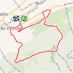
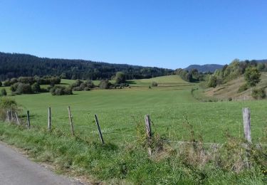
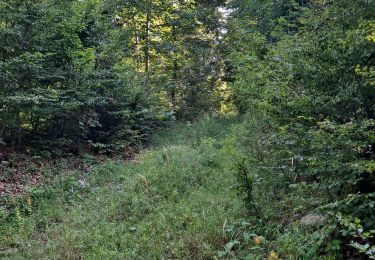
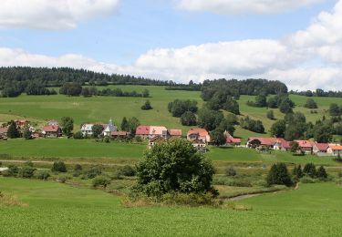
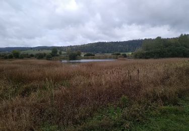
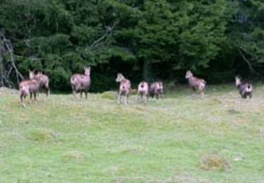
Randonnée Marche de 10,1 km à découvrir à Bourgogne-Franche-Comté, Doubs, Les Villedieu. Cette randonnée est proposée par micheldutilleul.
Description
Val de Mouthe. Départ de Villedieu-les-Mouthe. Découverte de 5 chalets d'alpage. (Randonée 14 www.otmouthe.com)
Localisation
Pays :
France
Région :
Bourgogne-Franche-Comté
Département/Province :
Doubs
Commune :
Les Villedieu
Localité :
Unknown
Départ:(Dec)
Départ:(UTM)
289799 ; 5178771 (32T) N.
Commentaires
Randonnées à proximité
![Randonnée Marche Remoray-Boujeons - Remoray-Boujeons - Le Belvédère des deux Lacs - Photo](https://media.geolcdn.com/t/375/260/2919c784-c06a-4f62-b624-02a232a2dc80.jpg&format=jpg&maxdim=2)
![Marche Marche](https://static1.geolcdn.com/sitytour/trail-icons/101.png)
Remoray-Boujeons - Le Belvédère des deux Lacs
Marche
Difficile
(1)
Remoray-Boujeons,
Bourgogne-Franche-Comté,
Doubs,
France
![](/images/other/stat-length.png)
10,4 km | 13,8 km-effort
2h 58min
![](https://static1.geolcdn.com/siteimages/upload/files/16400158638029165_repeat_loop_refresh_sync_direction_icon.png)
Oui
![Randonnée Marche Remoray-Boujeons - Le Belvédère des 2 lacs - Doubs - Photo](https://media.geolcdn.com/t/375/260/ext.jpg?maxdim=2&url=https%3A%2F%2Fservices.sitytrail.com%2FGeolivesWS%2FDownloadMedia.ashx%3FTrailID%3D108936%26Media%3D2627_1.jpg)
![Marche Marche](https://static1.geolcdn.com/sitytour/trail-icons/101.png)
Le Belvédère des 2 lacs - Doubs
Marche
Difficile
(1)
Remoray-Boujeons,
Bourgogne-Franche-Comté,
Doubs,
France
![](/images/other/stat-length.png)
13,7 km | 19 km-effort
4h 0min
![](https://static1.geolcdn.com/siteimages/upload/files/16400158638029165_repeat_loop_refresh_sync_direction_icon.png)
Oui
![Randonnée Marche Mouthe - Mouthe - La Source du Doubs - Photo](https://media.geolcdn.com/t/375/260/ext.jpg?maxdim=2&url=https%3A%2F%2Fstatic1.geolcdn.com%2Fsiteimages%2Fupload%2Ffiles%2F1553511878bg_sport_marche.png)
![Marche Marche](https://static1.geolcdn.com/sitytour/trail-icons/101.png)
Mouthe - La Source du Doubs
Marche
Très facile
(1)
Mouthe,
Bourgogne-Franche-Comté,
Doubs,
France
![](/images/other/stat-length.png)
5,4 km | 6,5 km-effort
Inconnu
![](https://static1.geolcdn.com/siteimages/upload/files/16400158638029165_repeat_loop_refresh_sync_direction_icon.png)
Oui
![Randonnée Marche Remoray-Boujeons - Boucle autour de la baume champion - Photo](https://media.geolcdn.com/t/375/260/3a442925-66e1-4cbd-a363-dafd1213bd4b.jpg&format=jpg&maxdim=2)
![Marche Marche](https://static1.geolcdn.com/sitytour/trail-icons/101.png)
Boucle autour de la baume champion
Marche
Moyen
Remoray-Boujeons,
Bourgogne-Franche-Comté,
Doubs,
France
![](/images/other/stat-length.png)
8,5 km | 10,9 km-effort
2h 28min
![](https://static1.geolcdn.com/siteimages/upload/files/16400158638029165_repeat_loop_refresh_sync_direction_icon.png)
Oui
![Randonnée A pied Rondefontaine - Le Rivier - Photo](https://media.geolcdn.com/t/375/260/e94bce2a-8351-4e98-9976-83c866947762.jpeg&format=jpg&maxdim=2)
![A pied A pied](https://static1.geolcdn.com/sitytour/trail-icons/100.png)
Le Rivier
A pied
Facile
Rondefontaine,
Bourgogne-Franche-Comté,
Doubs,
France
![](/images/other/stat-length.png)
9,5 km | 12,5 km-effort
2h 51min
![](https://static1.geolcdn.com/siteimages/upload/files/16400158638029165_repeat_loop_refresh_sync_direction_icon.png)
Oui
![Randonnée Marche Labergement-Sainte-Marie - Lac de Remoray - Photo](https://media.geolcdn.com/t/375/260/ee62ae3a-7d82-4bd9-a18a-0063a4ffda31.jpg&format=jpg&maxdim=2)
![Marche Marche](https://static1.geolcdn.com/sitytour/trail-icons/101.png)
Lac de Remoray
Marche
Facile
Labergement-Sainte-Marie,
Bourgogne-Franche-Comté,
Doubs,
France
![](/images/other/stat-length.png)
14,5 km | 18,4 km-effort
3h 25min
![](https://static1.geolcdn.com/siteimages/upload/files/16400158638029165_repeat_loop_refresh_sync_direction_icon.png)
Non
![Randonnée Marche Remoray-Boujeons - REMORAY - au-dessus du village - Photo](https://media.geolcdn.com/t/375/260/ext.jpg?maxdim=2&url=https%3A%2F%2Fstatic1.geolcdn.com%2Fsiteimages%2Fupload%2Ffiles%2F1553511878bg_sport_marche.png)
![Marche Marche](https://static1.geolcdn.com/sitytour/trail-icons/101.png)
REMORAY - au-dessus du village
Marche
Moyen
(1)
Remoray-Boujeons,
Bourgogne-Franche-Comté,
Doubs,
France
![](/images/other/stat-length.png)
8,6 km | 11,7 km-effort
2h 28min
![](https://static1.geolcdn.com/siteimages/upload/files/16400158638029165_repeat_loop_refresh_sync_direction_icon.png)
Oui
![Randonnée V.T.T. Labergement-Sainte-Marie - Mont d'Or par les gorges du Fourperet - Franche-Comté, France - Photo](https://media.geolcdn.com/t/375/260/ext.jpg?maxdim=2&url=https%3A%2F%2Fservices.sitytrail.com%2FGeolivesWS%2FDownloadMedia.ashx%3FTrailID%3D105601%26Media%3D9367_4.jpg)
![V.T.T. V.T.T.](https://static1.geolcdn.com/sitytour/trail-icons/202.png)
Mont d'Or par les gorges du Fourperet - Franche-Comté, France
V.T.T.
Difficile
Labergement-Sainte-Marie,
Bourgogne-Franche-Comté,
Doubs,
France
![](/images/other/stat-length.png)
23 km | 33 km-effort
4h 0min
![](https://static1.geolcdn.com/siteimages/upload/files/16400158638029165_repeat_loop_refresh_sync_direction_icon.png)
Oui
![Randonnée Marche Labergement-Sainte-Marie - Mont d'Or par les gorges du Fourperet - Franche-Comté, France - Photo](https://media.geolcdn.com/t/375/260/ext.jpg?maxdim=2&url=https%3A%2F%2Fservices.sitytrail.com%2FGeolivesWS%2FDownloadMedia.ashx%3FTrailID%3D105600%26Media%3D9367_4.jpg)
![Marche Marche](https://static1.geolcdn.com/sitytour/trail-icons/101.png)
Mont d'Or par les gorges du Fourperet - Franche-Comté, France
Marche
Moyen
Labergement-Sainte-Marie,
Bourgogne-Franche-Comté,
Doubs,
France
![](/images/other/stat-length.png)
23 km | 33 km-effort
5h 0min
![](https://static1.geolcdn.com/siteimages/upload/files/16400158638029165_repeat_loop_refresh_sync_direction_icon.png)
Oui