![](/images/other/stat-length.png)
RF-Na-11-Neptune_Grande-boucle
GR Rando
Randonnez sur et autour des GR ® wallons (Sentiers de Grande Randonnée). PRO
![Longueur](/images/other/stat-length.png)
![Altitude max](https://static1.geolcdn.com/siteimages/upload/files/1508320355ic_sort_altitude_max_24dp.png)
![Dénivelé positif](https://static1.geolcdn.com/siteimages/upload/files/1508320355ic_sort_den_pos_24dp.png)
![Km-Effort](/images/other/stat-length.png)
![Altitude min](https://static1.geolcdn.com/siteimages/upload/files/1508320355ic_sort_altitude_min_24dp.png)
![Dénivelé négatif](https://static1.geolcdn.com/siteimages/upload/files/1508320355ic_sort_den_neg_24dp.png)
![Boucle](https://static1.geolcdn.com/siteimages/upload/files/16400158638029165_repeat_loop_refresh_sync_direction_icon.png)
![Marche](https://static1.geolcdn.com/sitytour/trail-icons/101.png)
2h43
Difficulté : Moyen
![Scannez ce code QR pour ouvrir la randonnée dans l'application SityTrail](https://capi.geolives.com/qq0zvz2zws4bq2lad0pu/sitytour/trails/545772/qr.png?size=200)
Application GPS de randonnée GRATUITE
À propos
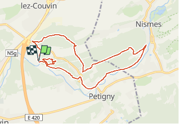
Randonnée Marche de 9,1 km à découvrir à Wallonie, Namur, Couvin. Cette randonnée est proposée par GR Rando.
Description
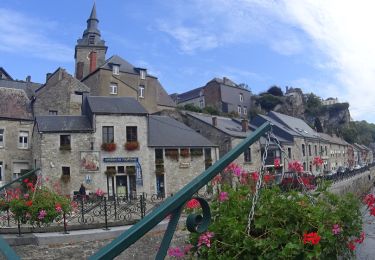
Neptune jaillit des eaux vives de l’Eau Noire
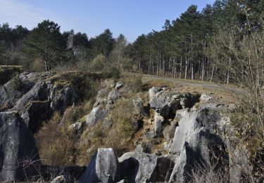
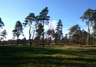
Dans quel type de paysage notre famille randonne-t-elle ?
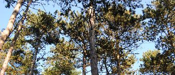
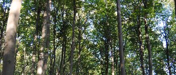
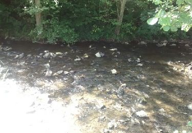
La plupart du temps, notre famille Rando est au cœur de la forêt. Dans les portions où la vue se dégage, les bois sont toujours proches. Ici et là, les randonneurs profitent des charmes de l’Eau Noire. Quand la famille s’éloigne un peu pour aller au Tienne du Lion, elle bénéficie d’un panorama remarquable sur la vallée de l’Eau Noire et les villages de Frasnes et de Mariembourg.
Quelle difficulté pour notre famille Rando?
Elle ne rencontre pas de difficulté particulière. On peut donc qualifier cette randonnée de facile.
Combien de kilomètres ?
10,8 km pour la grande boucle.
Sur quel GR randonne-t-elle ?
La famille Rando emprunte un tronçon du GR 125 « Tour de l’Entre-Sambre-et-Meuse ».
Où démarre-t-elle ?
Du parking des grottes de Neptune.
Comment y arrive-t-elle ?
Par la N5 Charleroi - Couvin, sortir à Frasnes et suivre les indications « Grotte de Neptune ».
Que découvre-t-elle aujourd’hui ?
Après un parcours en surface, c’est maintenant le sous-sol que notre famille Rando explore.
Quelle est la carte IGN de référence ?
Cartes IGN au 1:20 000, 57/7-8 « Chimay – Couvin » et 58/5-6 « Viroinval ».
Localisation
Commentaires
Randonnées à proximité
![Randonnée Marche Couvin - Randonnée géologique - Photo](https://media.geolcdn.com/t/375/260/ext.jpg?maxdim=2&url=https%3A%2F%2Fservices.sitytrail.com%2FGeolivesWS%2FDownloadMedia.ashx%3FTrailID%3D535563%26Media%3D1ffcf5ce-1a74-4050-b18b-23e492a14ad7.jpg)
![Marche Marche](https://static1.geolcdn.com/sitytour/trail-icons/101.png)
Marche
![](/images/other/stat-length.png)
![](https://static1.geolcdn.com/siteimages/upload/files/16400158638029165_repeat_loop_refresh_sync_direction_icon.png)
![Randonnée Marche Viroinval - RB-Na-13_Nismes - Photo](https://media.geolcdn.com/t/375/260/ext.jpg?maxdim=2&url=https%3A%2F%2Fservices.sitytrail.com%2FGeolivesWS%2FDownloadMedia.ashx%3FTrailID%3D260747%26Media%3Dff8837a8-8f2b-4db1-ba1e-88015d1f5e8a.jpg)
![Marche Marche](https://static1.geolcdn.com/sitytour/trail-icons/101.png)
Marche
![](/images/other/stat-length.png)
![](https://static1.geolcdn.com/siteimages/upload/files/16400158638029165_repeat_loop_refresh_sync_direction_icon.png)
![Randonnée Marche Couvin - Promenade de la Justice et du centre de Couvin - Photo](https://media.geolcdn.com/t/375/260/ext.jpg?maxdim=2&url=https%3A%2F%2Fservices.sitytrail.com%2FGeolivesWS%2FDownloadMedia.ashx%3FTrailID%3D847004%26Media%3Ddb58757b-04f6-43c3-88ea-5884e299364a.JPG)
![Marche Marche](https://static1.geolcdn.com/sitytour/trail-icons/101.png)
Marche
![](/images/other/stat-length.png)
![](https://static1.geolcdn.com/siteimages/upload/files/16400158638029165_repeat_loop_refresh_sync_direction_icon.png)
![Randonnée Vélo Viroinval - À la découverte de Viroinval - Photo](https://media.geolcdn.com/t/375/260/ext.jpg?maxdim=2&url=https%3A%2F%2Fservices.sitytrail.com%2FGeolivesWS%2FDownloadMedia.ashx%3FTrailID%3D551547%26Media%3D1e3b4634-36c4-481a-a49d-2f3fedd5bc9a.JPG)
![Vélo Vélo](https://static1.geolcdn.com/sitytour/trail-icons/200.png)
Vélo
![](/images/other/stat-length.png)
![](https://static1.geolcdn.com/siteimages/upload/files/16400158638029165_repeat_loop_refresh_sync_direction_icon.png)
![Randonnée Marche Couvin - (Couvin) 22 Promenade de l'Eau Noire - Photo](https://media.geolcdn.com/t/375/260/ext.jpg?maxdim=2&url=https%3A%2F%2Fstatic1.geolcdn.com%2Fsiteimages%2Fupload%2Ffiles%2F1553511878bg_sport_marche.png)
![Marche Marche](https://static1.geolcdn.com/sitytour/trail-icons/101.png)
Marche
![](/images/other/stat-length.png)
![](https://static1.geolcdn.com/siteimages/upload/files/16400158638029165_repeat_loop_refresh_sync_direction_icon.png)
![Randonnée Marche Couvin - couvin - Au long de l'eau noire - Photo](https://media.geolcdn.com/t/375/260/ext.jpg?maxdim=2&url=https%3A%2F%2Fservices.sitytrail.com%2FGeolivesWS%2FDownloadMedia.ashx%3FTrailID%3D809615%26Media%3Dfix__20170814160157.jpg)
![Marche Marche](https://static1.geolcdn.com/sitytour/trail-icons/101.png)
Marche
![](/images/other/stat-length.png)
![](https://static1.geolcdn.com/siteimages/upload/files/16400158638029165_repeat_loop_refresh_sync_direction_icon.png)
![Randonnée Marche Viroinval - fondry des chiens - Photo](https://media.geolcdn.com/t/375/260/ext.jpg?maxdim=2&url=https%3A%2F%2Fservices.sitytrail.com%2FGeolivesWS%2FDownloadMedia.ashx%3FTrailID%3D629836%26Media%3Dfix__20160911163715.jpg)
![Marche Marche](https://static1.geolcdn.com/sitytour/trail-icons/101.png)
Marche
![](/images/other/stat-length.png)
![](https://static1.geolcdn.com/siteimages/upload/files/16400158638029165_repeat_loop_refresh_sync_direction_icon.png)
![Randonnée Marche Couvin - RF-Na-11-Neptune_Petite-boucle - Photo](https://media.geolcdn.com/t/375/260/ext.jpg?maxdim=2&url=https%3A%2F%2Fservices.sitytrail.com%2FGeolivesWS%2FDownloadMedia.ashx%3FTrailID%3D545771%26Media%3Dceaef66d-674f-485f-bb67-ca6ebb407dac.JPG)
![Marche Marche](https://static1.geolcdn.com/sitytour/trail-icons/101.png)
Marche
![](/images/other/stat-length.png)
![](https://static1.geolcdn.com/siteimages/upload/files/16400158638029165_repeat_loop_refresh_sync_direction_icon.png)
![Randonnée Marche nordique Viroinval - VNW - Nismes - 3 - Les Abannets - Photo](https://media.geolcdn.com/t/375/260/ext.jpg?maxdim=2&url=https%3A%2F%2Fservices.sitytrail.com%2FGeolivesWS%2FDownloadMedia.ashx%3FTrailID%3D506304%26Media%3D592984e1-2b1c-46a5-83a7-3cffd93c8cd6.jpg)
![Marche nordique Marche nordique](https://static1.geolcdn.com/sitytour/trail-icons/102.png)
Marche nordique
![](/images/other/stat-length.png)
![](https://static1.geolcdn.com/siteimages/upload/files/16400158638029165_repeat_loop_refresh_sync_direction_icon.png)
Pour l'instant,juste une prise en main.Vraiment simple et prometteur, à voir sur le terrain.