![](/images/other/stat-length.png)
![Randonnée Marche Fougères - Le Fougères des Chouans - Photo](https://media.geolcdn.com/t/1900/400/ext.pjpeg?maxdim=2&url=https%3A%2F%2Fstatic1.geolcdn.com%2Fsiteimages%2Fupload%2Ffiles%2F1553511878bg_sport_marche.png)
Le Fougères des Chouans
neoroll44
Utilisateur
![Longueur](/images/other/stat-length.png)
Longueur
15 km
![Altitude max](https://static1.geolcdn.com/siteimages/upload/files/1508320355ic_sort_altitude_max_24dp.png)
Altitude max
192 m
![Dénivelé positif](https://static1.geolcdn.com/siteimages/upload/files/1508320355ic_sort_den_pos_24dp.png)
Dénivelé positif
282 m
![Km-Effort](/images/other/stat-length.png)
Km-Effort
18,7 km
![Altitude min](https://static1.geolcdn.com/siteimages/upload/files/1508320355ic_sort_altitude_min_24dp.png)
Altitude min
88 m
![Dénivelé négatif](https://static1.geolcdn.com/siteimages/upload/files/1508320355ic_sort_den_neg_24dp.png)
Dénivelé négatif
281 m
![Boucle](https://static1.geolcdn.com/siteimages/upload/files/16400158638029165_repeat_loop_refresh_sync_direction_icon.png)
Boucle
Oui
Date de création :
2016-03-23 00:00:00.0
Dernière modification :
2016-03-23 00:00:00.0
![Marche](https://static1.geolcdn.com/sitytour/trail-icons/101.png)
4h02
Difficulté : Moyen
![Scannez ce code QR pour ouvrir la randonnée dans l'application SityTrail](https://capi.geolives.com/qq0zvz2zws4bq2lad0pu/sitytour/trails/542320/qr.png?size=200)
Application GPS de randonnée GRATUITE
À propos
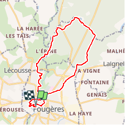
Randonnée Marche de 15 km à découvrir à Bretagne, Ille-et-Vilaine, Fougères. Cette randonnée est proposée par neoroll44.
Description
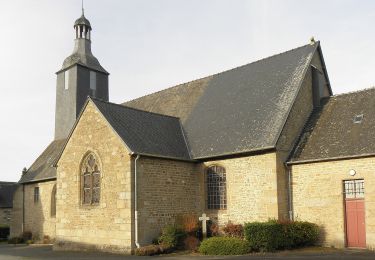
De l'église St-Léonard, St-Sulpice, le château et la forêt de Fougères.
Localisation
Pays :
France
Région :
Bretagne
Département/Province :
Ille-et-Vilaine
Commune :
Fougères
Localité :
Unknown
Départ:(Dec)
Départ:(UTM)
633014 ; 5356954 (30U) N.
Commentaires
Randonnées à proximité
![Randonnée A pied Landéan - Les Vieux Châteaux - Photo](https://media.geolcdn.com/t/375/260/122c427c-456b-4f47-979b-0a8d83dc03ab.jpeg&format=jpg&maxdim=2)
![A pied A pied](https://static1.geolcdn.com/sitytour/trail-icons/100.png)
Les Vieux Châteaux
A pied
Facile
(1)
Landéan,
Bretagne,
Ille-et-Vilaine,
France
![](/images/other/stat-length.png)
5,3 km | 6,3 km-effort
1h 26min
![](https://static1.geolcdn.com/siteimages/upload/files/16400158638029165_repeat_loop_refresh_sync_direction_icon.png)
Oui
![Randonnée A pied Landéan - La Longue Noë - Photo](https://media.geolcdn.com/t/375/260/f327ed77-355c-4519-bce4-a684f55ad906.jpeg&format=jpg&maxdim=2)
![A pied A pied](https://static1.geolcdn.com/sitytour/trail-icons/100.png)
La Longue Noë
A pied
Facile
Landéan,
Bretagne,
Ille-et-Vilaine,
France
![](/images/other/stat-length.png)
6,2 km | 7,4 km-effort
1h 41min
![](https://static1.geolcdn.com/siteimages/upload/files/16400158638029165_repeat_loop_refresh_sync_direction_icon.png)
Oui
![Randonnée Marche nordique Landéan - Poulailler autour du Moulin d'Avion 12,5km - Photo](https://media.geolcdn.com/t/375/260/ext.jpg?maxdim=2&url=https%3A%2F%2Fservices.sitytrail.com%2FGeolivesWS%2FDownloadMedia.ashx%3FTrailID%3D676451%26Media%3Dcc3eee66-6e8e-4acd-8735-e9a30f06fcf1.jpeg)
![Marche nordique Marche nordique](https://static1.geolcdn.com/sitytour/trail-icons/102.png)
Poulailler autour du Moulin d'Avion 12,5km
Marche nordique
Moyen
Landéan,
Bretagne,
Ille-et-Vilaine,
France
![](/images/other/stat-length.png)
12,5 km | 14,9 km-effort
2h 10min
![](https://static1.geolcdn.com/siteimages/upload/files/16400158638029165_repeat_loop_refresh_sync_direction_icon.png)
Oui
![Randonnée Marche nordique Landéan - Poulailler Chénedet 10,4km - Photo](https://media.geolcdn.com/t/375/260/ext.jpg?maxdim=2&url=https%3A%2F%2Fservices.sitytrail.com%2FGeolivesWS%2FDownloadMedia.ashx%3FTrailID%3D676433%26Media%3Dc418e412-7874-4576-9726-02eef27b2c32.jpg)
![Marche nordique Marche nordique](https://static1.geolcdn.com/sitytour/trail-icons/102.png)
Poulailler Chénedet 10,4km
Marche nordique
Moyen
Landéan,
Bretagne,
Ille-et-Vilaine,
France
![](/images/other/stat-length.png)
10,3 km | 12,5 km-effort
2h 50min
![](https://static1.geolcdn.com/siteimages/upload/files/16400158638029165_repeat_loop_refresh_sync_direction_icon.png)
Oui
![Randonnée Marche nordique Landéan - CMN Albert 10km - Photo](https://media.geolcdn.com/t/375/260/ext.jpg?maxdim=2&url=https%3A%2F%2Fservices.sitytrail.com%2FGeolivesWS%2FDownloadMedia.ashx%3FTrailID%3D189602%26Media%3D27502648-31d9-4ef3-b6ad-5dd7e3ce8752.jpg)
![Marche nordique Marche nordique](https://static1.geolcdn.com/sitytour/trail-icons/102.png)
CMN Albert 10km
Marche nordique
Moyen
Landéan,
Bretagne,
Ille-et-Vilaine,
France
![](/images/other/stat-length.png)
9,9 km | 12 km-effort
1h 40min
![](https://static1.geolcdn.com/siteimages/upload/files/16400158638029165_repeat_loop_refresh_sync_direction_icon.png)
Oui
![Randonnée Marche nordique Landéan - CMN Françoise 10 - Photo](https://media.geolcdn.com/t/375/260/ext.jpg?maxdim=2&url=https%3A%2F%2Fservices.sitytrail.com%2FGeolivesWS%2FDownloadMedia.ashx%3FTrailID%3D188449%26Media%3D09b0d8a3-5ae2-461c-ad1f-fb0e22cf207f.jpg)
![Marche nordique Marche nordique](https://static1.geolcdn.com/sitytour/trail-icons/102.png)
CMN Françoise 10
Marche nordique
Moyen
Landéan,
Bretagne,
Ille-et-Vilaine,
France
![](/images/other/stat-length.png)
10,5 km | 12,5 km-effort
1h 50min
![](https://static1.geolcdn.com/siteimages/upload/files/16400158638029165_repeat_loop_refresh_sync_direction_icon.png)
Oui
![Randonnée Marche nordique Landéan - Léandre - Photo](https://media.geolcdn.com/t/375/260/ext.jpg?maxdim=2&url=https%3A%2F%2Fservices.sitytrail.com%2FGeolivesWS%2FDownloadMedia.ashx%3FTrailID%3D187651%26Media%3D263e6600-ee89-4974-b42c-0cf56a92d847.jpg)
![Marche nordique Marche nordique](https://static1.geolcdn.com/sitytour/trail-icons/102.png)
Léandre
Marche nordique
Moyen
Landéan,
Bretagne,
Ille-et-Vilaine,
France
![](/images/other/stat-length.png)
12,4 km | 14,9 km-effort
2h 20min
![](https://static1.geolcdn.com/siteimages/upload/files/16400158638029165_repeat_loop_refresh_sync_direction_icon.png)
Oui
![Randonnée Marche nordique Landéan - CMN Du Poulailler dans la ville 15 km - Photo](https://media.geolcdn.com/t/375/260/ext.jpg?maxdim=2&url=https%3A%2F%2Fservices.sitytrail.com%2FGeolivesWS%2FDownloadMedia.ashx%3FTrailID%3D162112%26Media%3D9e9344dd-ab74-44da-9479-e497c8838235.jpeg)
![Marche nordique Marche nordique](https://static1.geolcdn.com/sitytour/trail-icons/102.png)
CMN Du Poulailler dans la ville 15 km
Marche nordique
Moyen
Landéan,
Bretagne,
Ille-et-Vilaine,
France
![](/images/other/stat-length.png)
14,9 km | 18 km-effort
2h 50min
![](https://static1.geolcdn.com/siteimages/upload/files/16400158638029165_repeat_loop_refresh_sync_direction_icon.png)
Oui
![Randonnée Marche nordique Landéan - Poulailler à Galoupel 11,6km - Photo](https://media.geolcdn.com/t/375/260/ext.jpg?maxdim=2&url=https%3A%2F%2Fservices.sitytrail.com%2FGeolivesWS%2FDownloadMedia.ashx%3FTrailID%3D162110%26Media%3D413a32e4-2e2a-44c9-a005-215b3d70b193.jpg)
![Marche nordique Marche nordique](https://static1.geolcdn.com/sitytour/trail-icons/102.png)
Poulailler à Galoupel 11,6km
Marche nordique
Moyen
Landéan,
Bretagne,
Ille-et-Vilaine,
France
![](/images/other/stat-length.png)
11,5 km | 13,9 km-effort
2h 10min
![](https://static1.geolcdn.com/siteimages/upload/files/16400158638029165_repeat_loop_refresh_sync_direction_icon.png)
Oui