![](/images/other/stat-length.png)
![Randonnée Marche Salles - Les Forges - Photo](https://media.geolcdn.com/t/1900/400/ext.pjpeg?maxdim=2&url=https%3A%2F%2Fstatic1.geolcdn.com%2Fsiteimages%2Fupload%2Ffiles%2F1553511878bg_sport_marche.png)
Les Forges
plavengut
Utilisateur
![Longueur](/images/other/stat-length.png)
Longueur
6,2 km
![Altitude max](https://static1.geolcdn.com/siteimages/upload/files/1508320355ic_sort_altitude_max_24dp.png)
Altitude max
39 m
![Dénivelé positif](https://static1.geolcdn.com/siteimages/upload/files/1508320355ic_sort_den_pos_24dp.png)
Dénivelé positif
48 m
![Km-Effort](/images/other/stat-length.png)
Km-Effort
6,8 km
![Altitude min](https://static1.geolcdn.com/siteimages/upload/files/1508320355ic_sort_altitude_min_24dp.png)
Altitude min
23 m
![Dénivelé négatif](https://static1.geolcdn.com/siteimages/upload/files/1508320355ic_sort_den_neg_24dp.png)
Dénivelé négatif
48 m
![Boucle](https://static1.geolcdn.com/siteimages/upload/files/16400158638029165_repeat_loop_refresh_sync_direction_icon.png)
Boucle
Oui
Date de création :
2016-03-22 00:00:00.0
Dernière modification :
2016-03-22 00:00:00.0
![Marche](https://static1.geolcdn.com/sitytour/trail-icons/101.png)
1h21
Difficulté : Facile
![Scannez ce code QR pour ouvrir la randonnée dans l'application SityTrail](https://capi.geolives.com/qq0zvz2zws4bq2lad0pu/sitytour/trails/542054/qr.png?size=200)
Application GPS de randonnée GRATUITE
À propos
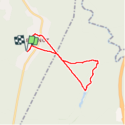
Randonnée Marche de 6,2 km à découvrir à Nouvelle-Aquitaine, Gironde, Salles. Cette randonnée est proposée par plavengut.
Description
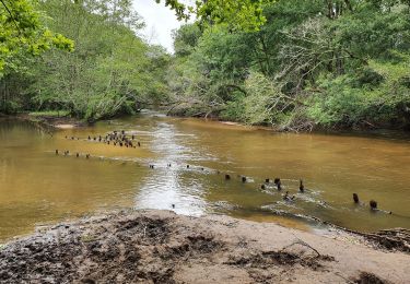
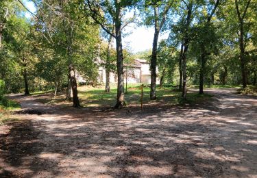
Parcours depuis les chambres d hôtes du l'anot, dans la forêt et le long d un ruisseau. Pour les adeptes du géo coaching, se parcours permet d effectuer la geocache des forges. Parcours pédestre ou à VTT
Localisation
Pays :
France
Région :
Nouvelle-Aquitaine
Département/Province :
Gironde
Commune :
Salles
Localité :
Unknown
Départ:(Dec)
Départ:(UTM)
668862 ; 4931499 (30T) N.
Commentaires
Randonnées à proximité
![Randonnée Marche Salles - Lanot, moulin de Moulon, Bilos - Photo](https://media.geolcdn.com/t/375/260/ext.jpg?maxdim=2&url=https%3A%2F%2Fstatic1.geolcdn.com%2Fsiteimages%2Fupload%2Ffiles%2F1553511878bg_sport_marche.png)
![Marche Marche](https://static1.geolcdn.com/sitytour/trail-icons/101.png)
Lanot, moulin de Moulon, Bilos
Marche
Très facile
(1)
Salles,
Nouvelle-Aquitaine,
Gironde,
France
![](/images/other/stat-length.png)
9,8 km | 11 km-effort
2h 50min
![](https://static1.geolcdn.com/siteimages/upload/files/16400158638029165_repeat_loop_refresh_sync_direction_icon.png)
Oui
![Randonnée sport Salles - Boucle route de la mole - Photo](https://media.geolcdn.com/t/375/260/ext.jpg?maxdim=2&url=https%3A%2F%2Fsecurestorage.geolives.com%2Fsitytour%2Ftrail-bg%2Fdefault.jpg)
Boucle route de la mole
sport
Très facile
(1)
Salles,
Nouvelle-Aquitaine,
Gironde,
France
![](/images/other/stat-length.png)
9,6 km | 10,5 km-effort
Inconnu
![](https://static1.geolcdn.com/siteimages/upload/files/16400158638029165_repeat_loop_refresh_sync_direction_icon.png)
Oui
![Randonnée V.T.C. Salles - Salles - De Salles à Belin-Béliet - Photo](https://media.geolcdn.com/t/375/260/01172f9e-c0a9-41f7-a2dd-20f5fb1b7995.jpg&format=jpg&maxdim=2)
![V.T.C. V.T.C.](https://static1.geolcdn.com/sitytour/trail-icons/203.png)
Salles - De Salles à Belin-Béliet
V.T.C.
Moyen
Salles,
Nouvelle-Aquitaine,
Gironde,
France
![](/images/other/stat-length.png)
19,4 km | 22 km-effort
2h 13min
![](https://static1.geolcdn.com/siteimages/upload/files/16400158638029165_repeat_loop_refresh_sync_direction_icon.png)
Non
![Randonnée Marche Salles - jour 1 - Photo](https://media.geolcdn.com/t/375/260/ext.jpg?maxdim=2&url=https%3A%2F%2Fstatic1.geolcdn.com%2Fsiteimages%2Fupload%2Ffiles%2F1553511878bg_sport_marche.png)
![Marche Marche](https://static1.geolcdn.com/sitytour/trail-icons/101.png)
jour 1
Marche
Très facile
(1)
Salles,
Nouvelle-Aquitaine,
Gironde,
France
![](/images/other/stat-length.png)
7,3 km | 8,1 km-effort
1h 32min
![](https://static1.geolcdn.com/siteimages/upload/files/16400158638029165_repeat_loop_refresh_sync_direction_icon.png)
Non
![Randonnée Marche Salles - j11 - Photo](https://media.geolcdn.com/t/375/260/ext.jpg?maxdim=2&url=https%3A%2F%2Fstatic1.geolcdn.com%2Fsiteimages%2Fupload%2Ffiles%2F1553511878bg_sport_marche.png)
![Marche Marche](https://static1.geolcdn.com/sitytour/trail-icons/101.png)
j11
Marche
Très facile
(1)
Salles,
Nouvelle-Aquitaine,
Gironde,
France
![](/images/other/stat-length.png)
6,3 km | 6,9 km-effort
1h 19min
![](https://static1.geolcdn.com/siteimages/upload/files/16400158638029165_repeat_loop_refresh_sync_direction_icon.png)
Oui
![Randonnée Marche Lugos - chapelle Saint Lugo - Photo](https://media.geolcdn.com/t/375/260/c0e66ab5-f691-4664-b528-db5f3cb32f16.jpg&format=jpg&maxdim=2)
![Marche Marche](https://static1.geolcdn.com/sitytour/trail-icons/101.png)
chapelle Saint Lugo
Marche
Difficile
Lugos,
Nouvelle-Aquitaine,
Gironde,
France
![](/images/other/stat-length.png)
12,1 km | 13,6 km-effort
3h 50min
![](https://static1.geolcdn.com/siteimages/upload/files/16400158638029165_repeat_loop_refresh_sync_direction_icon.png)
Oui
![Randonnée Marche Lugos - lugo - Photo](https://media.geolcdn.com/t/375/260/4e11623e-9d6c-4953-95d4-4ca70e7d8e3a.jpg&format=jpg&maxdim=2)
![Marche Marche](https://static1.geolcdn.com/sitytour/trail-icons/101.png)
lugo
Marche
Très facile
Lugos,
Nouvelle-Aquitaine,
Gironde,
France
![](/images/other/stat-length.png)
10,9 km | 12,2 km-effort
2h 21min
![](https://static1.geolcdn.com/siteimages/upload/files/16400158638029165_repeat_loop_refresh_sync_direction_icon.png)
Oui
![Randonnée Vélo électrique Salles - moto sillac - Photo](https://media.geolcdn.com/t/375/260/ext.jpg?maxdim=2&url=https%3A%2F%2Fstatic1.geolcdn.com%2Fsiteimages%2Fupload%2Ffiles%2F1524743154velo.jpg)
![Vélo électrique Vélo électrique](https://static1.geolcdn.com/sitytour/trail-icons/205.png)
moto sillac
Vélo électrique
Très facile
Salles,
Nouvelle-Aquitaine,
Gironde,
France
![](/images/other/stat-length.png)
29 km | 32 km-effort
1h 33min
![](https://static1.geolcdn.com/siteimages/upload/files/16400158638029165_repeat_loop_refresh_sync_direction_icon.png)
Non
![Randonnée Marche Lugos - Bran Vieux Lugo - Photo](https://media.geolcdn.com/t/375/260/ext.jpg?maxdim=2&url=https%3A%2F%2Fstatic1.geolcdn.com%2Fsiteimages%2Fupload%2Ffiles%2F1553511878bg_sport_marche.png)
![Marche Marche](https://static1.geolcdn.com/sitytour/trail-icons/101.png)
Bran Vieux Lugo
Marche
Moyen
Lugos,
Nouvelle-Aquitaine,
Gironde,
France
![](/images/other/stat-length.png)
10,4 km | 12 km-effort
3h 0min
![](https://static1.geolcdn.com/siteimages/upload/files/16400158638029165_repeat_loop_refresh_sync_direction_icon.png)
Oui