![](/images/other/stat-length.png)
Nanteuil_Condac
neoroll44
Utilisateur
![Longueur](/images/other/stat-length.png)
Longueur
26 km
![Altitude max](https://static1.geolcdn.com/siteimages/upload/files/1508320355ic_sort_altitude_max_24dp.png)
Altitude max
171 m
![Dénivelé positif](https://static1.geolcdn.com/siteimages/upload/files/1508320355ic_sort_den_pos_24dp.png)
Dénivelé positif
351 m
![Km-Effort](/images/other/stat-length.png)
Km-Effort
31 km
![Altitude min](https://static1.geolcdn.com/siteimages/upload/files/1508320355ic_sort_altitude_min_24dp.png)
Altitude min
75 m
![Dénivelé négatif](https://static1.geolcdn.com/siteimages/upload/files/1508320355ic_sort_den_neg_24dp.png)
Dénivelé négatif
352 m
![Boucle](https://static1.geolcdn.com/siteimages/upload/files/16400158638029165_repeat_loop_refresh_sync_direction_icon.png)
Boucle
Oui
Date de création :
2016-04-16 00:00:00.0
Dernière modification :
2016-04-16 00:00:00.0
![Marche](https://static1.geolcdn.com/sitytour/trail-icons/101.png)
7h00
Difficulté : Moyen
![Scannez ce code QR pour ouvrir la randonnée dans l'application SityTrail](https://capi.geolives.com/qq0zvz2zws4bq2lad0pu/sitytour/trails/541902/qr.png?size=200)
Application GPS de randonnée GRATUITE
À propos
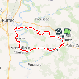
Randonnée Marche de 26 km à découvrir à Nouvelle-Aquitaine, Charente, Nanteuil-en-Vallée. Cette randonnée est proposée par neoroll44.
Description
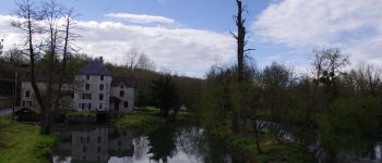
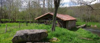
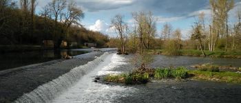
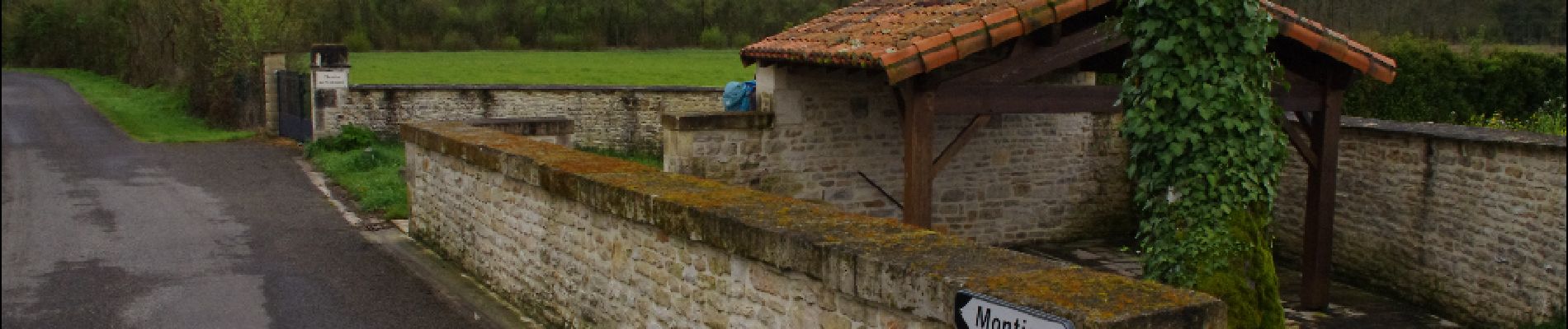
Par Verteuil, la base nautique de Rejallant (aire de détente, restaurant, pique-nique, canoë, camping), les rives de la Charente et les bois.
Localisation
Pays :
France
Région :
Nouvelle-Aquitaine
Département/Province :
Charente
Commune :
Nanteuil-en-Vallée
Localité :
Nanteuil-en-Vallée
Départ:(Dec)
Départ:(UTM)
292676 ; 5097582 (31T) N.
Commentaires
Randonnées à proximité
![Randonnée V.T.T. Nanteuil-en-Vallée - Nanteuil en Vallée Rejalland - Photo](https://media.geolcdn.com/t/375/260/12bae749-b8f9-4a15-853b-414ebee69930.jpg&format=jpg&maxdim=2)
![V.T.T. V.T.T.](https://static1.geolcdn.com/sitytour/trail-icons/202.png)
Nanteuil en Vallée Rejalland
V.T.T.
Moyen
Nanteuil-en-Vallée,
Nouvelle-Aquitaine,
Charente,
France
![](/images/other/stat-length.png)
22 km | 25 km-effort
2h 2min
![](https://static1.geolcdn.com/siteimages/upload/files/16400158638029165_repeat_loop_refresh_sync_direction_icon.png)
Non
![Randonnée Marche Saint-Georges - La rando de St GEORGES 16700 - Photo](https://media.geolcdn.com/t/375/260/1d597a4f-095d-4caa-8712-86d5fd005113.jpg&format=jpg&maxdim=2)
![Marche Marche](https://static1.geolcdn.com/sitytour/trail-icons/101.png)
La rando de St GEORGES 16700
Marche
Facile
Saint-Georges,
Nouvelle-Aquitaine,
Charente,
France
![](/images/other/stat-length.png)
7,9 km | 8,9 km-effort
2h 28min
![](https://static1.geolcdn.com/siteimages/upload/files/16400158638029165_repeat_loop_refresh_sync_direction_icon.png)
Oui
![Randonnée Marche Nanteuil-en-Vallée - Monts et vallées de ll'Argentor - Photo](https://media.geolcdn.com/t/375/260/ext.jpg?maxdim=2&url=https%3A%2F%2Fstatic1.geolcdn.com%2Fsiteimages%2Fupload%2Ffiles%2F1553511878bg_sport_marche.png)
![Marche Marche](https://static1.geolcdn.com/sitytour/trail-icons/101.png)
Monts et vallées de ll'Argentor
Marche
Facile
Nanteuil-en-Vallée,
Nouvelle-Aquitaine,
Charente,
France
![](/images/other/stat-length.png)
11,6 km | 14,5 km-effort
3h 0min
![](https://static1.geolcdn.com/siteimages/upload/files/16400158638029165_repeat_loop_refresh_sync_direction_icon.png)
Oui
![Randonnée Marche Bioussac - Bioussac_Lavoirs - Photo](https://media.geolcdn.com/t/375/260/ext.jpg?maxdim=2&url=https%3A%2F%2Fstatic1.geolcdn.com%2Fsiteimages%2Fupload%2Ffiles%2F1553511878bg_sport_marche.png)
![Marche Marche](https://static1.geolcdn.com/sitytour/trail-icons/101.png)
Bioussac_Lavoirs
Marche
Moyen
Bioussac,
Nouvelle-Aquitaine,
Charente,
France
![](/images/other/stat-length.png)
10,8 km | 12,5 km-effort
3h 0min
![](https://static1.geolcdn.com/siteimages/upload/files/16400158638029165_repeat_loop_refresh_sync_direction_icon.png)
Oui
![Randonnée Marche Nanteuil-en-Vallée - 28 Feb pt2 - Photo](https://media.geolcdn.com/t/375/260/ext.jpg?maxdim=2&url=https%3A%2F%2Fstatic1.geolcdn.com%2Fsiteimages%2Fupload%2Ffiles%2F1553511878bg_sport_marche.png)
![Marche Marche](https://static1.geolcdn.com/sitytour/trail-icons/101.png)
28 Feb pt2
Marche
Facile
Nanteuil-en-Vallée,
Nouvelle-Aquitaine,
Charente,
France
![](/images/other/stat-length.png)
4,6 km | 5,5 km-effort
25min
![](https://static1.geolcdn.com/siteimages/upload/files/16400158638029165_repeat_loop_refresh_sync_direction_icon.png)
Non
![Randonnée Marche Nanteuil-en-Vallée - 28 Feb pt1 - Photo](https://media.geolcdn.com/t/375/260/ext.jpg?maxdim=2&url=https%3A%2F%2Fstatic1.geolcdn.com%2Fsiteimages%2Fupload%2Ffiles%2F1553511878bg_sport_marche.png)
![Marche Marche](https://static1.geolcdn.com/sitytour/trail-icons/101.png)
28 Feb pt1
Marche
Moyen
Nanteuil-en-Vallée,
Nouvelle-Aquitaine,
Charente,
France
![](/images/other/stat-length.png)
6,4 km | 7,9 km-effort
1h 22min
![](https://static1.geolcdn.com/siteimages/upload/files/16400158638029165_repeat_loop_refresh_sync_direction_icon.png)
Non
![Randonnée Marche Saint-Georges - Saint-Georges - Photo](https://media.geolcdn.com/t/375/260/ext.jpg?maxdim=2&url=https%3A%2F%2Fstatic1.geolcdn.com%2Fsiteimages%2Fupload%2Ffiles%2F1553511878bg_sport_marche.png)
![Marche Marche](https://static1.geolcdn.com/sitytour/trail-icons/101.png)
Saint-Georges
Marche
Moyen
Saint-Georges,
Nouvelle-Aquitaine,
Charente,
France
![](/images/other/stat-length.png)
6,8 km | 7,6 km-effort
1h 35min
![](https://static1.geolcdn.com/siteimages/upload/files/16400158638029165_repeat_loop_refresh_sync_direction_icon.png)
Oui
![Randonnée Marche Nanteuil-en-Vallée - nanteuil en vallée - Photo](https://media.geolcdn.com/t/375/260/ext.jpg?maxdim=2&url=https%3A%2F%2Fstatic1.geolcdn.com%2Fsiteimages%2Fupload%2Ffiles%2F1553511878bg_sport_marche.png)
![Marche Marche](https://static1.geolcdn.com/sitytour/trail-icons/101.png)
nanteuil en vallée
Marche
Très facile
Nanteuil-en-Vallée,
Nouvelle-Aquitaine,
Charente,
France
![](/images/other/stat-length.png)
25 km | 29 km-effort
6h 0min
![](https://static1.geolcdn.com/siteimages/upload/files/16400158638029165_repeat_loop_refresh_sync_direction_icon.png)
Oui
![Randonnée Autre activité Nanteuil-en-Vallée - 2012-01-29 13h07m52 - Photo](https://media.geolcdn.com/t/375/260/ext.jpg?maxdim=2&url=https%3A%2F%2Fstatic1.geolcdn.com%2Fsiteimages%2Fupload%2Ffiles%2F1545311037marcheuse_200dpi.jpg)
![Autre activité Autre activité](https://static1.geolcdn.com/sitytour/trail-icons/900.png)
2012-01-29 13h07m52
Autre activité
Très facile
Nanteuil-en-Vallée,
Nouvelle-Aquitaine,
Charente,
France
![](/images/other/stat-length.png)
3,8 km | 4,9 km-effort
1h 6min
![](https://static1.geolcdn.com/siteimages/upload/files/16400158638029165_repeat_loop_refresh_sync_direction_icon.png)
Non