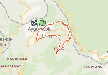
![](/images/other/stat-length.png)
![Randonnée Raquettes à neige Ayguatébia-Talau - Ayguatebia - Photo](https://media.geolcdn.com/t/1900/400/ext.pjpeg?maxdim=2&url=https%3A%2F%2Fstatic1.geolcdn.com%2Fsiteimages%2Fupload%2Ffiles%2F1524743153raquette.jpg)
Ayguatebia
jpipacific
Utilisateur
![Longueur](/images/other/stat-length.png)
![Altitude max](https://static1.geolcdn.com/siteimages/upload/files/1508320355ic_sort_altitude_max_24dp.png)
![Dénivelé positif](https://static1.geolcdn.com/siteimages/upload/files/1508320355ic_sort_den_pos_24dp.png)
![Km-Effort](/images/other/stat-length.png)
![Altitude min](https://static1.geolcdn.com/siteimages/upload/files/1508320355ic_sort_altitude_min_24dp.png)
![Dénivelé négatif](https://static1.geolcdn.com/siteimages/upload/files/1508320355ic_sort_den_neg_24dp.png)
![Boucle](https://static1.geolcdn.com/siteimages/upload/files/16400158638029165_repeat_loop_refresh_sync_direction_icon.png)
![Raquettes à neige](https://static1.geolcdn.com/sitytour/trail-icons/504.png)
2h51
Difficulté : Moyen
![Scannez ce code QR pour ouvrir la randonnée dans l'application SityTrail](https://capi.geolives.com/qq0zvz2zws4bq2lad0pu/sitytour/trails/538826/qr.png?size=200)
Application GPS de randonnée GRATUITE
À propos
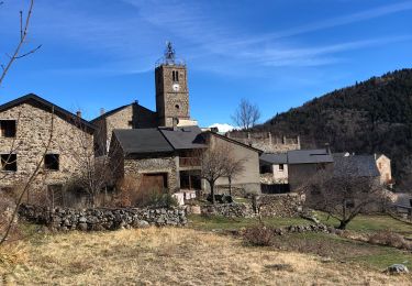
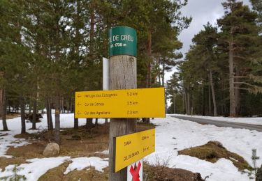
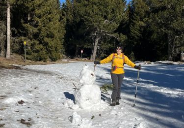
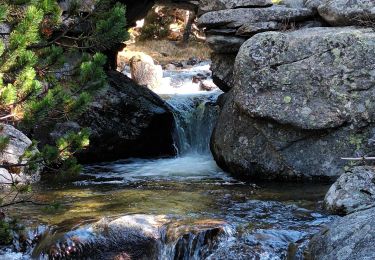
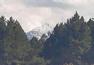
Randonnée Raquettes à neige de 7,3 km à découvrir à Occitanie, Pyrénées-Orientales, Ayguatébia-Talau. Cette randonnée est proposée par jpipacific.
Description
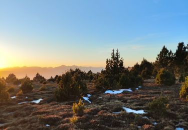
Pas assez sauvage. Beaucoup de route à prendre et à la vue tout le temps. Quelques points de vue sur la deuxième partie du parcours mais rien de bien sensationnel. Les dénivelés sont importants. La ballade ne vaut pas les efforts qu'elle demande. Point positif, nous avons vu deux fois des izards en début de parcours.
Localisation
Commentaires
Randonnées à proximité
![Randonnée Marche Railleu - 20230312 Boucle depuis Railleu - Photo](https://media.geolcdn.com/t/375/260/6ec33acc-251f-45d6-baf5-f5b7fe74b26f.jpg&format=jpg&maxdim=2)
![Marche Marche](https://static1.geolcdn.com/sitytour/trail-icons/101.png)
Marche
![](/images/other/stat-length.png)
![](https://static1.geolcdn.com/siteimages/upload/files/16400158638029165_repeat_loop_refresh_sync_direction_icon.png)
![Randonnée Raquettes à neige Railleu - Maximale Col de Creu - Photo](https://media.geolcdn.com/t/375/260/ext.jpg?maxdim=2&url=https%3A%2F%2Fservices.sitytrail.com%2FGeolivesWS%2FDownloadMedia.ashx%3FTrailID%3D922253%26Media%3Dfix__20180313153146.jpg)
![Raquettes à neige Raquettes à neige](https://static1.geolcdn.com/sitytour/trail-icons/504.png)
Raquettes à neige
![](/images/other/stat-length.png)
![](https://static1.geolcdn.com/siteimages/upload/files/16400158638029165_repeat_loop_refresh_sync_direction_icon.png)
![Randonnée V.T.T. Railleu - la couillue - Photo](https://media.geolcdn.com/t/375/260/ext.jpg?maxdim=2&url=https%3A%2F%2Fservices.sitytrail.com%2FGeolivesWS%2FDownloadMedia.ashx%3FTrailID%3D330610%26Media%3Dfix__20140803145941.jpg)
![V.T.T. V.T.T.](https://static1.geolcdn.com/sitytour/trail-icons/202.png)
V.T.T.
![](/images/other/stat-length.png)
![](https://static1.geolcdn.com/siteimages/upload/files/16400158638029165_repeat_loop_refresh_sync_direction_icon.png)
![Randonnée sport Ayguatébia-Talau - 20250206 col de Llose - refuge del Torn - Photo](https://media.geolcdn.com/t/375/260/aa6ad012-bbeb-4b11-b87f-98a53c6e7963.jpg&format=jpg&maxdim=2)
sport
![](/images/other/stat-length.png)
![](https://static1.geolcdn.com/siteimages/upload/files/16400158638029165_repeat_loop_refresh_sync_direction_icon.png)
![Randonnée Marche Railleu - refuge de la perdrix - Photo](https://media.geolcdn.com/t/375/260/accebc35-7569-48a9-9d1a-c6f2c0c31945.jpg&format=jpg&maxdim=2)
![Marche Marche](https://static1.geolcdn.com/sitytour/trail-icons/101.png)
Marche
![](/images/other/stat-length.png)
![](https://static1.geolcdn.com/siteimages/upload/files/16400158638029165_repeat_loop_refresh_sync_direction_icon.png)
![Randonnée Marche Ayguatébia-Talau - LLOSE au refuge el TORN - Photo](https://media.geolcdn.com/t/375/260/5a26c312-2b54-4f9a-9197-19455e17c96c.jpg&format=jpg&maxdim=2)
![Marche Marche](https://static1.geolcdn.com/sitytour/trail-icons/101.png)
Marche
![](/images/other/stat-length.png)
![](https://static1.geolcdn.com/siteimages/upload/files/16400158638029165_repeat_loop_refresh_sync_direction_icon.png)
![Randonnée Marche Railleu - 20230325 autre parcours sympa depuis Railleu - Photo](https://media.geolcdn.com/t/375/260/eff59e5d-1ddd-49c4-9fc4-244521da53aa.jpg&format=jpg&maxdim=2)
![Marche Marche](https://static1.geolcdn.com/sitytour/trail-icons/101.png)
Marche
![](/images/other/stat-length.png)
![](https://static1.geolcdn.com/siteimages/upload/files/16400158638029165_repeat_loop_refresh_sync_direction_icon.png)
![Randonnée Marche Railleu - railleu sansa - Photo](https://media.geolcdn.com/t/375/260/3ff29442-3449-4525-a6a7-a29e1ce36aba.jpg&format=jpg&maxdim=2)
![Marche Marche](https://static1.geolcdn.com/sitytour/trail-icons/101.png)
Marche
![](/images/other/stat-length.png)
![](https://static1.geolcdn.com/siteimages/upload/files/16400158638029165_repeat_loop_refresh_sync_direction_icon.png)
![Randonnée Marche Railleu - col de creux, de Sansa et de Torn - Photo](https://media.geolcdn.com/t/375/260/53a8880f-8b2c-449b-8893-b583b6294c2d.jpg&format=jpg&maxdim=2)
![Marche Marche](https://static1.geolcdn.com/sitytour/trail-icons/101.png)
Marche
![](/images/other/stat-length.png)
![](https://static1.geolcdn.com/siteimages/upload/files/16400158638029165_repeat_loop_refresh_sync_direction_icon.png)