![](/images/other/stat-length.png)
![Randonnée Marche Vexin-sur-Epte - Rando Santé 1 - Fontenay en Vexin - Photo](https://media.geolcdn.com/t/1900/400/ext.pjpeg?maxdim=2&url=https%3A%2F%2Fstatic1.geolcdn.com%2Fsiteimages%2Fupload%2Ffiles%2F1553511878bg_sport_marche.png)
Rando Santé 1 - Fontenay en Vexin
marcel.F
Utilisateur
![Longueur](/images/other/stat-length.png)
Longueur
4,9 km
![Altitude max](https://static1.geolcdn.com/siteimages/upload/files/1508320355ic_sort_altitude_max_24dp.png)
Altitude max
145 m
![Dénivelé positif](https://static1.geolcdn.com/siteimages/upload/files/1508320355ic_sort_den_pos_24dp.png)
Dénivelé positif
77 m
![Km-Effort](/images/other/stat-length.png)
Km-Effort
5,9 km
![Altitude min](https://static1.geolcdn.com/siteimages/upload/files/1508320355ic_sort_altitude_min_24dp.png)
Altitude min
99 m
![Dénivelé négatif](https://static1.geolcdn.com/siteimages/upload/files/1508320355ic_sort_den_neg_24dp.png)
Dénivelé négatif
76 m
![Boucle](https://static1.geolcdn.com/siteimages/upload/files/16400158638029165_repeat_loop_refresh_sync_direction_icon.png)
Boucle
Oui
Date de création :
2019-04-01 20:24:02.411
Dernière modification :
2019-04-07 14:10:37.75
![Marche](https://static1.geolcdn.com/sitytour/trail-icons/101.png)
1h30
Difficulté : Facile
![Scannez ce code QR pour ouvrir la randonnée dans l'application SityTrail](https://capi.geolives.com/qq0zvz2zws4bq2lad0pu/sitytour/trails/532854/qr.png?size=200)
Application GPS de randonnée GRATUITE
À propos
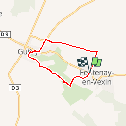
Randonnée Marche de 4,9 km à découvrir à Normandie, Eure, Vexin-sur-Epte. Cette randonnée est proposée par marcel.F.
Description
Boucle au départ du parking école de Fontenay en Vexin (accès par D181 après Les Thilliers en Vexin)
via moulin des Groux et Guitry
Localisation
Pays :
France
Région :
Normandie
Département/Province :
Eure
Commune :
Vexin-sur-Epte
Localité :
Unknown
Départ:(Dec)
Départ:(UTM)
395627 ; 5451836 (31U) N.
Commentaires
Randonnées à proximité
![Randonnée Marche Mézières-en-Vexin - Mézières-en-Vexin - François 1er - Photo](https://media.geolcdn.com/t/375/260/ext.jpg?maxdim=2&url=https%3A%2F%2Fstatic1.geolcdn.com%2Fsiteimages%2Fupload%2Ffiles%2F1553511878bg_sport_marche.png)
![Marche Marche](https://static1.geolcdn.com/sitytour/trail-icons/101.png)
Mézières-en-Vexin - François 1er
Marche
Facile
(1)
Mézières-en-Vexin,
Normandie,
Eure,
France
![](/images/other/stat-length.png)
11 km | 13,1 km-effort
2h 50min
![](https://static1.geolcdn.com/siteimages/upload/files/16400158638029165_repeat_loop_refresh_sync_direction_icon.png)
Oui
![Randonnée Marche Vexin-sur-Epte - Tourny - le moulin de pierre variante 2 - Photo](https://media.geolcdn.com/t/375/260/ext.jpg?maxdim=2&url=https%3A%2F%2Fservices.sitytrail.com%2FGeolivesWS%2FDownloadMedia.ashx%3FTrailID%3D1098186%26Media%3Df5555db9-f7bc-4527-9b07-edd230d56814.jpg)
![Marche Marche](https://static1.geolcdn.com/sitytour/trail-icons/101.png)
Tourny - le moulin de pierre variante 2
Marche
Facile
Vexin-sur-Epte,
Normandie,
Eure,
France
![](/images/other/stat-length.png)
9,9 km | 11,1 km-effort
2h 22min
![](https://static1.geolcdn.com/siteimages/upload/files/16400158638029165_repeat_loop_refresh_sync_direction_icon.png)
Oui
![Randonnée Marche Vexin-sur-Epte - Rando Douce 2 - Tourny - Photo](https://media.geolcdn.com/t/375/260/ext.jpg?maxdim=2&url=https%3A%2F%2Fservices.sitytrail.com%2FGeolivesWS%2FDownloadMedia.ashx%3FTrailID%3D532902%26Media%3Df5555db9-f7bc-4527-9b07-edd230d56814.jpg)
![Marche Marche](https://static1.geolcdn.com/sitytour/trail-icons/101.png)
Rando Douce 2 - Tourny
Marche
Moyen
Vexin-sur-Epte,
Normandie,
Eure,
France
![](/images/other/stat-length.png)
6,9 km | 7,8 km-effort
2h 0min
![](https://static1.geolcdn.com/siteimages/upload/files/16400158638029165_repeat_loop_refresh_sync_direction_icon.png)
Oui
![Randonnée Marche Vexin-sur-Epte - Rando Santé 1 - Tourny - Photo](https://media.geolcdn.com/t/375/260/ext.jpg?maxdim=2&url=https%3A%2F%2Fservices.sitytrail.com%2FGeolivesWS%2FDownloadMedia.ashx%3FTrailID%3D532901%26Media%3Df5555db9-f7bc-4527-9b07-edd230d56814.jpg)
![Marche Marche](https://static1.geolcdn.com/sitytour/trail-icons/101.png)
Rando Santé 1 - Tourny
Marche
Facile
Vexin-sur-Epte,
Normandie,
Eure,
France
![](/images/other/stat-length.png)
4,5 km | 5,1 km-effort
1h 30min
![](https://static1.geolcdn.com/siteimages/upload/files/16400158638029165_repeat_loop_refresh_sync_direction_icon.png)
Oui
![Randonnée Marche Vexin-sur-Epte - Tourny - le moulin de pierre court - Photo](https://media.geolcdn.com/t/375/260/ext.jpg?maxdim=2&url=https%3A%2F%2Fservices.sitytrail.com%2FGeolivesWS%2FDownloadMedia.ashx%3FTrailID%3D527716%26Media%3Df5555db9-f7bc-4527-9b07-edd230d56814.jpg)
![Marche Marche](https://static1.geolcdn.com/sitytour/trail-icons/101.png)
Tourny - le moulin de pierre court
Marche
Facile
Vexin-sur-Epte,
Normandie,
Eure,
France
![](/images/other/stat-length.png)
8 km | 9 km-effort
1h 59min
![](https://static1.geolcdn.com/siteimages/upload/files/16400158638029165_repeat_loop_refresh_sync_direction_icon.png)
Oui
![Randonnée Marche Villers-en-Vexin - Villers en Vexin à Cantiers - Photo](https://media.geolcdn.com/t/375/260/ext.jpg?maxdim=2&url=https%3A%2F%2Fstatic1.geolcdn.com%2Fsiteimages%2Fupload%2Ffiles%2F1553511878bg_sport_marche.png)
![Marche Marche](https://static1.geolcdn.com/sitytour/trail-icons/101.png)
Villers en Vexin à Cantiers
Marche
Moyen
Villers-en-Vexin,
Normandie,
Eure,
France
![](/images/other/stat-length.png)
9,1 km | 10 km-effort
2h 16min
![](https://static1.geolcdn.com/siteimages/upload/files/16400158638029165_repeat_loop_refresh_sync_direction_icon.png)
Oui
![Randonnée Marche Vexin-sur-Epte - TOURNY Version MC2 - Photo](https://media.geolcdn.com/t/375/260/ext.jpg?maxdim=2&url=https%3A%2F%2Fstatic1.geolcdn.com%2Fsiteimages%2Fupload%2Ffiles%2F1553511878bg_sport_marche.png)
![Marche Marche](https://static1.geolcdn.com/sitytour/trail-icons/101.png)
TOURNY Version MC2
Marche
Très facile
Vexin-sur-Epte,
Normandie,
Eure,
France
![](/images/other/stat-length.png)
9,7 km | 10,7 km-effort
1h 53min
![](https://static1.geolcdn.com/siteimages/upload/files/16400158638029165_repeat_loop_refresh_sync_direction_icon.png)
Oui
![Randonnée Marche Vexin-sur-Epte - Tourny MOulin de Pierre 3 - Photo](https://media.geolcdn.com/t/375/260/ext.jpg?maxdim=2&url=https%3A%2F%2Fstatic1.geolcdn.com%2Fsiteimages%2Fupload%2Ffiles%2F1553511878bg_sport_marche.png)
![Marche Marche](https://static1.geolcdn.com/sitytour/trail-icons/101.png)
Tourny MOulin de Pierre 3
Marche
Difficile
Vexin-sur-Epte,
Normandie,
Eure,
France
![](/images/other/stat-length.png)
12,2 km | 13,4 km-effort
2h 59min
![](https://static1.geolcdn.com/siteimages/upload/files/16400158638029165_repeat_loop_refresh_sync_direction_icon.png)
Oui
![Randonnée Marche Vexin-sur-Epte - Tourny (le moulin de pierre)_12Km - Photo](https://media.geolcdn.com/t/375/260/ext.jpg?maxdim=2&url=https%3A%2F%2Fstatic1.geolcdn.com%2Fsiteimages%2Fupload%2Ffiles%2F1553511878bg_sport_marche.png)
![Marche Marche](https://static1.geolcdn.com/sitytour/trail-icons/101.png)
Tourny (le moulin de pierre)_12Km
Marche
Facile
Vexin-sur-Epte,
Normandie,
Eure,
France
![](/images/other/stat-length.png)
12 km | 13,2 km-effort
2h 55min
![](https://static1.geolcdn.com/siteimages/upload/files/16400158638029165_repeat_loop_refresh_sync_direction_icon.png)
Oui