![](/images/other/stat-length.png)
![Randonnée Raquettes à neige Bera - La Rhune depuis col Lizunaga avec sommet réal - Photo](https://media.geolcdn.com/t/1900/400/ext.pjpeg?maxdim=2&url=https%3A%2F%2Fservices.sitytrail.com%2FGeolivesWS%2FDownloadMedia.ashx%3FTrailID%3D519996%26Media%3Dfix__20160128143113.jpg)
La Rhune depuis col Lizunaga avec sommet réal
DECHAMPD
Utilisateur
![Longueur](/images/other/stat-length.png)
Longueur
10,6 km
![Altitude max](https://static1.geolcdn.com/siteimages/upload/files/1508320355ic_sort_altitude_max_24dp.png)
Altitude max
855 m
![Dénivelé positif](https://static1.geolcdn.com/siteimages/upload/files/1508320355ic_sort_den_pos_24dp.png)
Dénivelé positif
685 m
![Km-Effort](/images/other/stat-length.png)
Km-Effort
19,8 km
![Altitude min](https://static1.geolcdn.com/siteimages/upload/files/1508320355ic_sort_altitude_min_24dp.png)
Altitude min
208 m
![Dénivelé négatif](https://static1.geolcdn.com/siteimages/upload/files/1508320355ic_sort_den_neg_24dp.png)
Dénivelé négatif
686 m
![Boucle](https://static1.geolcdn.com/siteimages/upload/files/16400158638029165_repeat_loop_refresh_sync_direction_icon.png)
Boucle
Oui
Date de création :
2019-01-14 17:32:04.898
Dernière modification :
2019-01-14 17:32:04.973
![Raquettes à neige](https://static1.geolcdn.com/sitytour/trail-icons/504.png)
4h17
Difficulté : Moyen
![Scannez ce code QR pour ouvrir la randonnée dans l'application SityTrail](https://capi.geolives.com/qq0zvz2zws4bq2lad0pu/sitytour/trails/519996/qr.png?size=200)
Application GPS de randonnée GRATUITE
À propos
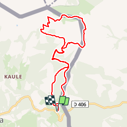
Randonnée Raquettes à neige de 10,6 km à découvrir à Navarre, Inconnu, Bera. Cette randonnée est proposée par DECHAMPD.
Description
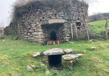
départ Benta Lizuniagako, Gondendiagako Bidea, Kondendiagako lepoa, Larun et descente en suivant la ligne frontière BF .. à BF par Urkilako Lepoa, Baratz, Meaka, et ligne de crête jusqu'au point de départ.
Localisation
Pays :
Espagne
Région :
Navarre
Département/Province :
Inconnu
Commune :
Bera
Localité :
Unknown
Départ:(Dec)
Départ:(UTM)
610994 ; 4793118 (30T) N.
Commentaires
Randonnées à proximité
![Marche Marche](https://static1.geolcdn.com/sitytour/trail-icons/101.png)
La Rhune
Marche
Moyen
Sare,
Nouvelle-Aquitaine,
Pyrénées-Atlantiques,
France
![](/images/other/stat-length.png)
6,7 km | 9,7 km-effort
2h 18min
![](https://static1.geolcdn.com/siteimages/upload/files/16400158638029165_repeat_loop_refresh_sync_direction_icon.png)
Non
![Randonnée Marche Sare - La rhune par la face EST - Photo](https://media.geolcdn.com/t/375/260/ext.jpg?maxdim=2&url=https%3A%2F%2Fstatic1.geolcdn.com%2Fsiteimages%2Fupload%2Ffiles%2F1553511878bg_sport_marche.png)
![Marche Marche](https://static1.geolcdn.com/sitytour/trail-icons/101.png)
La rhune par la face EST
Marche
Moyen
(1)
Sare,
Nouvelle-Aquitaine,
Pyrénées-Atlantiques,
France
![](/images/other/stat-length.png)
13,8 km | 26 km-effort
5h 10min
![](https://static1.geolcdn.com/siteimages/upload/files/16400158638029165_repeat_loop_refresh_sync_direction_icon.png)
Oui
![Randonnée Marche Sare - sare les palombieres - Photo](https://media.geolcdn.com/t/375/260/ext.jpg?maxdim=2&url=https%3A%2F%2Fservices.sitytrail.com%2FGeolivesWS%2FDownloadMedia.ashx%3FTrailID%3D226934%26Media%3D20131002143837.jpg)
![Marche Marche](https://static1.geolcdn.com/sitytour/trail-icons/101.png)
sare les palombieres
Marche
Facile
Sare,
Nouvelle-Aquitaine,
Pyrénées-Atlantiques,
France
![](/images/other/stat-length.png)
15,8 km | 24 km-effort
4h 44min
![](https://static1.geolcdn.com/siteimages/upload/files/16400158638029165_repeat_loop_refresh_sync_direction_icon.png)
Oui
![Randonnée Marche Sare - la rhune depuis Sare (2) - Photo](https://media.geolcdn.com/t/375/260/ext.jpg?maxdim=2&url=https%3A%2F%2Fstatic1.geolcdn.com%2Fsiteimages%2Fupload%2Ffiles%2F1553511878bg_sport_marche.png)
![Marche Marche](https://static1.geolcdn.com/sitytour/trail-icons/101.png)
la rhune depuis Sare (2)
Marche
Très facile
(4)
Sare,
Nouvelle-Aquitaine,
Pyrénées-Atlantiques,
France
![](/images/other/stat-length.png)
13,9 km | 26 km-effort
4h 0min
![](https://static1.geolcdn.com/siteimages/upload/files/16400158638029165_repeat_loop_refresh_sync_direction_icon.png)
Oui
![Randonnée Marche Sare - atxuria zugaramurdi - Photo](https://media.geolcdn.com/t/375/260/ext.jpg?maxdim=2&url=https%3A%2F%2Fstatic1.geolcdn.com%2Fsiteimages%2Fupload%2Ffiles%2F1553511878bg_sport_marche.png)
![Marche Marche](https://static1.geolcdn.com/sitytour/trail-icons/101.png)
atxuria zugaramurdi
Marche
Très facile
(3)
Sare,
Nouvelle-Aquitaine,
Pyrénées-Atlantiques,
France
![](/images/other/stat-length.png)
10,3 km | 18,7 km-effort
3h 50min
![](https://static1.geolcdn.com/siteimages/upload/files/16400158638029165_repeat_loop_refresh_sync_direction_icon.png)
Oui
![Randonnée Marche Sare - Lizarieta descente par palombieres - Photo](https://media.geolcdn.com/t/375/260/9d6ad3d3-a9ac-4160-b5e2-482251e1a583.jpg&format=jpg&maxdim=2)
![Marche Marche](https://static1.geolcdn.com/sitytour/trail-icons/101.png)
Lizarieta descente par palombieres
Marche
Très facile
Sare,
Nouvelle-Aquitaine,
Pyrénées-Atlantiques,
France
![](/images/other/stat-length.png)
8,9 km | 11,9 km-effort
2h 49min
![](https://static1.geolcdn.com/siteimages/upload/files/16400158638029165_repeat_loop_refresh_sync_direction_icon.png)
Non
![Randonnée Marche Sare - col de lizarrieta et col des 3 bornes - Photo](https://media.geolcdn.com/t/375/260/4a8eca64-9908-469c-ac1f-6551c3878583.jpg&format=jpg&maxdim=2)
![Marche Marche](https://static1.geolcdn.com/sitytour/trail-icons/101.png)
col de lizarrieta et col des 3 bornes
Marche
Difficile
Sare,
Nouvelle-Aquitaine,
Pyrénées-Atlantiques,
France
![](/images/other/stat-length.png)
13 km | 18,5 km-effort
3h 45min
![](https://static1.geolcdn.com/siteimages/upload/files/16400158638029165_repeat_loop_refresh_sync_direction_icon.png)
Oui
![Randonnée Marche Sare - Lizarrieta, Zentinel, col des 3 bornes, 2024 03 04. - Photo](https://media.geolcdn.com/t/375/260/8ac35c6d-8e84-4286-9748-27c916c27140.jpg&format=jpg&maxdim=2)
![Marche Marche](https://static1.geolcdn.com/sitytour/trail-icons/101.png)
Lizarrieta, Zentinel, col des 3 bornes, 2024 03 04.
Marche
Difficile
Sare,
Nouvelle-Aquitaine,
Pyrénées-Atlantiques,
France
![](/images/other/stat-length.png)
12,4 km | 17,8 km-effort
4h 3min
![](https://static1.geolcdn.com/siteimages/upload/files/16400158638029165_repeat_loop_refresh_sync_direction_icon.png)
Oui
![Randonnée Marche Sare - Boucle autour de Sare - Photo](https://media.geolcdn.com/t/375/260/2c69393f-a5c8-4362-8790-7ae34f1b4736.jpeg&format=jpg&maxdim=2)
![Marche Marche](https://static1.geolcdn.com/sitytour/trail-icons/101.png)
Boucle autour de Sare
Marche
Difficile
Sare,
Nouvelle-Aquitaine,
Pyrénées-Atlantiques,
France
![](/images/other/stat-length.png)
10,7 km | 15,1 km-effort
3h 26min
![](https://static1.geolcdn.com/siteimages/upload/files/16400158638029165_repeat_loop_refresh_sync_direction_icon.png)
Oui