![](/images/other/stat-length.png)
![Randonnée Marche Senez - Majastres: Le hameau du Poil - Photo](https://media.geolcdn.com/t/1900/400/1f4a7a18-e94f-45d2-913d-85325ad93478.jpg&format=pjpeg&maxdim=2)
Majastres: Le hameau du Poil
lviallet
Utilisateur
![Longueur](/images/other/stat-length.png)
Longueur
9,3 km
![Altitude max](https://static1.geolcdn.com/siteimages/upload/files/1508320355ic_sort_altitude_max_24dp.png)
Altitude max
1217 m
![Dénivelé positif](https://static1.geolcdn.com/siteimages/upload/files/1508320355ic_sort_den_pos_24dp.png)
Dénivelé positif
338 m
![Km-Effort](/images/other/stat-length.png)
Km-Effort
13,8 km
![Altitude min](https://static1.geolcdn.com/siteimages/upload/files/1508320355ic_sort_altitude_min_24dp.png)
Altitude min
905 m
![Dénivelé négatif](https://static1.geolcdn.com/siteimages/upload/files/1508320355ic_sort_den_neg_24dp.png)
Dénivelé négatif
334 m
![Boucle](https://static1.geolcdn.com/siteimages/upload/files/16400158638029165_repeat_loop_refresh_sync_direction_icon.png)
Boucle
Oui
Date de création :
2016-09-05 00:00:00.0
Dernière modification :
2016-09-05 00:00:00.0
![Marche](https://static1.geolcdn.com/sitytour/trail-icons/101.png)
2h53
Difficulté : Difficile
![Scannez ce code QR pour ouvrir la randonnée dans l'application SityTrail](https://capi.geolives.com/qq0zvz2zws4bq2lad0pu/sitytour/trails/513339/qr.png?size=200)
Application GPS de randonnée GRATUITE
À propos
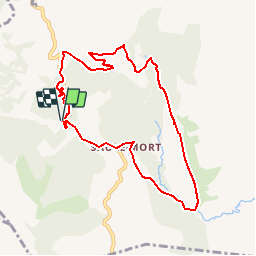
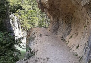
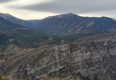
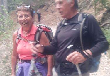
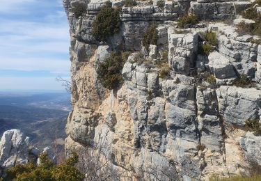
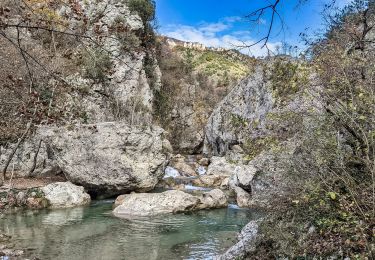
Randonnée Marche de 9,3 km à découvrir à Provence-Alpes-Côte d'Azur, Alpes-de-Haute-Provence, Senez. Cette randonnée est proposée par lviallet.
Description
Après Valensole, prendre D17 juste avant Mézel.
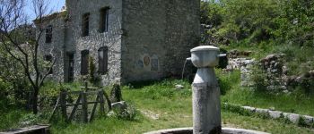
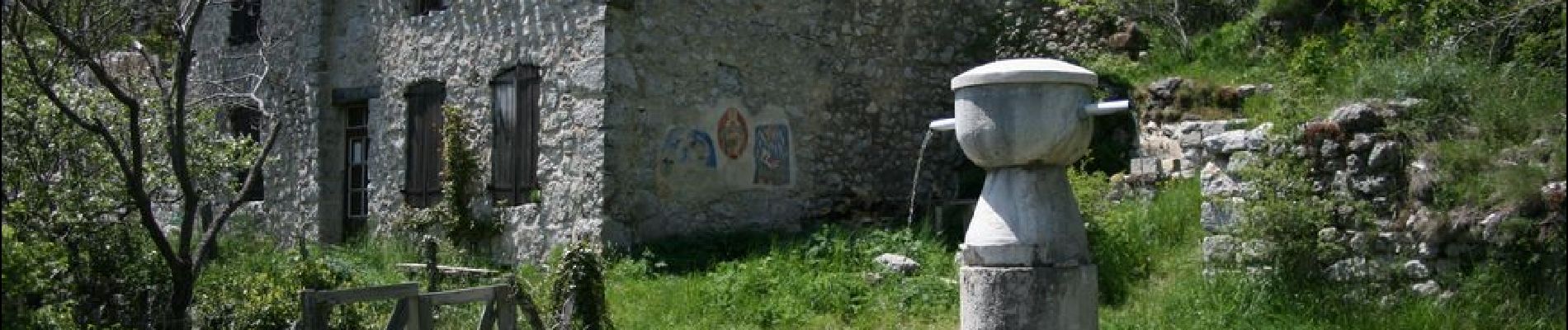
Le hameau du Poil est planté sur un piton rocheuxet comptait au milieu du XIXe siècle 400 âmes.
Localisation
Pays :
France
Région :
Provence-Alpes-Côte d'Azur
Département/Province :
Alpes-de-Haute-Provence
Commune :
Senez
Localité :
Le Poil
Départ:(Dec)
Départ:(UTM)
280456 ; 4868728 (32T) N.
Commentaires
Randonnées à proximité
![Randonnée Marche Estoublon - Gorges de Trévans - Estoublon - Photo](https://media.geolcdn.com/t/375/260/ext.jpg?maxdim=2&url=https%3A%2F%2Fservices.sitytrail.com%2FGeolivesWS%2FDownloadMedia.ashx%3FTrailID%3D106721%26Media%3D11374_5.jpg)
![Marche Marche](https://static1.geolcdn.com/sitytour/trail-icons/101.png)
Gorges de Trévans - Estoublon
Marche
Difficile
(1)
Estoublon,
Provence-Alpes-Côte d'Azur,
Alpes-de-Haute-Provence,
France
![](/images/other/stat-length.png)
8,9 km | 14,1 km-effort
3h 0min
![](https://static1.geolcdn.com/siteimages/upload/files/16400158638029165_repeat_loop_refresh_sync_direction_icon.png)
Oui
![Randonnée Marche Estoublon - TREVANS, Chateau de Trevans, les Beluguettes. Cotes Chaudes , Belvédère des Gorges , Turquet ,o quet - Photo](https://media.geolcdn.com/t/375/260/488d605b-c812-4edd-a2c1-2f4802305dc3.jpg&format=jpg&maxdim=2)
![Marche Marche](https://static1.geolcdn.com/sitytour/trail-icons/101.png)
TREVANS, Chateau de Trevans, les Beluguettes. Cotes Chaudes , Belvédère des...
Marche
Moyen
Estoublon,
Provence-Alpes-Côte d'Azur,
Alpes-de-Haute-Provence,
France
![](/images/other/stat-length.png)
15,1 km | 24 km-effort
4h 48min
![](https://static1.geolcdn.com/siteimages/upload/files/16400158638029165_repeat_loop_refresh_sync_direction_icon.png)
Oui
![Randonnée Marche Beynes - Montagne de Beynes 11kms 720m - Photo](https://media.geolcdn.com/t/375/260/0924528c-4d8c-48ab-ad20-f85077c2766f.jpg&format=jpg&maxdim=2)
![Marche Marche](https://static1.geolcdn.com/sitytour/trail-icons/101.png)
Montagne de Beynes 11kms 720m
Marche
Très difficile
Beynes,
Provence-Alpes-Côte d'Azur,
Alpes-de-Haute-Provence,
France
![](/images/other/stat-length.png)
11 km | 21 km-effort
6h 28min
![](https://static1.geolcdn.com/siteimages/upload/files/16400158638029165_repeat_loop_refresh_sync_direction_icon.png)
Oui
![Randonnée Marche Estoublon - Trevans les gorges - Photo](https://media.geolcdn.com/t/375/260/2cbe37e7-5ddf-4213-89bc-0a9ca520d8c1.jpg&format=jpg&maxdim=2)
![Marche Marche](https://static1.geolcdn.com/sitytour/trail-icons/101.png)
Trevans les gorges
Marche
Très difficile
Estoublon,
Provence-Alpes-Côte d'Azur,
Alpes-de-Haute-Provence,
France
![](/images/other/stat-length.png)
13,1 km | 21 km-effort
4h 49min
![](https://static1.geolcdn.com/siteimages/upload/files/16400158638029165_repeat_loop_refresh_sync_direction_icon.png)
Oui
![Randonnée Marche Beynes - 2023-03-17 Montagne de Beyne - Photo](https://media.geolcdn.com/t/375/260/a2f9f9ce-2317-441f-8351-fbd6bbd22b1f.jpg&format=jpg&maxdim=2)
![Marche Marche](https://static1.geolcdn.com/sitytour/trail-icons/101.png)
2023-03-17 Montagne de Beyne
Marche
Moyen
Beynes,
Provence-Alpes-Côte d'Azur,
Alpes-de-Haute-Provence,
France
![](/images/other/stat-length.png)
14,4 km | 26 km-effort
6h 28min
![](https://static1.geolcdn.com/siteimages/upload/files/16400158638029165_repeat_loop_refresh_sync_direction_icon.png)
Oui
![Randonnée Marche Estoublon - Gorges de Trevans par Valbonnette - Photo](https://media.geolcdn.com/t/375/260/10517f6a-6ec3-4f7b-85a2-34d58762c642.jpg&format=jpg&maxdim=2)
![Marche Marche](https://static1.geolcdn.com/sitytour/trail-icons/101.png)
Gorges de Trevans par Valbonnette
Marche
Facile
Estoublon,
Provence-Alpes-Côte d'Azur,
Alpes-de-Haute-Provence,
France
![](/images/other/stat-length.png)
13,9 km | 22 km-effort
5h 8min
![](https://static1.geolcdn.com/siteimages/upload/files/16400158638029165_repeat_loop_refresh_sync_direction_icon.png)
Oui
![Randonnée Marche Estoublon - 2023-02-21 Gorges de Trévans - Passerelle de la Délasse - Photo](https://media.geolcdn.com/t/375/260/0eeaaad3-f154-4199-b0d4-f7114f5176f6.jpg&format=jpg&maxdim=2)
![Marche Marche](https://static1.geolcdn.com/sitytour/trail-icons/101.png)
2023-02-21 Gorges de Trévans - Passerelle de la Délasse
Marche
Moyen
Estoublon,
Provence-Alpes-Côte d'Azur,
Alpes-de-Haute-Provence,
France
![](/images/other/stat-length.png)
12,6 km | 20 km-effort
4h 38min
![](https://static1.geolcdn.com/siteimages/upload/files/16400158638029165_repeat_loop_refresh_sync_direction_icon.png)
Non
![Randonnée Marche Beynes - 04 La montagne de Beynes (Variante 05/2022) - Photo](https://media.geolcdn.com/t/375/260/00ffcda8-2af0-4879-a93e-d3abe306c026.jpg&format=jpg&maxdim=2)
![Marche Marche](https://static1.geolcdn.com/sitytour/trail-icons/101.png)
04 La montagne de Beynes (Variante 05/2022)
Marche
Moyen
Beynes,
Provence-Alpes-Côte d'Azur,
Alpes-de-Haute-Provence,
France
![](/images/other/stat-length.png)
12,9 km | 23 km-effort
7h 15min
![](https://static1.geolcdn.com/siteimages/upload/files/16400158638029165_repeat_loop_refresh_sync_direction_icon.png)
Oui
![Randonnée Marche Estoublon - gorges de trevans sentier de valbonette - Photo](https://media.geolcdn.com/t/375/260/e95b5ac0-ca3e-4559-bbd5-f5d21be426a1.jpg&format=jpg&maxdim=2)
![Marche Marche](https://static1.geolcdn.com/sitytour/trail-icons/101.png)
gorges de trevans sentier de valbonette
Marche
Moyen
Estoublon,
Provence-Alpes-Côte d'Azur,
Alpes-de-Haute-Provence,
France
![](/images/other/stat-length.png)
9,7 km | 15,3 km-effort
3h 24min
![](https://static1.geolcdn.com/siteimages/upload/files/16400158638029165_repeat_loop_refresh_sync_direction_icon.png)
Oui